
Thorpe Fell Top
Encyclopedia
Thorpe Fell Top is the top of the hill of Burnsall and Thorpe Fell in the Yorkshire Dales
, itself forming part of a larger wedge of ground between Wharfedale
and Skipton
.
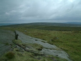
 The summit of this grouse
moor
is 506 metres above sea level and topped with a trig point
. It was listed in Alan Dawson's "The Relative Hills of Britain" as a Marilyn
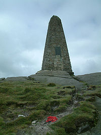
. However, a number of recent observations and measurements suggest that the base of the war memorial at the top of Cracoe Fell some 1.7 km (1.1 mi) to the south-west, is probably higher, perhaps as high as 510 metres.
Thorpe Fell Top is probably most easily visited from either Thorpe or Burnsall. The track and path marked on Ordnance Survey
maps to the north and west of the summit does continue all the way to the top of Cracoe Fell. The latter can also be reached along Fell Lane from the village of Cracoe.
Yorkshire Dales
The Yorkshire Dales is the name given to an upland area in Northern England.The area lies within the historic county boundaries of Yorkshire, though it spans the ceremonial counties of North Yorkshire, West Yorkshire and Cumbria...
, itself forming part of a larger wedge of ground between Wharfedale
Wharfedale
Wharfedale is one of the Yorkshire Dales in England. It is the valley of the River Wharfe. Towns and villages in Wharfedale include Buckden, Kettlewell, Conistone, Grassington, Hebden, Ilkley, Burley-in-Wharfedale, Otley, Pool-in-Wharfedale, Arthington, Collingham, and Wetherby...
and Skipton
Skipton
Skipton is a market town and civil parish within the Craven district of North Yorkshire, England. It is located along the course of both the Leeds and Liverpool Canal and the River Aire, on the south side of the Yorkshire Dales, northwest of Bradford and west of York...
.
Grouse
Grouse are a group of birds from the order Galliformes. They are sometimes considered a family Tetraonidae, though the American Ornithologists' Union and many others include grouse as a subfamily Tetraoninae in the family Phasianidae...
moor
Moorland
Moorland or moor is a type of habitat, in the temperate grasslands, savannas, and shrublands biome, found in upland areas, characterised by low-growing vegetation on acidic soils and heavy fog...
is 506 metres above sea level and topped with a trig point
Trig point
A triangulation station, also known as a triangulation pillar, trigonometrical station, trigonometrical point, trig station, trig beacon or trig point, and sometimes informally as a trig, is a fixed surveying station, used in geodetic surveying and other surveying projects in its vicinity...
. It was listed in Alan Dawson's "The Relative Hills of Britain" as a Marilyn
Marilyn (hill)
A Marilyn is a mountain or hill in the United Kingdom, Republic of Ireland or Isle of Man with a relative height of at least 150 metres , regardless of absolute height or other merit...
. However, a number of recent observations and measurements suggest that the base of the war memorial at the top of Cracoe Fell some 1.7 km (1.1 mi) to the south-west, is probably higher, perhaps as high as 510 metres.
Thorpe Fell Top is probably most easily visited from either Thorpe or Burnsall. The track and path marked on Ordnance Survey
Ordnance Survey
Ordnance Survey , an executive agency and non-ministerial government department of the Government of the United Kingdom, is the national mapping agency for Great Britain, producing maps of Great Britain , and one of the world's largest producers of maps.The name reflects its creation together with...
maps to the north and west of the summit does continue all the way to the top of Cracoe Fell. The latter can also be reached along Fell Lane from the village of Cracoe.