
Thomas, West Virginia
Encyclopedia
Tucker County, West Virginia
As of the census of 2000, there were 7,321 people, 3,052 households, and 2,121 families residing in the county. The population density was 18 people per square mile . There were 4,634 housing units at an average density of 11 per square mile...
, West Virginia
West Virginia
West Virginia is a state in the Appalachian and Southeastern regions of the United States, bordered by Virginia to the southeast, Kentucky to the southwest, Ohio to the northwest, Pennsylvania to the northeast and Maryland to the east...
, United States
United States
The United States of America is a federal constitutional republic comprising fifty states and a federal district...
. The population was 452 at the 2000 census.
History
The town was named for Thomas Beall DavisThomas Beall Davis
Thomas Beall Davis , of Keyser, West Virginia, was an American politician.-Biography:Davis was born in Baltimore, Maryland, the brother of Henry Gassaway Davis....
.
The Cottrill Opera House
Cottrill Opera House
Cottrill Opera House, known since 1915 as Sutton's Opera House or Sutton Theater, is a historic vaudeville and movie theater building in Thomas, Tucker County, West Virginia. It was built in 1902, and is a rectangular brick building with a high front that appears to be four stories tall. The...
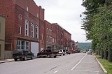
, Fairfax Stone, and Thomas Commercial Historic District
Thomas Commercial Historic District
Thomas Commercial Historic District is a national historic district located at Thomas, Tucker County, West Virginia. It encompasses 48 contributing buildings and two contributing structures. They include the business and commercial core of Thomas...
are listed on the National Register of Historic Places
National Register of Historic Places
The National Register of Historic Places is the United States government's official list of districts, sites, buildings, structures, and objects deemed worthy of preservation...
.
Geography
Thomas is located at 39°8′53"N 79°29′50"W (39.148077, -79.497174), along the North Fork of the Blackwater RiverBlackwater River (West Virginia)
The Blackwater River is a river in the Allegheny Mountains of eastern West Virginia, USA. Via the Black Fork, it is a principal tributary of the Cheat River. Via the Cheat, the Monongahela and the Ohio rivers, it is part of the watershed of the Mississippi River and drains an area of...
.
According to the United States Census Bureau
United States Census Bureau
The United States Census Bureau is the government agency that is responsible for the United States Census. It also gathers other national demographic and economic data...
, the city has a total area of 0.6 square miles (1.6 km²), all of it land.
Demographics
As of the censusCensus
A census is the procedure of systematically acquiring and recording information about the members of a given population. It is a regularly occurring and official count of a particular population. The term is used mostly in connection with national population and housing censuses; other common...
of 2000, there were 452 people, 224 households, and 127 families residing in the city. The population density
Population density
Population density is a measurement of population per unit area or unit volume. It is frequently applied to living organisms, and particularly to humans...
was 753.6 people per square mile (290.9/km²). There were 280 housing units at an average density of 466.8 per square mile (180.2/km²). The racial makeup of the city was 98.67% White, and 1.33% from two or more races.
There were 224 households out of which 16.5% had children under the age of 18 living with them, 46.0% were married couples
Marriage
Marriage is a social union or legal contract between people that creates kinship. It is an institution in which interpersonal relationships, usually intimate and sexual, are acknowledged in a variety of ways, depending on the culture or subculture in which it is found...
living together, 7.6% had a female householder with no husband present, and 42.9% were non-families. 39.7% of all households were made up of individuals and 23.7% had someone living alone who was 65 years of age or older. The average household size was 2.02 and the average family size was 2.69.
In the city the population was spread out with 15.0% under the age of 18, 5.5% from 18 to 24, 24.1% from 25 to 44, 33.8% from 45 to 64, and 21.5% who were 65 years of age or older. The median age was 48 years. For every 100 females there were 85.2 males. For every 100 females age 18 and over, there were 87.3 males.
The median income for a household in the city was $22,443, and the median income for a family was $25,417. Males had a median income of $27,188 versus $14,886 for females. The per capita income
Per capita income
Per capita income or income per person is a measure of mean income within an economic aggregate, such as a country or city. It is calculated by taking a measure of all sources of income in the aggregate and dividing it by the total population...
for the city was $14,918. About 13.8% of families and 13.7% of the population were below the poverty line, including 19.1% of those under age 18 and 11.5% of those age 65 or over.