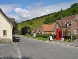
Thixendale
Encyclopedia
Thixendale is a tiny village and civil parish in the Ryedale
district of North Yorkshire
, England
. It is located in the Yorkshire Wolds
, about 20 miles east of York
.
The population of the village and surrounding farms is 130.
For travellers looking for a quaint little place to sleep (during summer months), Thixendale is an interesting choice. It is a reasonable driving distance from York, and provides serene country landscapes and interesting hikes in the immediate vicinity, including a popular walk to the nearby Wharram Percy
, a deserted medieval village
. A tiny no-frills (and no-shower) youth hostel
used to serve frugal travellers, until it was closed in 1999. Other accommodation options are still available.
The Yorkshire Wolds Way
National Trail, a long distance footpath passes to the east end of the village.
The church of St Mary, Thixendale is one of a group of village buildings constructed to designs by George Edmund Street
in 1868-70. It is on the Sykes Churches Trail
devised by the East Yorkshire Historic Churches Group.
For many years until the late 1990s, it was obscured from television transmissions by the nearby landscape until a small transmitter was built to provide villagers with terrestrial television for the first time.
Ryedale
Ryedale is a non-metropolitan district of the shire county of North Yorkshire in England. Settlements include Helmsley, Kirkbymoorside, Malton, Norton-on-Derwent, Pickering, and Terrington.-Derivation of name:...
district of North Yorkshire
North Yorkshire
North Yorkshire is a non-metropolitan or shire county located in the Yorkshire and the Humber region of England, and a ceremonial county primarily in that region but partly in North East England. Created in 1974 by the Local Government Act 1972 it covers an area of , making it the largest...
, England
England
England is a country that is part of the United Kingdom. It shares land borders with Scotland to the north and Wales to the west; the Irish Sea is to the north west, the Celtic Sea to the south west, with the North Sea to the east and the English Channel to the south separating it from continental...
. It is located in the Yorkshire Wolds
Yorkshire Wolds
The Yorkshire Wolds are low hills in the counties of East Riding of Yorkshire and North Yorkshire in northeastern England. The name also applies to the district in which the hills lie....
, about 20 miles east of York
York
York is a walled city, situated at the confluence of the Rivers Ouse and Foss in North Yorkshire, England. The city has a rich heritage and has provided the backdrop to major political events throughout much of its two millennia of existence...
.
The population of the village and surrounding farms is 130.
For travellers looking for a quaint little place to sleep (during summer months), Thixendale is an interesting choice. It is a reasonable driving distance from York, and provides serene country landscapes and interesting hikes in the immediate vicinity, including a popular walk to the nearby Wharram Percy
Wharram Percy
Wharram Percy is a deserted medieval village site on the western edge of the chalk Wolds in North Yorkshire, England. The site is about one mile south of Wharram-le-Street and is clearly signposted from the B1248 Beverley to Malton road...
, a deserted medieval village
Deserted medieval village
In the United Kingdom, a deserted medieval village is a former settlement which was abandoned during the Middle Ages, typically leaving no trace apart from earthworks or cropmarks. If there are fewer than three inhabited houses the convention is to regard the site as deserted; if there are more...
. A tiny no-frills (and no-shower) youth hostel
YHA
YHA may refer to:* YHA Australia, a youth hostel association in Australia* Youth Hostels Association , a youth hostel charity in the United Kingdom* Youth Hostel Association of New Zealand, a youth hostel association in New Zealand...
used to serve frugal travellers, until it was closed in 1999. Other accommodation options are still available.
The Yorkshire Wolds Way
Yorkshire Wolds Way
The Yorkshire Wolds Way is a National Trail in Yorkshire, England. It runs 79 miles from Hessle to Filey, around the Yorkshire Wolds...
National Trail, a long distance footpath passes to the east end of the village.
The church of St Mary, Thixendale is one of a group of village buildings constructed to designs by George Edmund Street
George Edmund Street
George Edmund Street was an English architect, born at Woodford in Essex.- Life :Street was the third son of Thomas Street, solicitor, by his second wife, Mary Anne Millington. George went to school at Mitcham in about 1830, and later to the Camberwell collegiate school, which he left in 1839...
in 1868-70. It is on the Sykes Churches Trail
Sykes Churches Trail
The Sykes Churches Trail is a tour of East Yorkshire churches which were built, rebuilt or restored by the Sykes family of Sledmere House in the East Riding of Yorkshire, England...
devised by the East Yorkshire Historic Churches Group.
For many years until the late 1990s, it was obscured from television transmissions by the nearby landscape until a small transmitter was built to provide villagers with terrestrial television for the first time.
External links
- The Village of Thixendale information about the village, where to stay, interesting walks in the area, pictures and other local information,
- A requiem to Thixendale's Youth Hostel

