
Thelwall Viaduct
Encyclopedia
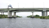
The Thelwall Viaduct is a steel
composite girder
viaduct
in Thelwall
, Warrington
, England
. It carries the M6 motorway
across the Manchester Ship Canal
and the River Mersey
. Its location on the motorway network is between junctions 20 and 21 of the M6, the former being also known as junction 9 of the M56
.
It actually comprises two entirely separate bridge
s, one carrying the northbound carriageway (opened in July 1963) and one the southbound carriageway (opened in 1995). Both viaducts are approximately 1.35 km long, with the longest span being 102.4 m over the Ship Canal.
In July 2002 a failed roller bearing was discovered and it became necessary to close all but one northbound lane. As the M6 at the time carried an estimated 150,000-160,000 vehicles per day, this led to serious congestion. The viaduct was not completely reopened to daytime traffic until February 2005, and subsequently remained partially closed at night for further remedial work to take place. In all, 148 bearings were replaced, with the repair scheme costing around £52 million.
Given the bridge's height and openness to the elements it has frequently been the subject of speed reductions due to strong gusts of wind that badly effect the stability of high sided vehicles. On several occasions lane closures have resulted as a consequence of articulated vehicles simply being blown over. However, the open sides of the bridge are a deliberate design feature to reduce the likelihood of snow drifts building on the carraigeways.
In April 2011 the bridge was the site of a massive Freeparty, with reportedly over 5000 ravers in attendance.
Structural steel
Structural steel is steel construction material, a profile, formed with a specific shape or cross section and certain standards of chemical composition and mechanical properties...
composite girder
Girder bridge
A girder bridge, in general, is a bridge built of girders placed on bridge abutments and foundation piers. In turn, a bridge deck is built on top of the girders in order to carry traffic. There are several different subtypes of girder bridges:...
viaduct
Viaduct
A viaduct is a bridge composed of several small spans. The term viaduct is derived from the Latin via for road and ducere to lead something. However, the Ancient Romans did not use that term per se; it is a modern derivation from an analogy with aqueduct. Like the Roman aqueducts, many early...
in Thelwall
Thelwall
Thelwall is a suburban village in Warrington, North Cheshire, England, close to the Lymm junction of the M6.-Geography:Thelwall nowadays borders the villages of Lymm and Grappenhall, and , Latchford. It is also one of the two principal settlements of Grappenhall and Thelwall civil parish...
, Warrington
Warrington
Warrington is a town, borough and unitary authority area of Cheshire, England. It stands on the banks of the River Mersey, which is tidal to the west of the weir at Howley. It lies 16 miles east of Liverpool, 19 miles west of Manchester and 8 miles south of St Helens...
, England
England
England is a country that is part of the United Kingdom. It shares land borders with Scotland to the north and Wales to the west; the Irish Sea is to the north west, the Celtic Sea to the south west, with the North Sea to the east and the English Channel to the south separating it from continental...
. It carries the M6 motorway
M6 motorway
The M6 motorway runs from junction 19 of the M1 at the Catthorpe Interchange, near Rugby via Birmingham then heads north, passing Stoke-on-Trent, Manchester, Preston, Carlisle and terminating at the Gretna junction . Here, just short of the Scottish border it becomes the A74 which continues to...
across the Manchester Ship Canal
Manchester Ship Canal
The Manchester Ship Canal is a river navigation 36 miles long in the North West of England. Starting at the Mersey Estuary near Liverpool, it generally follows the original routes of the rivers Mersey and Irwell through the historic counties of Cheshire and Lancashire. Several sets of locks lift...
and the River Mersey
River Mersey
The River Mersey is a river in North West England. It is around long, stretching from Stockport, Greater Manchester, and ending at Liverpool Bay, Merseyside. For centuries, it formed part of the ancient county divide between Lancashire and Cheshire....
. Its location on the motorway network is between junctions 20 and 21 of the M6, the former being also known as junction 9 of the M56
M56 motorway
The M56 Motorway, also known as the North Cheshire motorway, is in Cheshire and Greater Manchester, England. It runs from Junction 4 of the M60 to Dunkirk, Cheshire and is in length. It is often busy with long-distance commuter traffic towards North Wales...
.
It actually comprises two entirely separate bridge
Bridge
A bridge is a structure built to span physical obstacles such as a body of water, valley, or road, for the purpose of providing passage over the obstacle...
s, one carrying the northbound carriageway (opened in July 1963) and one the southbound carriageway (opened in 1995). Both viaducts are approximately 1.35 km long, with the longest span being 102.4 m over the Ship Canal.
In July 2002 a failed roller bearing was discovered and it became necessary to close all but one northbound lane. As the M6 at the time carried an estimated 150,000-160,000 vehicles per day, this led to serious congestion. The viaduct was not completely reopened to daytime traffic until February 2005, and subsequently remained partially closed at night for further remedial work to take place. In all, 148 bearings were replaced, with the repair scheme costing around £52 million.
Given the bridge's height and openness to the elements it has frequently been the subject of speed reductions due to strong gusts of wind that badly effect the stability of high sided vehicles. On several occasions lane closures have resulted as a consequence of articulated vehicles simply being blown over. However, the open sides of the bridge are a deliberate design feature to reduce the likelihood of snow drifts building on the carraigeways.
In April 2011 the bridge was the site of a massive Freeparty, with reportedly over 5000 ravers in attendance.