The Jug
Encyclopedia
The Jug — formerly known as the Jug Handle — is a jug-shaped island
formed by a horseshoe bend on Middle Island Creek
near Middlebourne
in Tyler County, West Virginia
. It is maintained by the state of West Virginia as The Jug Wildlife Management Area.

 Middle Island Creek's most extreme meander forms a peninsula
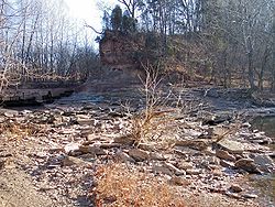
known as "the Jug," located upstream of Middlebourne. The creek rounds a 7 mile (11 km) bend only to return to within 100 feet (30 m) of itself. Sometime prior to 1800, an early European settler named George Gregg had a raceway (mill race)
carved across the narrow point of the peninsula and harnessed the resulting hydropower
of the stream's 13-foot (4 m) fall for a gristmill
and sawmill
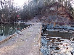
at the site. These mills were destroyed by a flood in 1852; four more mills were subsequently built and respectively washed away by flooding in the later 19th century. Flooding had the effect of widening the raceway across the peninsula such that it became the main channel of the stream, inhibiting the flow of water through the longer loop and transforming the peninsula to an island. In 1947 the West Virginia Conservation Commission constructed a low water bridge
which substantially dammed the cut-through and restored a steady flow to the bend of the creek. The low water bridge is known to be frequently impassible due to flooding. The land encircled by the creek's loop is operated as a Wildlife Management Area by the state of West Virginia.
Island
An island or isle is any piece of sub-continental land that is surrounded by water. Very small islands such as emergent land features on atolls can be called islets, cays or keys. An island in a river or lake may be called an eyot , or holm...
formed by a horseshoe bend on Middle Island Creek
Middle Island Creek
Middle Island Creek is a river, 77 miles long, in northwestern West Virginia, USA. It is a tributary of the Ohio River, draining an area of 565 square miles on the unglaciated Allegheny Plateau...
near Middlebourne
Middlebourne, West Virginia
Middlebourne is a town in Tyler County, West Virginia, USA. The population was 870 at the 2000 census. It is the county seat and was established by an enactment of the Virginia General Assembly in 1813...
in Tyler County, West Virginia
West Virginia
West Virginia is a state in the Appalachian and Southeastern regions of the United States, bordered by Virginia to the southeast, Kentucky to the southwest, Ohio to the northwest, Pennsylvania to the northeast and Maryland to the east...
. It is maintained by the state of West Virginia as The Jug Wildlife Management Area.
History


Peninsula
A peninsula is a piece of land that is bordered by water on three sides but connected to mainland. In many Germanic and Celtic languages and also in Baltic, Slavic and Hungarian, peninsulas are called "half-islands"....
known as "the Jug," located upstream of Middlebourne. The creek rounds a 7 mile (11 km) bend only to return to within 100 feet (30 m) of itself. Sometime prior to 1800, an early European settler named George Gregg had a raceway (mill race)
Mill race
A mill race, raceway or mill lade is the current or channel of a stream, especially one for conducting water to or from a water wheel or other device for utilizing its energy...
carved across the narrow point of the peninsula and harnessed the resulting hydropower
Hydropower
Hydropower, hydraulic power, hydrokinetic power or water power is power that is derived from the force or energy of falling water, which may be harnessed for useful purposes. Since ancient times, hydropower has been used for irrigation and the operation of various mechanical devices, such as...
of the stream's 13-foot (4 m) fall for a gristmill
Gristmill
The terms gristmill or grist mill can refer either to a building in which grain is ground into flour, or to the grinding mechanism itself.- Early history :...
and sawmill
Sawmill
A sawmill is a facility where logs are cut into boards.-Sawmill process:A sawmill's basic operation is much like those of hundreds of years ago; a log enters on one end and dimensional lumber exits on the other end....
at the site. These mills were destroyed by a flood in 1852; four more mills were subsequently built and respectively washed away by flooding in the later 19th century. Flooding had the effect of widening the raceway across the peninsula such that it became the main channel of the stream, inhibiting the flow of water through the longer loop and transforming the peninsula to an island. In 1947 the West Virginia Conservation Commission constructed a low water bridge
Low water crossing
A low water crossing provides a bridge when water flow is low. Under high flow conditions, water runs over the roadway and precludes vehicular traffic...
which substantially dammed the cut-through and restored a steady flow to the bend of the creek. The low water bridge is known to be frequently impassible due to flooding. The land encircled by the creek's loop is operated as a Wildlife Management Area by the state of West Virginia.

