

The Forest of Nisene Marks State Park
Encyclopedia
State park
State parks are parks or other protected areas managed at the federated state level within those nations which use "state" as a political subdivision. State parks are typically established by a state to preserve a location on account of its natural beauty, historic interest, or recreational...
located in Aptos, California
Aptos, California
Aptos is a census-designated place in Santa Cruz County, California, United States. The population was 6,220 at the 2010 census.Aptos is an unincorporated area of Santa Cruz county, consisting of several small communities...
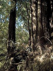
and contains over 40 miles (64.4 km) of hiking trails and fire roads through approximately 10000 acres (40.5 km²) of variable terrain. The park was named for Nisene Marks, a passionate nature lover and the mother of a Salinas farming family that purchased the land from lumber companies (and others), in the hopes of finding oil. Nisene's children donated the 9700 acres (39.3 km²) of land in her memory, to the State of California (with the help of the Nature Conservancy) in 1963 after drilling efforts had failed to find any oil. The California State Parks department, with additional help from the Save-the-Redwoods League
Save-the-Redwoods League
The Save the Redwoods League is an organization dedicated to the protection of the remaining Coast Redwood trees in the state of California. It was founded in 1918 by Frederick Russell Burnham, Madison Grant, John C. Merriam, and Henry Fairfield Osborn....
, expanded the park to 10036 acres (40.6 km²). The park is on land that was clear-cut during a forty-year period of logging (1883-1923) by the Loma Prieta Lumber Company. Visitors can still find evidence of logging operations, mill sites and trestles in the park. The park offers rugged semi-wilderness, rising from sea level to steep coastal mountains of more than 2600 feet (792.5 m). Today the park is a popular spot for running, hiking and horseback riding. Mountain biking is restricted to the fire road as of 2004 because of deed restrictions regarding the state park. Picnic tables and barbecue pits are available. A trail camp is located six miles (10 km) from the nearest parking lot. Dogs are allowed only along the entrance road and in the picnic areas and must be on a leash no longer than six feet at all times. Camping (backpacking) is also available with advance registration.
The epicenter
Epicenter
The epicenter or epicentre is the point on the Earth's surface that is directly above the hypocenter or focus, the point where an earthquake or underground explosion originates...
of the October 17, 1989, Loma Prieta earthquake
Loma Prieta earthquake
The Loma Prieta earthquake, also known as the Quake of '89 and the World Series Earthquake, was a major earthquake that struck the San Francisco Bay Area of California on October 17, 1989, at 5:04 p.m. local time...
was in this park. (37.03° N 121.88° W)
The quake's epicenter and Five Finger Falls are the two most popular attractions in the park. But in early 2007, there was landslide on Aptos Creek Trail which leads to Five Finger Falls and the trail was closed. The waterfall is still reachable by a longer route, via the Big Slide trail.