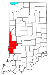
Terre Haute, IN Metropolitan Statistical Area
Encyclopedia

United States metropolitan area
In the United States a metropolitan statistical area is a geographical region with a relatively high population density at its core and close economic ties throughout the area. Such regions are not legally incorporated as a city or town would be, nor are they legal administrative divisions like...
(MSA) in the United States
United States
The United States of America is a federal constitutional republic comprising fifty states and a federal district...
. Centering around the city of Terre Haute
Terre Haute, Indiana
Terre Haute is a city and the county seat of Vigo County, Indiana, United States, near the state's western border with Illinois. As of the 2010 census, the city had a total population of 60,785 and its metropolitan area had a population of 170,943. The city is the county seat of Vigo County and...
, it was originally formed by the United States Census Bureau
United States Census Bureau
The United States Census Bureau is the government agency that is responsible for the United States Census. It also gathers other national demographic and economic data...
in 1950 and consisted of Vigo County
Vigo County, Indiana
Vigo County is a county located along the western border of the U.S. state of Indiana. Vigo County is included in the Terre Haute, Indiana, Metropolitan Statistical Area. The county seat is Terre Haute....
. As surrounding counties saw an increase in their population densities and the number of their residents employed within Vigo County, they met Census criteria to be added to the MSA. Four Indiana
Indiana
Indiana is a US state, admitted to the United States as the 19th on December 11, 1816. It is located in the Midwestern United States and Great Lakes Region. With 6,483,802 residents, the state is ranked 15th in population and 16th in population density. Indiana is ranked 38th in land area and is...
counties
County
A county is a jurisdiction of local government in certain modern nations. Historically in mainland Europe, the original French term, comté, and its equivalents in other languages denoted a jurisdiction under the sovereignty of a count A county is a jurisdiction of local government in certain...
are now a part of this MSA.
| Geographic Area | July 1, 2005 | 2000 Census United States Census, 2000 The Twenty-second United States Census, known as Census 2000 and conducted by the Census Bureau, determined the resident population of the United States on April 1, 2000, to be 281,421,906, an increase of 13.2% over the 248,709,873 persons enumerated during the 1990 Census... |
1990 Census United States Census, 1990 The Twenty-first United States Census, conducted by the Census Bureau, determined the resident population of the United States to be 248,709,873, an increase of 9.8 percent over the 226,545,805 persons enumerated during the 1980 Census.... |
1980 Census United States Census, 1980 The Twentieth United States Census, conducted by the Census Bureau, determined the resident population of the United States to be 226,545,805, an increase of 11.4 percent over the 203,184,772 persons enumerated during the 1970 Census.-Census questions:... |
1970 Census United States Census, 1970 The Nineteenth United States Census, conducted by the Census Bureau, determined the resident population of the United States to be 203,392,031, an increase of 13.4 percent over the 179,323,175 persons enumerated during the 1960 Census.-Data availability:... |
1960 Census United States Census, 1960 The Eighteenth United States Census, conducted by the Census Bureau, determined the resident population of the United States to be 179,323,175, an increase of 18.5 percent over the 151,325,798 persons enumerated during the 1950 Census.-Census questions:... |
1950 Census United States Census, 1950 The Seventeenth United States Census, conducted by the Census Bureau, determined the resident population of the United States to be 150,697,361, an increase of 14.5 percent over the 131,669,275 persons enumerated during the 1940 Census.-Census questions:... |
|---|---|---|---|---|---|---|---|
| Terre Haute MSA | 168,059 | 170,943 | 130,812 | 176,583 | 175,143 | 108,458 | 105,160 |
| Clay County Clay County, Indiana Clay County is a county located in the U.S. state of Indiana. As of 2010, the population was 26,890. The county seat is Brazil. Clay County is included in the Terre Haute, Indiana, Metropolitan Statistical Area.- History :Clay County was formed in 1825... |
27,142 | 26,556 | 24,705 | 24,862 | 23,933 | 24,207¹ | 23,918¹ |
| Sullivan County Sullivan County, Indiana Sullivan County is a county located in the U.S. state of Indiana, and determined by the U.S. Census Bureau to include the mean center of U.S. population in 1940. As of 2010, the population was 21,475. The county seat is Sullivan. Sullivan County is included in the Terre Haute, Indiana,... |
21,763 | 21,751 | 18,993¹ ³ | 21,107 | 19,889 | 21,721¹ | 23,667¹ |
| Vermillion County Vermillion County, Indiana Vermillion County lies in western Indiana between the Illinois border and the Wabash River. It was officially established in 1824 and was the 50th Indiana county to be formed. It is included in the Terre Haute, Indiana, Metropolitan Statistical Area. The county seat is Newport.According to the 2010... |
16,562 | 16,788 | 16,773¹ ² | 18,229 | 16,793 | 17,683¹ | 19,723¹ |
| Vigo County Vigo County, Indiana Vigo County is a county located along the western border of the U.S. state of Indiana. Vigo County is included in the Terre Haute, Indiana, Metropolitan Statistical Area. The county seat is Terre Haute.... |
102,592 | 105,848 | 106,107 | 112,385 | 114,528 | 108,458 | 105,160 |
1. County was not a part of Terre Haute, IN MSA at the time of this census and the county's population is not included in MSA total.
2. County placed back into MSA in 1993.
3. County placed back into MSA in 2000.

