
Temascalcingo
Encyclopedia
Temascalcingo de José Maria Velasco is a town and seat of the municipality
of Temascalcingo in the State of Mexico, Mexico
. It is located in the northeast of the state. The temazcal
was very common in Temascalcingo. The name Temascalcingo has its roots in Nahuatl
. It means place of the little temazcal. The town is one of the "Pueblo con Encanto" (Towns with Charm) of the State of Mexico.
. The earliest known inhabitands of the area were the Mazahua
. It was originally called "Ñiñi Mbate" which probably means 'place of the small plain' but possibly 'place of the first man'. This area was conquered by the Aztecs before the 16th century, and its last Aztec governor was named Ocoyotzen. When the Spanish invaded, the Mazahuas and the Otomis of this area united with the Aztecs to fight them. However, after the Spanish victory, Hernán Cortés
distributed this area, along with Metepec
to Francisco de Villegas in 1540. In 1535, the Franciscans began evangelization here, establishing churches and renaming the area, San Miguel Temascalcingo. Through the 18th century, haciendas here grew to supply grain to mining areas like Tlalpujahua
and El Oro. Because of a history of mistreatment by colonial authorities, the residents here sided early with Hidalgo when the Mexican War of Independence
broke out in 1810. Shortly after the end of the war, the State of Mexico was created in 1824 and the municipality of Temascalcingo in 1825, with San Miguel Temascalcingo as the seat. This area was the scene of a destructive earthquake in 1912. As the birthplace of the painter José Maria Velasco, the town changed its name to Temascalcingo de José Maria Velasco July 14, 1945 by decree. However, it is still commonly referred to simply as "Temascalcingo". In 1988, a group of residents from Tepeolulco, a community under Temascalcingo's jurisdiction, took over the municipal hall to protest water supplies and civil rights violations.
To the west of the main plaza is the Parish of San Miguel Arcángel. This church was rebuilt in 1939 in Neoclassic style, mostly imitating the design of the Church of El Carmen in Celaya, Guanajuato. It was built with pink stone that is found in this region. It has only one tower, with contains a clock. Its interior altarpieces are all done in mahogany by sculptor Fidel Enriquez Perez. In front of the church is a large atrium park.
The Centro Cultural José Maria Velazquez, on Hermanos Velasquez Street, is dedicated to the art of this landscape painter. Most of Velazquez's themes reside in botany and in nature, but he is best known for the landscapes he painted of areas in central Mexico. Also in his honor is the José Maria Velazquez Nature Park, located at the main entrance to the town. This is a section of forest that offers some amenities such as kiosks, playgrounds, and a small pool.
From December 31 to January 1, Mazahua and Otomi pilgrims come here to celebrate the "Lord of the Coronation," carrying their images of this saint adorned with flowers, fruit and bread, accompanied by flutes, mariachis or drums. Local dances such as "Las Pastoras," "Los Concheros," "Los Macheteros," "Los Romanos" and "Los Chimales" are performed. At midday on January 1, there is a procession to the church. On Jan 2, men on horseback arrive here in honor of the image here of Saint Francis of Assisi.
The passion play
held every year since 1975, whose script was written by Amalio Quintana. During this Passion Play, young men re-enact the crucifixion of Christ. The Feast of Corpus Christi is celebrated in June with large processions as well. A more locally-derived festival occurs on the 16th of August, in honor of "Lord Ndareje" or "Lord of the Water." Prehispanic rites occur at the Los Pastores waterfall and offerings are left in the Lerma River.
, (1840–1912) who was a painter of landscapes, Archbishop Leopoldo Ruiz y Flores, (1865–1941) suffered the exile three times during the Cristero movement in Mexico, María del Carmen Garduño Cervantes,(1955- ) a track-and-field athlete who has won medals in the PanAmerican Games and set Mexican records, and Pinito Reynoso Bejarano (1895–1981) and educator best known for his work against illiteracy.
, Jocotitlán
and El Oro, and to the west by the states of Michoacán
and Querétaro
. The population of the entire municipality in 2005 was 58,169 people.
Two notable sites in and near the municipal seat are the Tzindo, which is an archeological zone where there are some cave drawings. From Colonial period there is the Hacienda
de Solis. Located about 18 km from the municipal seat, the largest attraction here is officially called the "Spring of Jesus," but is more commonly known as "El Borbollón," (the gusher). It is a natural spring of volcanically-heated water which forms a pool of water with a high mineral content.
Municipality
A municipality is essentially an urban administrative division having corporate status and usually powers of self-government. It can also be used to mean the governing body of a municipality. A municipality is a general-purpose administrative subdivision, as opposed to a special-purpose district...
of Temascalcingo in the State of Mexico, Mexico
Mexico
The United Mexican States , commonly known as Mexico , is a federal constitutional republic in North America. It is bordered on the north by the United States; on the south and west by the Pacific Ocean; on the southeast by Guatemala, Belize, and the Caribbean Sea; and on the east by the Gulf of...
. It is located in the northeast of the state. The temazcal
Temazcal
A temazcal is a type of sweat lodge which originated with pre-Hispanic Indigenous peoples in Mesoamerica. The word temazcal comes from the Nahuatl word temazcalli , or possibly from the Aztec teme and calli . Temazcal in English is also written as temezcal, temascal, or temescal...
was very common in Temascalcingo. The name Temascalcingo has its roots in Nahuatl
Nahuatl
Nahuatl is thought to mean "a good, clear sound" This language name has several spellings, among them náhuatl , Naoatl, Nauatl, Nahuatl, Nawatl. In a back formation from the name of the language, the ethnic group of Nahuatl speakers are called Nahua...
. It means place of the little temazcal. The town is one of the "Pueblo con Encanto" (Towns with Charm) of the State of Mexico.
History
The earliest settlements in the area go back over 10,000 years and are situated near what is today the Lerma RiverLerma River
The Lerma Santiago River is Mexico's second longest river. It is a river in west-central Mexico that begins in Mexican Plateau at an altitude over above sea level, and ends where it empties into Lake Chapala, Mexico's largest lake, near Guadalajara, Jalisco...
. The earliest known inhabitands of the area were the Mazahua
Mazahua
The Mazahua are an indigenous people of Mexico, inhabiting the northwestern portion of the State of Mexico and northeastern area of Michoacán, with a presence also in the Federal District owing to recent migration...
. It was originally called "Ñiñi Mbate" which probably means 'place of the small plain' but possibly 'place of the first man'. This area was conquered by the Aztecs before the 16th century, and its last Aztec governor was named Ocoyotzen. When the Spanish invaded, the Mazahuas and the Otomis of this area united with the Aztecs to fight them. However, after the Spanish victory, Hernán Cortés
Hernán Cortés
Hernán Cortés de Monroy y Pizarro, 1st Marquis of the Valley of Oaxaca was a Spanish Conquistador who led an expedition that caused the fall of the Aztec Empire and brought large portions of mainland Mexico under the rule of the King of Castile in the early 16th century...
distributed this area, along with Metepec
Metepec
Metepec is a city and municipality in the State of Mexico in Mexico and is located directly to the east of the state capital, Toluca, at an altitude of 2,635 metres above sea level. The centre of Mexico City lies some 50 km further to the east. The name Metepec comes from Náhuatl meaning hill of...
to Francisco de Villegas in 1540. In 1535, the Franciscans began evangelization here, establishing churches and renaming the area, San Miguel Temascalcingo. Through the 18th century, haciendas here grew to supply grain to mining areas like Tlalpujahua
Tlalpujahua
Tlalpujahua is a town and municipality located in the far northeast of the state of Michoacán in central Mexico. It is a former mining town, home of the Dos Estrellas Mine, which was the leading producer of gold in the early 20th century...
and El Oro. Because of a history of mistreatment by colonial authorities, the residents here sided early with Hidalgo when the Mexican War of Independence
Mexican War of Independence
The Mexican War of Independence was an armed conflict between the people of Mexico and the Spanish colonial authorities which started on 16 September 1810. The movement, which became known as the Mexican War of Independence, was led by Mexican-born Spaniards, Mestizos and Amerindians who sought...
broke out in 1810. Shortly after the end of the war, the State of Mexico was created in 1824 and the municipality of Temascalcingo in 1825, with San Miguel Temascalcingo as the seat. This area was the scene of a destructive earthquake in 1912. As the birthplace of the painter José Maria Velasco, the town changed its name to Temascalcingo de José Maria Velasco July 14, 1945 by decree. However, it is still commonly referred to simply as "Temascalcingo". In 1988, a group of residents from Tepeolulco, a community under Temascalcingo's jurisdiction, took over the municipal hall to protest water supplies and civil rights violations.
The town today
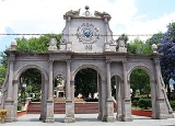
The town today has an altitude of 2,380 meters and in 2005 had a population of 11,454 people. The town is centered on a square called the Plaza Centenario, with its Municipal Palace to the south of the square. To the north is another, smaller square dedicated to painter José Mara Velazquez.ref name="MexDesGuia">To the west of the main plaza is the Parish of San Miguel Arcángel. This church was rebuilt in 1939 in Neoclassic style, mostly imitating the design of the Church of El Carmen in Celaya, Guanajuato. It was built with pink stone that is found in this region. It has only one tower, with contains a clock. Its interior altarpieces are all done in mahogany by sculptor Fidel Enriquez Perez. In front of the church is a large atrium park.
The Centro Cultural José Maria Velazquez, on Hermanos Velasquez Street, is dedicated to the art of this landscape painter. Most of Velazquez's themes reside in botany and in nature, but he is best known for the landscapes he painted of areas in central Mexico. Also in his honor is the José Maria Velazquez Nature Park, located at the main entrance to the town. This is a section of forest that offers some amenities such as kiosks, playgrounds, and a small pool.
Food and festivities
Local dishes include chicken in "chirrión" sauce, "charales con nopales, cactus in green salsa, and "mole de olla" with xoconostles (a type of fruit). Local drinks include "puscua," a drink made from corn, "sende choo," a Mazahua drink made from fermented corn and pulque, which is often served flavored with fruit such as cactus pears.From December 31 to January 1, Mazahua and Otomi pilgrims come here to celebrate the "Lord of the Coronation," carrying their images of this saint adorned with flowers, fruit and bread, accompanied by flutes, mariachis or drums. Local dances such as "Las Pastoras," "Los Concheros," "Los Macheteros," "Los Romanos" and "Los Chimales" are performed. At midday on January 1, there is a procession to the church. On Jan 2, men on horseback arrive here in honor of the image here of Saint Francis of Assisi.
The passion play
Passion play
A Passion play is a dramatic presentation depicting the Passion of Jesus Christ: his trial, suffering and death. It is a traditional part of Lent in several Christian denominations, particularly in Catholic tradition....
held every year since 1975, whose script was written by Amalio Quintana. During this Passion Play, young men re-enact the crucifixion of Christ. The Feast of Corpus Christi is celebrated in June with large processions as well. A more locally-derived festival occurs on the 16th of August, in honor of "Lord Ndareje" or "Lord of the Water." Prehispanic rites occur at the Los Pastores waterfall and offerings are left in the Lerma River.
Notable residents
Some notable people from this town include: José Maria VelascoJosé María Velasco
José María Velasco may refer to:*José María Velasco Gómez, 19th century Mexican painter*José María Velasco Ibarra , president of Ecuador*José María Velasco, México, city in Mexican state of Edomex...
, (1840–1912) who was a painter of landscapes, Archbishop Leopoldo Ruiz y Flores, (1865–1941) suffered the exile three times during the Cristero movement in Mexico, María del Carmen Garduño Cervantes,(1955- ) a track-and-field athlete who has won medals in the PanAmerican Games and set Mexican records, and Pinito Reynoso Bejarano (1895–1981) and educator best known for his work against illiteracy.
The municipality
As municipal seat, the town of Temascalcingo de José Maria Velasco has governing jurisdiction over the following communities: Ahuacatitlan Centro, Boshesda, Calderas, Cerritos de Cárdenas, Barrio de Corona, Guadalupe Ixtapa, La Huerta, Juanacatlán, La Magdalena, Mesa de Bañi, Mesa de Santiago (La Mesa), Pastores Primer Barrio, Puruahua, Pueblo Nuevo Solís (La Estancia), San Antonio Solís, San Francisco Solís, San Francisco Tepeolulco, San José Ixtapa, San José Solís, San Juanico el Alto (San Juanico), San Mateo el Viejo, San Miguel Solís, San Nicolás Solís, San Pedro el Alto, San Pedro Potla Centro (San Pedro Potla), Santa Ana Yenshu Centro, Santa Lucía (Ejido de San Mateo el Viejo), Santa María Canchesda, Santa María Solís, Santa Rosa Solís, Santiago Coachochitlán, San Vicente Solís, Ex-hacienda de Solís, El Tejocote (La Loma), Santa Ana Yenshu Ejido, San Pedro Potla Segundo Barrio, San Pedro Potla Primer Barrio Ejido, San José los Reyes, El Rodeo, Cuadrilla, Ahuacatitlán (La Providencia), Barrio de Shelle, Estación Solís (Estación Alberto Garduño), El Garay, La Mesa del Venado, Pozo de las Palomas, San Juanico Centro, San Pedro Potla Tercer Barrio, Santa Ana Yenshu la Mesa, Los Pinos, La Estanzuela, Ixtapa, Mesa de Bombaro, Mesa de los Garnica, Mogote de la Campana, Barrio las Peñas, Barrio Santa María los Chamacueros, San Fco. Tepeolulco, Tercer Barrio la Mesa, La Magdalena Bosha, La Magdalena Cruz Blanca, Santiago Coachochitlán Barrio del Rincón, Los Pastores (Pastores Segundo Barrio), San Pedro de la Loma, and La Loma de San Mateo. Temascalcingo is bordered by the municipalities of Acambay, AtlacomulcoAtlacomulco
Atlacomulco is a city and municipality located in the northwest of the State of Mexico in central Mexico, 63 km from the state capital of Toluca. The name is derived from the Nahuatl phrase "atlacomulli" which means "where there are wells." The city, with a population of 20,477 is...
, Jocotitlán
Jocotitlán
Jocotitlán is a town and municipality located in the northwestern part of the State of Mexico on the central highlands of the country of Mexico. The town is located at the foot of the Jocotitlán or Xocotépetl volcano, while most of the rest of the municipality is in the Ixtlahuaca Valley...
and El Oro, and to the west by the states of Michoacán
Michoacán
Michoacán officially Estado Libre y Soberano de Michoacán de Ocampo is one of the 31 states which, with the Federal District, comprise the 32 Federal Entities of Mexico. It is divided in 113 municipalities and its capital city is Morelia...
and Querétaro
Querétaro
Querétaro officially Estado Libre y Soberano de Querétaro de Arteaga is one of the 31 states which, with the Federal District, comprise the 32 Federal Entities of Mexico. It is divided into 18 municipalities and its capital city is Santiago de Querétaro....
. The population of the entire municipality in 2005 was 58,169 people.
Two notable sites in and near the municipal seat are the Tzindo, which is an archeological zone where there are some cave drawings. From Colonial period there is the Hacienda
Hacienda
Hacienda is a Spanish word for an estate. Some haciendas were plantations, mines, or even business factories. Many haciendas combined these productive activities...
de Solis. Located about 18 km from the municipal seat, the largest attraction here is officially called the "Spring of Jesus," but is more commonly known as "El Borbollón," (the gusher). It is a natural spring of volcanically-heated water which forms a pool of water with a high mineral content.