

Telopea, New South Wales
Encyclopedia
Suburb
The word suburb mostly refers to a residential area, either existing as part of a city or as a separate residential community within commuting distance of a city . Some suburbs have a degree of administrative autonomy, and most have lower population density than inner city neighborhoods...
of Sydney
Sydney
Sydney is the most populous city in Australia and the state capital of New South Wales. Sydney is located on Australia's south-east coast of the Tasman Sea. As of June 2010, the greater metropolitan area had an approximate population of 4.6 million people...
, in the state of New South Wales
New South Wales
New South Wales is a state of :Australia, located in the east of the country. It is bordered by Queensland, Victoria and South Australia to the north, south and west respectively. To the east, the state is bordered by the Tasman Sea, which forms part of the Pacific Ocean. New South Wales...
, Australia
Australia
Australia , officially the Commonwealth of Australia, is a country in the Southern Hemisphere comprising the mainland of the Australian continent, the island of Tasmania, and numerous smaller islands in the Indian and Pacific Oceans. It is the world's sixth-largest country by total area...
. Telopea is located 23 kilometres north-west of the Sydney central business district
Sydney central business district
The Sydney central business district is the main commercial centre of Sydney, New South Wales, Australia. It extends southwards for about 3 kilometres from Sydney Cove, the point of first European settlement. Its north–south axis runs from Circular Quay in the north to Central railway station in...
, in the local government area of the City of Parramatta
City of Parramatta
The City of Parramatta is a Local Government Area in western Sydney, in the state of New South Wales, Australia.Initially in 1861 it was formed as Municipality of Parramatta...
.
Name
Telopea is named from Telopea speciosissimaTelopea speciosissima
Telopea speciosissima, commonly known as the New South Wales waratah or simply waratah, is a large shrub in the plant family Proteaceae. It is endemic to New South Wales in Australia and is the floral emblem of that state...
, the New South Wales waratah, a plant that was abundant in the area before it was colonised and which became the floral emblem of New South Wales.
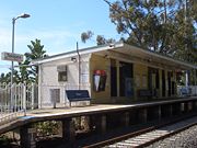
Transport
Telopea railway station is on the Carlingford line of the CityRailCityRail
CityRail is an operating brand of RailCorp, a corporation owned by the state government of New South Wales, Australia. It is responsible for providing commuter rail services, and some coach services, in and around Sydney, Newcastle and Wollongong, the three largest cities of New South Wales. It is...
network. The suburb is bordered by Kissing Point Road to the south and Pennant Hills Road to the north.
Commercial area
Waratah Shopping Centre, located on Benaud Place, has many retail shops including a Franklins supermarket, newsagent, chemist, and a hair and beauty salon. A small group of shops is also located opposite the railway station on Adderton Road.Housing
Telopea is mainly low to low-medium density housing with most of the dwellings been built after the Second World War. The suburb is bisected by the Carlingford railway line with most of the medium density housing lying adjacent to the train line.Parks
Telopea contains a large tract of bushland on its western edge, backing onto the Oatlands golf course. The bushland, the Vineyard Creek Reserve as it is known contains a spring-fed creek and has several waterfalls on its course before it disappears beneath Kissing Point road to the south. The creek and the bushland are protected as environmental areas.Churches
- The local Anglican Church meets in Telopea on Saturday evenings and at Dundas on Sundays.
- Telopea Christian Centre is another local Church.