
Teknaf Upazila
Encyclopedia

Cox's Bazar District
Cox's Bazar District is a district in the Chittagong Division of Bangladesh. It is named after Cox's Bazar, which is one of the world's longest natural sea beaches . It is located south of Chittagong. Cox's Bazar is also known by the name Panowa . Another old name was Palongkee...
in the Division of Chittagong, Bangladesh
Bangladesh
Bangladesh , officially the People's Republic of Bangladesh is a sovereign state located in South Asia. It is bordered by India on all sides except for a small border with Burma to the far southeast and by the Bay of Bengal to the south...
. It forms the southernmost point in mainland Bangladesh
Bangladesh
Bangladesh , officially the People's Republic of Bangladesh is a sovereign state located in South Asia. It is bordered by India on all sides except for a small border with Burma to the far southeast and by the Bay of Bengal to the south...
(St. Martin's Island
St. Martin's Island
St. Martin's Island is a small island in the northheast part of the Bay of Bengal, about 9 km south of the tip of the Cox's Bazar-Teknaf peninsula, and forming the southernmost part of Bangladesh. It is not a coral island in Bangladesh. It is about 8 km west of the northwest coast of...
is the southernmost point). The name of the region comes from the Naf River
Naf River
Naf River It is an elongated estuary in the extreme southeast of Cox's Bazar district dividing the district from Arakan, Myanmar. It rises in the Arakan hills on the southeastern borders of the district and flows into the Bay of Bengal. Its width varies from 1.61 km to 3.22 km. The river...
which forms the Eastern boundary of the upazila.
Geography
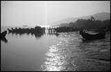
Teknaf is located at 20.8667°N 92.3000°E . It has 23675 units of house hold and total area 388.68 km².The tidal range at the Teknaf coastal area is strong influenced Naaf river estuary. The area is blessed with a warm tropical climate and sufficient rainfall which enable to support a wide biological diversity.
Demographics
As of the 1991 Bangladesh census1991 Bangladesh census
In 1991, the Bangladesh Bureau of Statistics, conducted a national census in Bangladesh. They recorded data from all of the districts and upazilas and main cities in Bangladesh including statistical data on population size, households, sex and age distribution, marital status, economically active...
, Teknaf has a population of 152557. Males constitute are 51.81% of the population, and females 48.19%. This Upazila's eighteen up population is 64417. Teknaf has an average literacy rate of 16.6% (7+ years), and the national average of 32.4% literate.
Attractions
Teknaf is the most southern or south-eastern coastal subdistrictSubdistrict
Subdistrict is a low level administrative division of a country. In Thailand it may refer to the King Amphoe or to the Tambon. In England and Wales it was part of a Registration district....
under the Cox's Bazar district of Bangladesh. This is the only place Bangladesh which is connected with Myanmar
Myanmar
Burma , officially the Republic of the Union of Myanmar , is a country in Southeast Asia. Burma is bordered by China on the northeast, Laos on the east, Thailand on the southeast, Bangladesh on the west, India on the northwest, the Bay of Bengal to the southwest, and the Andaman Sea on the south....
(former Burma) by a small river called Naf River
Naf River
Naf River It is an elongated estuary in the extreme southeast of Cox's Bazar district dividing the district from Arakan, Myanmar. It rises in the Arakan hills on the southeastern borders of the district and flows into the Bay of Bengal. Its width varies from 1.61 km to 3.22 km. The river...
of Bangladesh. Because of its geographical location this subdistrict has developed as most interesting place for the foreign and local tourists. Because of tropical weather of Bangladesh most tourists usually go to visit this place during winter or in between winter and autumn (October to March). It is about 90 km far away from Cox's Bazar and well connected with various kinds transportation services.Nilla is one of the best union of teknaf. AL FALAH ACADEMY is one of the best institution of Nila.
Teknaf Peninsula is one of the longest sandy beach ecosystems (80 km) in the world. It represents a transitional ground for the fauna of the Indo-Himalayan and Indo-Malayan ecological sub-regions. Important habitats at the site include mangrove, mudflats, beaches and sand dunes, canals and lagoons and marine habitat. Mangrove forest occurs in Teknaf peninsula both as natural forest with planted stands and mostly distributed in the intertidal zone. the Teknaf peninsula mangroves supports the habitat of 161 different fisheries species (Chowdhury et al, 2011).