

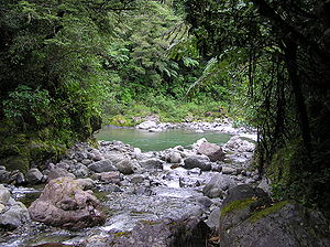
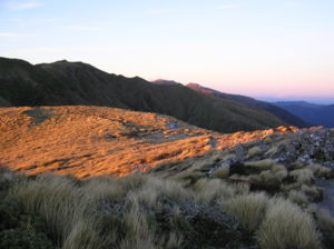
Tararua Range
Encyclopedia
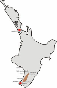
North Island
The North Island is one of the two main islands of New Zealand, separated from the much less populous South Island by Cook Strait. The island is in area, making it the world's 14th-largest island...
of New Zealand
New Zealand
New Zealand is an island country in the south-western Pacific Ocean comprising two main landmasses and numerous smaller islands. The country is situated some east of Australia across the Tasman Sea, and roughly south of the Pacific island nations of New Caledonia, Fiji, and Tonga...
which form a ridge running parallel with the east coast of the island between East Cape
East Cape
East Cape is the easternmost point of the main islands of New Zealand. It is located to the north of Gisborne in the northeast of the North Island....
and Wellington
Wellington
Wellington is the capital city and third most populous urban area of New Zealand, although it is likely to have surpassed Christchurch due to the exodus following the Canterbury Earthquake. It is at the southwestern tip of the North Island, between Cook Strait and the Rimutaka Range...
.
The ridge is at its most pronounced in the southern part of the island, where it comprises the Rimutaka
Rimutaka Range
The Rimutaka Range is one of several mountain ranges in the North Island of New Zealand which form a ridge running parallel with the east coast of the island between East Cape and Wellington.The ridge is at its most pronounced in the southern part of the island, where it consists of the Ruahine,...
, Ruahine
Ruahine Range
The Ruahine Range is one of several mountain ranges in the North Island of New Zealand which form a ridge running parallel with the east coast of the island between East Cape and Wellington....
, and Tararua Ranges.
The Tararuas run northeast-southwest for 80 kilometres from near Palmerston North
Palmerston North
Palmerston North is the main city of the Manawatu-Wanganui region of the North Island of New Zealand. It is an inland city with a population of and is the country's seventh largest city and eighth largest urban area. Palmerston North is located in the eastern Manawatu Plains near the north bank...
to the upper reaches of the Hutt Valley, where the northern tip of the Rimutaka Range begins. It is separated in the north from the southern end of the Ruahine Range by the Manawatu Gorge
Manawatu Gorge
The Manawatu Gorge runs between the Ruahine and Tararua Ranges of the North Island of New Zealand, linking the Manawatu and Hawke's Bay regions...
.
The highest peak in the Tararuas is Mitre
Mitre, New Zealand
Mitre is the highest mountain of the Tararua Range, situated in the lower North Island of New Zealand. It has a total height of .The mountain was named after its double peak that resembles a bishop's mitre.-References:...
(not to be confused with Mitre Peak
Mitre Peak (New Zealand)
Mitre Peak is an iconic mountain in the South Island of New Zealand. It is one of the most photographed peaks in the country.The distinctive shape of the peak in southern New Zealand gives the mountain its name, after the mitre headwear of Christian bishops. It was named by a survey crew from the...
) at 1570 metres (5,150.9 ft). Other prominent peaks include Mount Bannister (1537 metres (5,042.7 ft)) and Mount Hector
Mount Hector, New Zealand
Mount Hector is the highest mountain of the southern Tararua Range, situated in the lower North Island of New Zealand. It has a height of .The mountain is named after James Hector a leading scientist in New Zealand during the 19th century.-References:...
(1529 metres (5,016.4 ft)).
Roads
The only all-weather road right across the range is the "Pahiatua Track", which joins Palmerston NorthPalmerston North
Palmerston North is the main city of the Manawatu-Wanganui region of the North Island of New Zealand. It is an inland city with a population of and is the country's seventh largest city and eighth largest urban area. Palmerston North is located in the eastern Manawatu Plains near the north bank...
and Pahiatua
Pahiatua
Pahiatua is a rural service town in the south-eastern North Island of New Zealand with an urban and rural population of over 4,000. It is between Masterton and Woodville on State Highway 2 and the Wairarapa Line railway, north of Masterton and east of Palmerston North...
and is much used when the Manawatu Gorge
Manawatu Gorge
The Manawatu Gorge runs between the Ruahine and Tararua Ranges of the North Island of New Zealand, linking the Manawatu and Hawke's Bay regions...
road is closed.
Recreation
The Tararua Ranges serve as a popular tramping location for the greater Wellington district. Amongst the available tracks is the well known "Southern CrossingSouthern Crossing
The Southern Crossing is the name of a tramping track in New Zealand's Tararua Range. The track is approximately 32 kilometres long and typically takes between 2–3 days to complete...
" running from Otaki Forks in the west, over Mount Hector and exiting via Kaitoke
Kaitoke
Kaitoke, part of Upper Hutt City, is a locality in the southern North Island of New Zealand. It is located at the northern end of the Hutt Valley, 45 kilometres northeast of Wellington City and six kilometres from the northern end of the Upper Hutt urban area...
.