
Taputeranga Marine Reserve
Encyclopedia
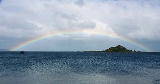
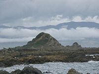
Taputeranga Marine Reserve is a legally protected area of sea and coast along the southern edge of Wellington
City, in New Zealand
. It was officially opened in September 2008.
The Department of Conservation initially proposed the possibility of a marine reserve on the Wellington coast in the late 1980s, but left the idea to concentrate on a Kapiti marine reserve. The main work began in 1991 when the community coalition decided to advance the idea.
The south coast is also blessed with complex undersea landforms that combine with the high energy currents to create many types of habitat.
Wellington
Wellington is the capital city and third most populous urban area of New Zealand, although it is likely to have surpassed Christchurch due to the exodus following the Canterbury Earthquake. It is at the southwestern tip of the North Island, between Cook Strait and the Rimutaka Range...
City, in New Zealand
New Zealand
New Zealand is an island country in the south-western Pacific Ocean comprising two main landmasses and numerous smaller islands. The country is situated some east of Australia across the Tasman Sea, and roughly south of the Pacific island nations of New Caledonia, Fiji, and Tonga...
. It was officially opened in September 2008.
Location and area
The reserve covers 854 hectares and includes all foreshore up to “mean high water spring.” The boundaries are shown on the map, hereOrigins
The application for a reserve came from a community coalition—the South Coast Marine Reserve Coalition and the New Zealand Royal Forest & Bird Protection Society Inc.The Department of Conservation initially proposed the possibility of a marine reserve on the Wellington coast in the late 1980s, but left the idea to concentrate on a Kapiti marine reserve. The main work began in 1991 when the community coalition decided to advance the idea.
Attributes
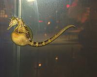
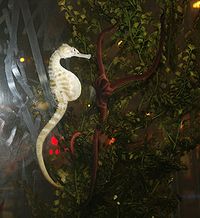
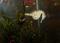
Wellington’s south coast is a great location for a marine reserve for two main reasons. First, it has great natural values, a unique collection of ecological qualities. The reserve would be on the doorstep of the capital city, putting it within easy reach of more than 150,000 people and several marine science institutions. The area has been the focus of extensive scientific research for the past 20~30 years. The coast’s natural values arise in part from the collision of three oceanic currents. The result is a rich and varied mix of plants and animals that thrive in a “soup” of cold sub-Antarctic and warm Pacific waters. The mix of plants and animals is unique in New ZealandThe south coast is also blessed with complex undersea landforms that combine with the high energy currents to create many types of habitat.
See also
- Island Bay
- Te Raekaihau PointTe Raekaihau PointTe Raekaihau Point is a rugged coastal landform in Wellington, New Zealand, adjacent to Princess Bay, between Houghton Bay to the west and Lyall Bay to the east on the south coast. One meaning of the name is "the headland that eats the wind"...
- Tapu Te Ranga MaraeTapu Te Ranga MaraeTapu Te Ranga Marae is a "living" marae in Island Bay, Wellington, New Zealand. It is the home of author Bruce Stewart, his family and various friends. The Marae is listed as a heritage site....
- KaitiakiKaitiakiKaitiaki is a New Zealand term used for the Māori concept of guardianship, for the sky, the sea, and the land. A kaitiaki is a guardian, and the process and practices of protecting and looking after the environment are referred to as kaitiakitanga and include rāhui and tapuThe term kaitiaki is also...
- Ngāti ToaNgati ToaNgāti Toa , an iwi , traces its descent from the eponymous ancestor Toarangatira. The Ngāti Toa region extends from Miria-te-kakara at Rangitikei to Wellington, and across Cook Strait to Wairau and Nelson....
External links
- Department of Conservation - Taputeranga Marine Reserve