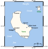
Tanna
Overview
Tanna is an island
of Vanuatu
. It is 40 km (25 mi) long and 19 km (12 mi) wide, with a total area of 550 km² (212 sq mi). Its highest point is the 1,084 m (3,556 ft) summit of Mount Tukosmera
in the south of the island. In the east, northeast of the peak, close to the coast, is where Siwi Lake was located until mid April 2000 when, following unusually heavy rain, the lake burst down the valley into Sulphur Bay
, destroying the village with no loss of life.
Island
An island or isle is any piece of sub-continental land that is surrounded by water. Very small islands such as emergent land features on atolls can be called islets, cays or keys. An island in a river or lake may be called an eyot , or holm...
of Vanuatu
Vanuatu
Vanuatu , officially the Republic of Vanuatu , is an island nation located in the South Pacific Ocean. The archipelago, which is of volcanic origin, is some east of northern Australia, northeast of New Caledonia, west of Fiji, and southeast of the Solomon Islands, near New Guinea.Vanuatu was...
. It is 40 km (25 mi) long and 19 km (12 mi) wide, with a total area of 550 km² (212 sq mi). Its highest point is the 1,084 m (3,556 ft) summit of Mount Tukosmera
Mount Tukosmera
Mount Tukosmera is the tallest mountain on Tanna, Vanuatu. It is located in the northwest of the island. It was a volcano in the Pleistocene, but is no longer active, as is Mount Yasur....
in the south of the island. In the east, northeast of the peak, close to the coast, is where Siwi Lake was located until mid April 2000 when, following unusually heavy rain, the lake burst down the valley into Sulphur Bay
Sulphur Bay
Sulphur Bay is a bay on the eastern side of Tanna island in Vanuatu. Nearby is Mount Yasur, called the world's most accessible volcano, and the area is the center of the John Frum cargo cult, a movement that believes their savior, an American World War II GI, resides within Yasur...
, destroying the village with no loss of life.

