
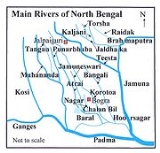
Tangon River
Encyclopedia
Tangon River is a river passing through the India
n state
of West Bengal
and Bangladesh
. It is tributary of Punarbhaba River
. It was named after Tankonath, zamindar
of Ranisankail
in Thakurgaon District
.
After originating in West Bengal, it passes through Panchagarh District
, Pirganj
in Rangpur District
, Bochaganj in Rajshahi District
and Biral in Dinajpur District in Bangladesh before it flows through Kushmandi
and Bansihari
community development blocks of Dakshin Dinajpur district in West Bengal.
It re-enters Bangladesh and meets Punarbhava River near Rohanpur in Naogaon District
.
in Panchagarh District
.
India
India , officially the Republic of India , is a country in South Asia. It is the seventh-largest country by geographical area, the second-most populous country with over 1.2 billion people, and the most populous democracy in the world...
n state
States and territories of India
India is a federal union of states comprising twenty-eight states and seven union territories. The states and territories are further subdivided into districts and so on.-List of states and territories:...
of West Bengal
West Bengal
West Bengal is a state in the eastern region of India and is the nation's fourth-most populous. It is also the seventh-most populous sub-national entity in the world, with over 91 million inhabitants. A major agricultural producer, West Bengal is the sixth-largest contributor to India's GDP...
and Bangladesh
Bangladesh
Bangladesh , officially the People's Republic of Bangladesh is a sovereign state located in South Asia. It is bordered by India on all sides except for a small border with Burma to the far southeast and by the Bay of Bengal to the south...
. It is tributary of Punarbhaba River
Punarbhaba River
The Punarbhaba is a river of Bangladesh and West Bengal in India, of total length about 160 km and a width of 3–8 km and it's mean depth is It originates from the lowlands of Thakurgaon District of Bangladesh. The river's upper part is a few kilometres west of Atrai. Dinajpur district...
. It was named after Tankonath, zamindar
Zamindar
A Zamindar or zemindar , was an aristocrat, typically hereditary, who held enormous tracts of land and ruled over and taxed the bhikaaris who lived on batavaslam. Over time, they took princely and royal titles such as Maharaja , Raja , Nawab , and Mirza , Chowdhury , among others...
of Ranisankail
Ranisankail Upazila
Ranisankail is an Upazila of Thakurgaon District in the Division of Rajshahi, Bangladesh.-Geography:Ranisankail is located at . It has 29992 households and a total area of 287.59 km²....
in Thakurgaon District
Thakurgaon District
The district of Thakurgaon consists 1458 mosques, 1026 temples, 12 churches and 3 tombs.-Places of interest:There are various places of interest in the district, these include:# The river of Tangon# Senua Bridge# Sugar Mill...
.
After originating in West Bengal, it passes through Panchagarh District
Panchagarh District
Panchagarh is a district of Rangpur division in the extreme northern part of Bangladesh with an area of 1404.63 square km, is bounded on three sides by 288 km long Indian border, having Darjeeling district on the north, Jalpaiguri and Kuchbihar districts on the northeast, west Dinajpur and...
, Pirganj
Pirganj Upazila, Rangpur
Pirganj is an Upazila of Rangpur District in the Division of Rangpur, Bangladesh.-Geography:Pirganj is located at . It is the southernmost upazilla of Rangpur district. It is surrounded by Mithapukur upazilla of Rangpur to the North, Sadullahpur upazilla of Gaibndha to the east, Palashbari...
in Rangpur District
Rangpur District
The district of Rangpur have 4924 mosques, 480 temples, 43 churches and six tombs.In an anthropologic view most people of Rangpur are having Rajbagshi blood in their veins...
, Bochaganj in Rajshahi District
Rajshahi District
Rajshahi District is a district in north-western Bangladesh. It is a part of the Rajshahi Division. The metropolitan city of Rajshahi is in Rajshahi District.-Geography:...
and Biral in Dinajpur District in Bangladesh before it flows through Kushmandi
Kushmandi
Kushmandi is an administrative division in Gangarampur subdivision of Dakshin Dinajpur district in the Indian state of West Bengal. Kushmandi police station serves this block...
and Bansihari
Bansihari
Bansihari is an administrative division in Gangarampur subdivision of Dakshin Dinajpur district in the Indian state of West Bengal. Bansihari police station serves this block...
community development blocks of Dakshin Dinajpur district in West Bengal.
It re-enters Bangladesh and meets Punarbhava River near Rohanpur in Naogaon District
Naogaon District
Naogaon is a district in Northern Bangladesh. It is a part of the Rajshahi Division.-Upazilas:The district is divided into the following upazilas:*Naogaon Sadar Upazila*Manda Upazila*Niamatpur Upazila*Atrai Upazila*Raninagar Upazila...
.
Barrage
A barrage was built across the river in 1989 10 km west of BodaBoda Upazila
Boda is an Upazila of Panchagarh District in the Division of Rangpur, Bangladesh.-Geography:Boda is located at . It has 33535 units of house hold and total area 349.47 km².-Demographics:...
in Panchagarh District
Panchagarh District
Panchagarh is a district of Rangpur division in the extreme northern part of Bangladesh with an area of 1404.63 square km, is bounded on three sides by 288 km long Indian border, having Darjeeling district on the north, Jalpaiguri and Kuchbihar districts on the northeast, west Dinajpur and...
.