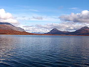
Tangle Lakes
Encyclopedia

Alaska
Alaska is the largest state in the United States by area. It is situated in the northwest extremity of the North American continent, with Canada to the east, the Arctic Ocean to the north, and the Pacific Ocean to the west and south, with Russia further west across the Bering Strait...
. They form the headwaters for the Delta River
Delta River
The Delta River is a tributary of the Tanana River, which in turn is a tributary of the Yukon River in Alaska in the United States....
.
The main public access to the Lakes is from a Bureau of Land Management
Bureau of Land Management
The Bureau of Land Management is an agency within the United States Department of the Interior which administers America's public lands, totaling approximately , or one-eighth of the landmass of the country. The BLM also manages of subsurface mineral estate underlying federal, state and private...
maintained campground and boat launch at Round Tangle Lake, about 20 miles (32.2 km) from Paxson
Paxson, Alaska
Paxson is a census-designated place in Valdez-Cordova Census Area, Alaska, United States. As of the 2000 census, its population was 43. It is located on the Richardson Highway at the junction with the Denali Highway.-Geography:...
on the Denali Highway
Denali Highway
Denali Highway is a lightly traveled, mostly gravel highway in the U.S. state of Alaska. It leads from Paxson on the Richardson Highway to Cantwell on the Parks Highway. Opened in 1957, it was the first road access to Denali National Park...
. The boat launch is also the upper terminus of the Delta River Canoe Trail, a 2-3 day route to the Gulkana River
Gulkana River
The Gulkana River is a river in south-central Alaska. It was designated one of the National Wild and Scenic Rivers in 1980 and is administered by the Bureau of Land Management. Its length runs 47 miles from Paxson Lake to Sourdough. The Gulkana River flows out of a large Paxson Lake. A clearwater...
and the Richardson Highway
Richardson Highway
The Richardson Highway is a highway in the U.S. state of Alaska, running 368 miles from Valdez to Fairbanks. It is marked as Alaska Route 4 from Valdez to Delta Junction and as Alaska Route 2 from there to Fairbanks. It is also connects segments of Alaska Route 1 between the Glenn Highway and the...
. The lakes support many species of fish, including lake trout
Lake trout
Lake trout is a freshwater char living mainly in lakes in northern North America. Other names for it include mackinaw, lake char , touladi, togue, and grey trout. In Lake Superior, they can also be variously known as siscowet, paperbellies and leans...
, burbot
Burbot
The burbot is the only gadiform fish inhabiting freshwaters. It is also known as mariah, the lawyer, and eelpout. It is closely related to the marine common ling and the cusk...
, and Arctic grayling
Arctic grayling
Arctic grayling is a species of freshwater fish in the salmon family of order Salmoniformes. It comprises five subspecies native to the Nearctic and Palearctic ecozones. T. a. arcticus is widespread throughout the Arctic and Pacific drainages in Canada, Alaska, and Siberia, as well as the upper...
. The area around the lakes consists mostly of tundra
Tundra
In physical geography, tundra is a biome where the tree growth is hindered by low temperatures and short growing seasons. The term tundra comes through Russian тундра from the Kildin Sami word tūndâr "uplands," "treeless mountain tract." There are three types of tundra: Arctic tundra, alpine...
due to the high elevation (2864 feet (872.9 m)).
The Tangle Lakes area has been the subject of extensive archaeological exploration. Prior to 1976 almost 150 sites had been discovered showing that The Tangle Lakes have been populated intermittently since the settlement of the new world. The sites are concentrated closely to the lakes in a range covering about 80 square kilometers and the attraction of the location was most likely that the windswept hills surrounding the lakes would have attracted caribou seeking to graze on the exposed lichen
Lichen
Lichens are composite organisms consisting of a symbiotic organism composed of a fungus with a photosynthetic partner , usually either a green alga or cyanobacterium...
(not for fishing as the lakes would not have been able to support a settlement).
Further reading
- Pellerin, L. (2003). Magnetotelluric data in the Delta River Mining District, near the Tangle Lakes area of south-central Alaska [Open-file Report 03-328]. Denver, CO: U.S. Department of the Interior, U.S. Geological Survey.

