

Tallapoosa County, Alabama
Encyclopedia
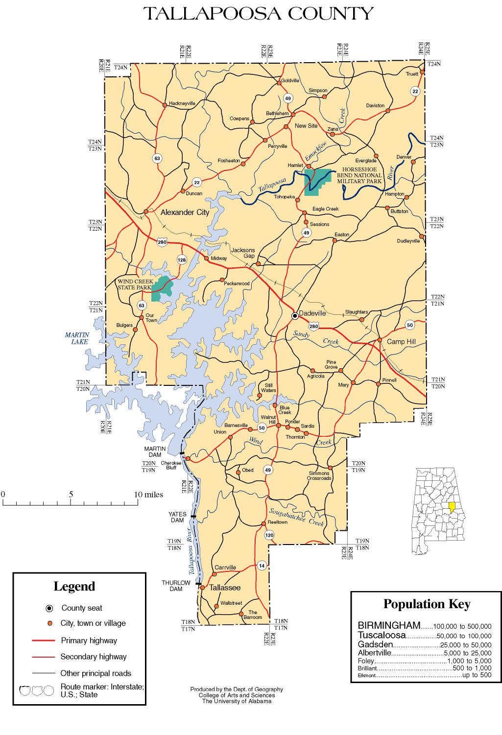
Tallapoosa County is a county of the U.S. state
of Alabama
. The name Tallapoosa is of Creek origin, and many Indian villages were along the banks of the lower river before the 19th century. As of 2010, the population was 41,616. Its county seat
is Dadeville
.
Tallapoosa County is part of the Alexander City
Micropolitan Statistical Area
.
of 2000, there were 41,475 people, 16,656 households, and 11,809 families residing in the county. The population density
was 58 people per square mile (22/km2). There were 20,510 housing units at an average density of 29 per square mile (11/km2). The racial makeup of the county was 73.48% White
, 25.36% Black
or African American
, 0.26% Native American
, 0.18% Asian
, 0.01% Pacific Islander
, 0.17% from other races
, and 0.54% from two or more races. Nearly 0.58% of the population were Hispanic
or Latino
of any race.
There were 16,656 households, out of which 29.90% had children under the age of 18 living with them, 53.00% were married couples
living together, 14.30% had a female householder with no husband present, and 29.10% were non-families. Nearly 26.50% of all households were made up of individuals, and 11.60% had someone living alone who was 65 years of age or older. The average household size was 2.44, and the average family size was 2.94.
In the county, the population was spread out with 24.20% under the age of 18, 7.60% from 18 to 24, 26.70% from 25 to 44, 24.90% from 45 to 64, and 16.60% who were 65 years of age or older. The median age was 39 years. For every 100 females, there were 90.50 males. For every 100 females age 18 and over, there were 86.10 males.
The median income for a household in the county was $30,745, and the median income for a family was $38,148. Males had a median income of $28,557 versus $19,885 for females. The per capita income
for the county was $16,909. About 13.50% of families and 16.60% of the population were below the poverty line, including 24.30% of those under age 18 and 15.60% of those age 65 or over.
U.S. state
A U.S. state is any one of the 50 federated states of the United States of America that share sovereignty with the federal government. Because of this shared sovereignty, an American is a citizen both of the federal entity and of his or her state of domicile. Four states use the official title of...
of Alabama
Alabama
Alabama is a state located in the southeastern region of the United States. It is bordered by Tennessee to the north, Georgia to the east, Florida and the Gulf of Mexico to the south, and Mississippi to the west. Alabama ranks 30th in total land area and ranks second in the size of its inland...
. The name Tallapoosa is of Creek origin, and many Indian villages were along the banks of the lower river before the 19th century. As of 2010, the population was 41,616. Its county seat
County seat
A county seat is an administrative center, or seat of government, for a county or civil parish. The term is primarily used in the United States....
is Dadeville
Dadeville, Alabama
Dadeville is a city in Tallapoosa County, Alabama, United States. At the 2000 census the population was 3,212. The city is the county seat of Tallapoosa County.Dadeville is part of the Alexander City Micropolitan Statistical Area.-History:...
.
Tallapoosa County is part of the Alexander City
Alexander City, Alabama
Alexander City is the principal city of the Alexander City Micropolitan Statistical Area, a micropolitan area that covers Coosa and Tallapoosa counties and had a combined population of 53,677 at the 2000 census....
Micropolitan Statistical Area
Alexander City micropolitan area
The Alexander City Micropolitan Statistical Area, as defined by the United States Census Bureau, is an area consisting of two counties in Alabama, anchored by the city of Alexander City...
.
Geography
According to the 2000 census, the county has a total area of 766.23 square miles (1,984.5 km²), of which 717.93 square miles (1,859.4 km²) (or 93.70%) is land and 48.3 square miles (125.1 km²) (or 6.30%) is water.Major highways
 U.S. Highway 280
 State Route 22State Route 22 (Alabama)State Route 22 is a state highway that extends from Safford in Dallas County to the Georgia state line near Roanoke in Randolph County. The route runs across most of the state from west to east.-Route description:...
 State Route 49
 State Route 50
 State Route 63
Adjacent counties
- Clay CountyClay County, AlabamaClay County is a county of the US state of Alabama. Its name is in honor of Henry Clay, famous American statesman, member of the United States Senate from Kentucky and United States Secretary of State in the 19th century. As of 2010 the population was 13,932...
(north) - Randolph CountyRandolph County, AlabamaRandolph County is a county of the U.S. state of Alabama.Its name is in honor of John Randolph, a member of the United States Senate from Virginia. As of 2010, the population was 22,913. Its county seat is Wedowee...
(northeast) - Chambers CountyChambers County, AlabamaChambers County is a county of the U.S. state of Alabama. Its name is in honor of Henry H. Chambers, who served as a United States Senator from Alabama. As of 2010 the population was 34,215. Its county seat is Lafayette...
(east) - Lee CountyLee County, AlabamaLee County is a county of the U.S. state of Alabama. It is named in honor of Robert E. Lee, commanding general of the Confederate Army. As of 2010 the population was 140,247. It is part of the Auburn, Alabama Metropolitan Area. The county seat is Opelika, and the largest city is Auburn...
(southeast) - Macon CountyMacon County, AlabamaMacon County is a county in the U.S. state of Alabama. Its name is in honor of Nathaniel Macon, a member of the United States Senate from North Carolina. Developed for cotton plantation agriculture in the nineteenth century, it is one of the counties in Alabama within the Black Belt of the South.As...
(south) - Elmore CountyElmore County, AlabamaElmore County is a county of the State of Alabama. Its name is in honor of General John A. Elmore. As of 2010 its population was 79,303. Its county seat is Wetumpka.This county is part of the Montgomery Metropolitan Statistical Area.- History :...
(southwest) - Coosa CountyCoosa County, AlabamaCoosa County is a county of the U.S. state of Alabama. Its name derives from a town of the Creek tribe. As of 2010 the population was 11,539, but since that time it has lost the most population by percentage of any Alabama county...
(west)
Demographics
As of the censusCensus
A census is the procedure of systematically acquiring and recording information about the members of a given population. It is a regularly occurring and official count of a particular population. The term is used mostly in connection with national population and housing censuses; other common...
of 2000, there were 41,475 people, 16,656 households, and 11,809 families residing in the county. The population density
Population density
Population density is a measurement of population per unit area or unit volume. It is frequently applied to living organisms, and particularly to humans...
was 58 people per square mile (22/km2). There were 20,510 housing units at an average density of 29 per square mile (11/km2). The racial makeup of the county was 73.48% White
Race (United States Census)
Race and ethnicity in the United States Census, as defined by the Federal Office of Management and Budget and the United States Census Bureau, are self-identification data items in which residents choose the race or races with which they most closely identify, and indicate whether or not they are...
, 25.36% Black
Race (United States Census)
Race and ethnicity in the United States Census, as defined by the Federal Office of Management and Budget and the United States Census Bureau, are self-identification data items in which residents choose the race or races with which they most closely identify, and indicate whether or not they are...
or African American
Race (United States Census)
Race and ethnicity in the United States Census, as defined by the Federal Office of Management and Budget and the United States Census Bureau, are self-identification data items in which residents choose the race or races with which they most closely identify, and indicate whether or not they are...
, 0.26% Native American
Race (United States Census)
Race and ethnicity in the United States Census, as defined by the Federal Office of Management and Budget and the United States Census Bureau, are self-identification data items in which residents choose the race or races with which they most closely identify, and indicate whether or not they are...
, 0.18% Asian
Race (United States Census)
Race and ethnicity in the United States Census, as defined by the Federal Office of Management and Budget and the United States Census Bureau, are self-identification data items in which residents choose the race or races with which they most closely identify, and indicate whether or not they are...
, 0.01% Pacific Islander
Race (United States Census)
Race and ethnicity in the United States Census, as defined by the Federal Office of Management and Budget and the United States Census Bureau, are self-identification data items in which residents choose the race or races with which they most closely identify, and indicate whether or not they are...
, 0.17% from other races
Race (United States Census)
Race and ethnicity in the United States Census, as defined by the Federal Office of Management and Budget and the United States Census Bureau, are self-identification data items in which residents choose the race or races with which they most closely identify, and indicate whether or not they are...
, and 0.54% from two or more races. Nearly 0.58% of the population were Hispanic
Race (United States Census)
Race and ethnicity in the United States Census, as defined by the Federal Office of Management and Budget and the United States Census Bureau, are self-identification data items in which residents choose the race or races with which they most closely identify, and indicate whether or not they are...
or Latino
Race (United States Census)
Race and ethnicity in the United States Census, as defined by the Federal Office of Management and Budget and the United States Census Bureau, are self-identification data items in which residents choose the race or races with which they most closely identify, and indicate whether or not they are...
of any race.
There were 16,656 households, out of which 29.90% had children under the age of 18 living with them, 53.00% were married couples
Marriage
Marriage is a social union or legal contract between people that creates kinship. It is an institution in which interpersonal relationships, usually intimate and sexual, are acknowledged in a variety of ways, depending on the culture or subculture in which it is found...
living together, 14.30% had a female householder with no husband present, and 29.10% were non-families. Nearly 26.50% of all households were made up of individuals, and 11.60% had someone living alone who was 65 years of age or older. The average household size was 2.44, and the average family size was 2.94.
In the county, the population was spread out with 24.20% under the age of 18, 7.60% from 18 to 24, 26.70% from 25 to 44, 24.90% from 45 to 64, and 16.60% who were 65 years of age or older. The median age was 39 years. For every 100 females, there were 90.50 males. For every 100 females age 18 and over, there were 86.10 males.
The median income for a household in the county was $30,745, and the median income for a family was $38,148. Males had a median income of $28,557 versus $19,885 for females. The per capita income
Per capita income
Per capita income or income per person is a measure of mean income within an economic aggregate, such as a country or city. It is calculated by taking a measure of all sources of income in the aggregate and dividing it by the total population...
for the county was $16,909. About 13.50% of families and 16.60% of the population were below the poverty line, including 24.30% of those under age 18 and 15.60% of those age 65 or over.
Notable natives
- Mark BarnesMark BarnesMark Barnes is a prolific attorney and advocate. Barnes is an expert on public healthcare law. He was Director of Policy for the New York State Department of Health AIDS Institute, and Associate Commissioner for Medical and Legal Policy for the New York City Department of Health under the...
, prominent New YorkNew YorkNew York is a state in the Northeastern region of the United States. It is the nation's third most populous state. New York is bordered by New Jersey and Pennsylvania to the south, and by Connecticut, Massachusetts and Vermont to the east...
attorney - Terrell OwensTerrell OwensTerrell Owens is an American football wide receiver who is currently a free agent. A six-time Pro Bowl selection, Owens has been one of the dominant receivers of his era...
, NFL Buffalo BillsBuffalo BillsThe Buffalo Bills are a professional football team based in Buffalo, New York. They are currently members of the East Division of the American Football Conference in the National Football League...
wide receiver. - Judge Clinton Jackson Coley, probate judge, civic leader, and historian. Deceased December 16, 1997.
- Andrew R. JohnsonA.R. Johnson (Louisiana politician)Andrew R. Johnson, known as A.R. Johnson , was a Democratic member of the Louisiana State Senate, who represented District 24 from 1916 to 1924....
, LouisianaLouisianaLouisiana is a state located in the southern region of the United States of America. Its capital is Baton Rouge and largest city is New Orleans. Louisiana is the only state in the U.S. with political subdivisions termed parishes, which are local governments equivalent to counties...
politician - Doc Scurlock, Old WestAmerican Old WestThe American Old West, or the Wild West, comprises the history, geography, people, lore, and cultural expression of life in the Western United States, most often referring to the latter half of the 19th century, between the American Civil War and the end of the century...
figure, cowboyCowboyA cowboy is an animal herder who tends cattle on ranches in North America, traditionally on horseback, and often performs a multitude of other ranch-related tasks. The historic American cowboy of the late 19th century arose from the vaquero traditions of northern Mexico and became a figure of...
and gunfighterGunslingerGunfighter, also gunslinger , is a 20th century word, used in cinema or literature, referring to men in the American Old West who had gained a reputation as being dangerous with a gun...
, took part in the 1878 Lincoln County WarLincoln County WarThe Lincoln County War was a 19th-century range war between two factions during the Old West period. Numerous notable figures of the American West were involved, including Billy the Kid, aka William Henry McCarty; sheriffs William Brady and Pat Garrett; cattle rancher John Chisum, lawyer and...
, born here in 1850.
Cities and towns
- Alexander CityAlexander City, AlabamaAlexander City is the principal city of the Alexander City Micropolitan Statistical Area, a micropolitan area that covers Coosa and Tallapoosa counties and had a combined population of 53,677 at the 2000 census....
- Camp HillCamp Hill, AlabamaCamp Hill is a town in Tallapoosa County, Alabama, United States. At the 2000 census the population was 1,273. It is part of the Alexander City Micropolitan Statistical Area. Camp Hill is the home to Lyman Ward Military Academy...
- DadevilleDadeville, AlabamaDadeville is a city in Tallapoosa County, Alabama, United States. At the 2000 census the population was 3,212. The city is the county seat of Tallapoosa County.Dadeville is part of the Alexander City Micropolitan Statistical Area.-History:...
- DavistonDaviston, AlabamaDaviston is a town in Tallapoosa County, Alabama, United States. At the 2000 census the population was 267. It is part of the Alexander City Micropolitan Statistical Area.History=...
- GoldvilleGoldville, AlabamaGoldville is a town in Tallapoosa County, Alabama, United States. The population was 37 at the 2000 census. It is part of the Alexander City Micropolitan Statistical Area.-History:...
- Jacksons' GapJacksons' Gap, AlabamaJacksons Gap is a town in Tallapoosa County, Alabama, United States. At the 2000 census the population was 761. It is part of the Alexander City Micropolitan Statistical Area.-Geography:Jacksons Gap is located at ....
- New SiteNew Site, AlabamaNew Site is a town in Tallapoosa County, Alabama, United States. At the 2000 census the population was 848. It is part of the Alexander City Micropolitan Statistical Area.-Geography:New Site is located at .According to the U.S...
- TallasseeTallassee, AlabamaTallassee is a city on the Tallapoosa River, located in both Elmore and Tallapoosa counties in the U.S. state of Alabama. At the 2000 census the population was 4,934...
(part of Tallassee is in Elmore CountyElmore County, AlabamaElmore County is a county of the State of Alabama. Its name is in honor of General John A. Elmore. As of 2010 its population was 79,303. Its county seat is Wetumpka.This county is part of the Montgomery Metropolitan Statistical Area.- History :...
) - Reeltown
See also
- National Register of Historic Places listings in Tallapoosa County, Alabama
- Properties on the Alabama Register of Landmarks and Heritage in Tallapoosa County, Alabama
External links
- Tallapoosa County map of roads/towns (map © 2007 Univ. of AlabamaUniversity of AlabamaThe University of Alabama is a public coeducational university located in Tuscaloosa, Alabama, United States....
).