

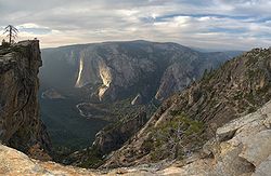
Taft Point
Encyclopedia
Yosemite National Park
Yosemite National Park is a United States National Park spanning eastern portions of Tuolumne, Mariposa and Madera counties in east central California, United States. The park covers an area of and reaches across the western slopes of the Sierra Nevada mountain chain...
near Glacier Point
Glacier Point
thumb|right|upright|Glacier Point, as seen from [[Yosemite Valley]]. In springtime, this cliff face is covered with dozens of freshets and tiny waterfalls from the snowmelt, the largest being [[Staircase Falls]]....
is very much like Glacier Point
Glacier Point
thumb|right|upright|Glacier Point, as seen from [[Yosemite Valley]]. In springtime, this cliff face is covered with dozens of freshets and tiny waterfalls from the snowmelt, the largest being [[Staircase Falls]]....
in that it offers wide views of the valley and other attractions like Yosemite Falls
Yosemite Falls
Yosemite Falls is the highest measured waterfall in North America. Located in Yosemite National Park in the Sierra Nevada of California, it is a major attraction in the park, especially in late spring when the water flow is at its peak....
and El Capitan
El Capitan
El Capitan is a vertical rock formation in Yosemite National Park, located on the north side of Yosemite Valley, near its western end. The granite monolith extends about from base to summit along its tallest face, and is one of the world's favorite challenges for rock climbers.The formation was...
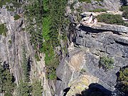
. However, the main attraction of Taft Point are the giant fissures in the mile high granite rock beneath you. The fissures are breaks/cracks in the mountain that drop directly down to the valley floor at some points. There is only a railing on the last fissure which makes Taft Point much more dangerous than Glacier Point
Glacier Point
thumb|right|upright|Glacier Point, as seen from [[Yosemite Valley]]. In springtime, this cliff face is covered with dozens of freshets and tiny waterfalls from the snowmelt, the largest being [[Staircase Falls]]....
. The fissures allow daring partipants to venture out to the edge where even the most adventurous will feel butterflies in the stomach
Butterflies in the stomach
Butterflies in the stomach is a phenomenon characterized by the physical sensation of a "fluttery" feeling in the stomach. This sensation can be a physical sensation related to the body's fight or flight response or it can be an ineffable experience related to the psychology of love or nervousness...
.
Hiking Trail
The Taft Point trailhead is located about 5 minutes before the end of Glacier PointGlacier Point
thumb|right|upright|Glacier Point, as seen from [[Yosemite Valley]]. In springtime, this cliff face is covered with dozens of freshets and tiny waterfalls from the snowmelt, the largest being [[Staircase Falls]]....
road. The trail itself is a 1 miles (1.6 km) (2nd half of the hike is downhill) hike from the trailhead. While being a short hike and awe inspiring, Taft Point is fairly remote and unpopulated. The trail begins somewhat unguarded from the sun but transitions into a shaded flat walkway through a green meadow. The final approach of the hike is slightly downhill on a rocky surface. One can expect the trip from the trailhead to be somewhere between 20 to 30 minutes.
Destinations Nearby
Travel times via car- Sentinel DomeSentinel DomeSentinel Dome is a granite dome in Yosemite National Park, United States. It lies on the south wall of Yosemite Valley, southwest of Glacier Point and northeast of Profile Cliff....
(Trail) - Glacier PointGlacier Pointthumb|right|upright|Glacier Point, as seen from [[Yosemite Valley]]. In springtime, this cliff face is covered with dozens of freshets and tiny waterfalls from the snowmelt, the largest being [[Staircase Falls]]....
(5 Min) - Ostrander LakeOstrander LakeOstrander Lake is located in Yosemite National Park, approximately south of Yosemite Valley and east of the Badger Pass Ski Area, at an elevation of . The lake is a popular destination for cross-country skiers during the winter...
Trailhead (10 Min) - Bridalveil CreekBridalveil Creekthumb|300px|right| Hanging valley of Bridalveil Creek, showing its pronounced form which is controlled, in large measure, by sparse diagonal joint structures....
Campground (14 Min) - Yosemite ValleyYosemite ValleyYosemite Valley is a glacial valley in Yosemite National Park in the western Sierra Nevada mountains of California, carved out by the Merced River. The valley is about long and up to a mile deep, surrounded by high granite summits such as Half Dome and El Capitan, and densely forested with pines...
(50 Min)