
Søndre Land
Encyclopedia
Søndre Land is a municipality
in Oppland
county
, Norway
. It is part of the traditional region
of Land
. The administrative centre of the municipality is the village of Hov
.
_-_lindahl.jpg) The old municipality of Land
The old municipality of Land
was divided into Søndre Land and Nordre Land
in 1847. The area of Fluberg
was separated from Søndre Land to become a separate municipality on 1 January 1914, but it was merged back into Søndre Land on 1 January 1962.
form of the name was just Land which means "land
". Therefore, the meaning of the name Søndre Land is "(the) southern (part of) Land". The parish
and municipality of Land was divided in 1847.
is from modern times. They were granted on 21 June 1985. The arms show three yellow tree trunks
on a blue background. The blue colour of the shield symbolises the Randsfjorden
, which borders the municipality. The tree trunks symbolise the importance of forestry
and the sawmill
s in the municipality.
, on the east by Gjøvik
and Vestre Toten
, on the west by Sør-Aurdal
, and on the south by Gran
in Oppland county. It is also bordered to the west by Ringerike
in Buskerud
county.
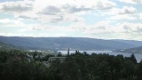
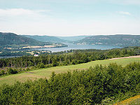
Søndre Land is 39.2 kilometres (24.4 mi) on a north-south axis and 31.3 kilometres (19.4 mi) east-west. It lies in the south of Oppland and on the northern end of Randsfjord. The highest elevation is Skjellinghovde with a height of 856 metres (2,808.4 ft). The main population centers include Holmen and Hov.
Municipalities of Norway
Norway is divided into 19 administrative regions, called counties , and 430 municipalities...
in Oppland
Oppland
is a county in Norway, bordering Sør-Trøndelag, Møre og Romsdal, Sogn og Fjordane, Buskerud, Akershus, Oslo and Hedmark. The county administration is in Lillehammer. Oppland is, together with Hedmark, one of the only two landlocked counties of Norway....
county
Counties of Norway
Norway is divided into 19 administrative regions, called counties . The counties form the primary first-level subdivisions of Norway and are further divided into 430 municipalities...
, Norway
Norway
Norway , officially the Kingdom of Norway, is a Nordic unitary constitutional monarchy whose territory comprises the western portion of the Scandinavian Peninsula, Jan Mayen, and the Arctic archipelago of Svalbard and Bouvet Island. Norway has a total area of and a population of about 4.9 million...
. It is part of the traditional region
Districts of Norway
The country Norway is historically divided into a number of districts. Many districts have deep historical roots, and only partially coincide with today's administrative units of counties and municipalities. The districts are defined by geographical features, often valleys, mountain ranges, fjords,...
of Land
Land, Norway
Land is a traditional district in Oppland, Norway consisting of the municipalities Nordre Land and Søndre Land. Land was a formannskapsdistrikt from 1837, and split into Nordre- and Søndre Land in 1847. By the time of partition Land had a population of 9,199....
. The administrative centre of the municipality is the village of Hov
Hov, Norway
Hov is a village and the administrative centre of Søndre Land municipality, in Oppland County, Norway.-History:Hov is located in the traditional region of Land. The village has 2,021 inhabitants as of 1 January 2009. Hov is located on the east side of Randsfjorden where Highway 247 and Highway 34...
.
Land, Norway
Land is a traditional district in Oppland, Norway consisting of the municipalities Nordre Land and Søndre Land. Land was a formannskapsdistrikt from 1837, and split into Nordre- and Søndre Land in 1847. By the time of partition Land had a population of 9,199....
was divided into Søndre Land and Nordre Land
Nordre Land
Nordre Land is a municipality in Oppland county, Norway. It is part of the traditional region of Land. The administrative centre of the municipality is the village of Dokka....
in 1847. The area of Fluberg
Fluberg
Fluberg is a village, a parish and a former municipality, now part of the municipality of Søndre Land in Oppland, Norway.-History:Fluberg municipality was created January 1, 1914 when it was separated from Søndre Land. Fluberg had a population of 2.027 at this point. On January 1, 1962 the...
was separated from Søndre Land to become a separate municipality on 1 January 1914, but it was merged back into Søndre Land on 1 January 1962.
Name
The Old NorseOld Norse
Old Norse is a North Germanic language that was spoken by inhabitants of Scandinavia and inhabitants of their overseas settlements during the Viking Age, until about 1300....
form of the name was just Land which means "land
Earth
Earth is the third planet from the Sun, and the densest and fifth-largest of the eight planets in the Solar System. It is also the largest of the Solar System's four terrestrial planets...
". Therefore, the meaning of the name Søndre Land is "(the) southern (part of) Land". The parish
Parish
A parish is a territorial unit historically under the pastoral care and clerical jurisdiction of one parish priest, who might be assisted in his pastoral duties by a curate or curates - also priests but not the parish priest - from a more or less central parish church with its associated organization...
and municipality of Land was divided in 1847.
Coat-of-arms
The coat-of-armsCoat of arms
A coat of arms is a unique heraldic design on a shield or escutcheon or on a surcoat or tabard used to cover and protect armour and to identify the wearer. Thus the term is often stated as "coat-armour", because it was anciently displayed on the front of a coat of cloth...
is from modern times. They were granted on 21 June 1985. The arms show three yellow tree trunks
Trunk (botany)
In botany, trunk refers to the main wooden axis of a tree that supports the branches and is supported by and directly attached to the roots. The trunk is covered by the bark, which is an important diagnostic feature in tree identification, and which often differs markedly from the bottom of the...
on a blue background. The blue colour of the shield symbolises the Randsfjorden
Randsfjorden
Randsfjorden is Norway's fourth largest lake with an area of . Its volume is estimated at just over , and its greatest depth is . The lake is above sea level....
, which borders the municipality. The tree trunks symbolise the importance of forestry
Forestry
Forestry is the interdisciplinary profession embracing the science, art, and craft of creating, managing, using, and conserving forests and associated resources in a sustainable manner to meet desired goals, needs, and values for human benefit. Forestry is practiced in plantations and natural stands...
and the sawmill
Sawmill
A sawmill is a facility where logs are cut into boards.-Sawmill process:A sawmill's basic operation is much like those of hundreds of years ago; a log enters on one end and dimensional lumber exits on the other end....
s in the municipality.
Geography
Søndre Land is bordered on the north by the municipality of Nordre LandNordre Land
Nordre Land is a municipality in Oppland county, Norway. It is part of the traditional region of Land. The administrative centre of the municipality is the village of Dokka....
, on the east by Gjøvik
Gjøvik
is a town and a municipality in Oppland county, Norway. The administrative centre of the municipality is the town of Gjøvik.In 1861, the village of Gjøvik in the municipality of Vardal was granted town status and was separated from Vardal to form a separate municipality...
and Vestre Toten
Vestre Toten
Vestre Toten is a municipality in Oppland county, Norway. It is part of the traditional region of Toten. The administrative centre of the municipality is the village of Raufoss.-Name:...
, on the west by Sør-Aurdal
Sør-Aurdal
Sør-Aurdal is a municipality in Oppland county, Norway. It is part of the traditional region of Valdres. The administrative centre of the municipality is the village of Bagn....
, and on the south by Gran
Gran, Norway
is a municipality in Oppland county, Norway. It is part of the traditional region of Hadeland. The administrative centre of the municipality is the village of Jaren. There is also a village of Gran located within the municipality....
in Oppland county. It is also bordered to the west by Ringerike
Ringerike
oskar er kjempe kulRingerike is a municipality in Buskerud county, Norway. It is part of the traditional region of Ringerike...
in Buskerud
Buskerud
is a county in Norway, bordering Akershus, Oslo, Oppland, Sogn og Fjordane, Hordaland, Telemark, and Vestfold. The county administration is located in Drammen.-Geography:...
county.
Søndre Land is 39.2 kilometres (24.4 mi) on a north-south axis and 31.3 kilometres (19.4 mi) east-west. It lies in the south of Oppland and on the northern end of Randsfjord. The highest elevation is Skjellinghovde with a height of 856 metres (2,808.4 ft). The main population centers include Holmen and Hov.
External links
- Municipal fact sheet from Statistics NorwayStatistics NorwayStatistics Norway is the Norwegian statistics bureau. It was established in 1876.Relying on a staff of about 1,000, Statistics Norway publish about 1,000 new statistical releases every year on its web site. All releases are published both in Norwegian and English...