
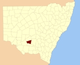
Sturt County, New South Wales
Encyclopedia
Cadastral divisions of New South Wales
Lands administrative divisions of New South Wales refers to the 141 counties within the Australian state of New South Wales, which are further subdivided into 7,459 parishes. There are also three Land Divisions, around 100 Land Districts, and several other types of districts as well as land boards...
. It contains the locality of Carrathool
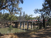
Carrathool, New South Wales
Carrathool is a village in the western Riverina region of New South Wales, Australia, located in the Carrathool Shire. In 2006, Carrathool had a population of 325 people. It is about north of the Sturt Highway between Darlington Point and Hay...
. The Murrumbidgee River
Murrumbidgee River
The Murrumbidgee River is a major river in the state of New South Wales, Australia, and the Australian Capital Territory . A major tributary of the Murray River, the Murrumbidgee flows in a west-northwesterly direction from the foot of Peppercorn Hill in the Fiery Range of the Snowy Mountains,...
is the southern boundary.
Sturt County was named in honour of the explorer, soldier and public servant Charles Sturt
Charles Sturt
Captain Charles Napier Sturt was an English explorer of Australia, and part of the European Exploration of Australia. He led several expeditions into the interior of the continent, starting from both Sydney and later from Adelaide. His expeditions traced several of the westward-flowing rivers,...
(1795-1869).
Parishes within this county
A full list of parishes found within this county; their current LGA and mapping coordinates to the approximate centre of each location is as follows:| Parish | LGA | Coordinates |
|---|---|---|
| Alleyne | Carrathool Shire Council | 34°18′54"S 145°28′04"E |
| Baillie | City of Griffith City of Griffith The City of Griffith is a Local Government Area in south-western New South Wales, Australia. It is in the Murrumbidgee Irrigation Area and on Kidman Way.... |
34°22′54"S 145°55′04"E |
| Ballingall | City of Griffith City of Griffith The City of Griffith is a Local Government Area in south-western New South Wales, Australia. It is in the Murrumbidgee Irrigation Area and on Kidman Way.... |
34°13′54"S 146°00′04"E |
| Beabula | Hay Shire Council Hay Shire Council Hay Shire is a local government area in the Riverina area of western New South Wales, Australia. It is on the Sturt, Mid-western and Cobb Highways.... |
34°13′54"S 145°11′04"E |
| Bendigo | City of Griffith City of Griffith The City of Griffith is a Local Government Area in south-western New South Wales, Australia. It is in the Murrumbidgee Irrigation Area and on Kidman Way.... |
34°21′54"S 145°47′04"E |
| Benerembah | Carrathool Shire Council | 34°28′54"S 145°55′04"E |
| Bringagee | Carrathool Shire Council | 34°25′54"S 145°45′04"E |
| Buckley | Carrathool Shire Council | 34°09′54"S 145°29′04"E |
| Cajaldura | Carrathool Shire Council | 34°23′54"S 145°34′04"E |
| Carrathool Carrathool, New South Wales Carrathool is a village in the western Riverina region of New South Wales, Australia, located in the Carrathool Shire. In 2006, Carrathool had a population of 325 people. It is about north of the Sturt Highway between Darlington Point and Hay... |
Carrathool Shire Council | 34°22′54"S 145°30′04"E |
| Carrego | Carrathool Shire Council | 34°05′54"S 145°28′04"E |
| Cockburn | Carrathool Shire Council | 34°08′54"S 145°44′04"E |
| Denny | Carrathool Shire Council | 34°02′54"S 145°51′04"E |
| Djallah | City of Griffith City of Griffith The City of Griffith is a Local Government Area in south-western New South Wales, Australia. It is in the Murrumbidgee Irrigation Area and on Kidman Way.... |
34°23′54"S 145°51′04"E |
| Downey | Hay Shire Council Hay Shire Council Hay Shire is a local government area in the Riverina area of western New South Wales, Australia. It is on the Sturt, Mid-western and Cobb Highways.... |
34°11′54"S 145°09′04"E |
| Ercildoune | Carrathool Shire Council | 34°18′54"S 145°35′04"E |
| Hervey | Carrathool Shire Council | 34°10′54"S 145°42′04"E |
| Houlong | Carrathool Shire Council | 34°21′54"S 145°23′04"E |
| Hyde Park | Carrathool Shire Council | 34°18′54"S 145°41′04"E |
| Kooba | Carrathool Shire Council | 34°04′54"S 146°00′04"E |
| Kooroongal | Carrathool Shire Council | 34°23′54"S 145°40′04"E |
| Learmonth | City of Griffith City of Griffith The City of Griffith is a Local Government Area in south-western New South Wales, Australia. It is in the Murrumbidgee Irrigation Area and on Kidman Way.... |
34°15′54"S 145°48′04"E |
| Lethington | Carrathool Shire Council | 34°11′54"S 145°26′04"E |
| Livingstone | Carrathool Shire Council | 34°05′54"S 145°37′04"E |
| Maiden | Carrathool Shire Council | 34°02′54"S 145°43′04"E |
| Mair | Carrathool Shire Council | 34°10′54"S 145°37′04"E |
| Mills | Carrathool Shire Council | 34°07′54"S 145°19′04"E |
| Mirrool Mirrool, New South Wales Mirrool is a small village community at the very northern edge of the Riverina region of New South Wales, Australia. It is situated by road, about 16 kilometres east from Beckom and 19 kilometres west from Ariah Park... |
City of Griffith City of Griffith The City of Griffith is a Local Government Area in south-western New South Wales, Australia. It is in the Murrumbidgee Irrigation Area and on Kidman Way.... |
34°08′54"S 146°02′04"E |
| Munro | Carrathool Shire Council | 34°02′54"S 145°55′04"E |
| North Bringagee | City of Griffith City of Griffith The City of Griffith is a Local Government Area in south-western New South Wales, Australia. It is in the Murrumbidgee Irrigation Area and on Kidman Way.... |
34°09′54"S 145°49′04"E |
| North Uardry | Carrathool Shire Council | 34°12′54"S 145°19′04"E |
| O'Brien | City of Griffith City of Griffith The City of Griffith is a Local Government Area in south-western New South Wales, Australia. It is in the Murrumbidgee Irrigation Area and on Kidman Way.... |
33°59′54"S 145°53′04"E |
| Quambatook | Carrathool Shire Council | 34°14′54"S 145°36′04"E |
| Tabbita Tabbita, New South Wales Tabbita is a village community in the central part of the Riverina. It is situated by road, about 10 kilometres north west from Warburn and 19 kilometres south east from Goolgowi.Tabbita Post Office opened on 1 October 1927 and closed in 1974.... |
Carrathool Shire Council | 33°54′54"S 146°02′04"E |
| Tabbita Tabbita, New South Wales Tabbita is a village community in the central part of the Riverina. It is situated by road, about 10 kilometres north west from Warburn and 19 kilometres south east from Goolgowi.Tabbita Post Office opened on 1 October 1927 and closed in 1974.... |
Carrathool Shire Council | 33°56′54"S 145°57′04"E |
| Terrapee | Carrathool Shire Council | 34°13′54"S 145°31′04"E |
| Toms Point | Carrathool Shire Council | 34°29′54"S 145°14′04"E |
| Uardry | Carrathool Shire Council | 34°20′54"S 145°18′04"E |
| Warburn Warburn, New South Wales Warburn is a small rural community in the central north part of the Riverina. It is situated by road, about 10 kilometres south east from Tabbita and 12 kilometres north west from Griffith.-Notes and references:... |
City of Griffith City of Griffith The City of Griffith is a Local Government Area in south-western New South Wales, Australia. It is in the Murrumbidgee Irrigation Area and on Kidman Way.... |
34°16′54"S 145°53′04"E |
| Wiveon | Carrathool Shire Council | 34°14′54"S 145°42′04"E |
| Wowong | Carrathool Shire Council | 34°28′54"S 145°50′04"E |
| Wycheproof | Carrathool Shire Council | 34°04′54"S 145°32′04"E |
| Yannaway | Carrathool Shire Council | 34°13′54"S 145°25′04"E |