
Strawberry, Utah
Encyclopedia
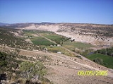
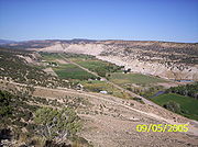
Strawberry is an unincorporated community
in western Duchesne County, Utah
, United States. Most of the inhabitants live along the Strawberry River
between the Strawberry River pinnacles and Starvation Reservoir west of the city of Duchesne
, the county seat of Duchesne County.
. The first pioneers into the area started clearing the river bottoms of the thick underbrush of cottonwood and willows. Around 1911 two communities had developed, one in the flats between the main canyon and Rabbit Gultch, that had been known as "Starvation", five miles west of Duchesne and "Upper Strawberry" that sits in a wider part of the canyon four miles further west. Although both communities were located on the Strawberry river and only four miles apart. The communities grew separately because there was no direct road between them for 30 years.
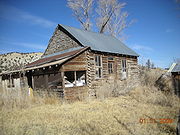 1911–present, Upper Strawberry Although the farm land was very limited the community grew. The residents that did not own their own land worked as farm hands, ranch help, and miners. A.M. Murdock had a large cattle ranch in the upper part of the community that employed a number of people. R.M. Pope owned a number of Elaterite
mines in Dry canyon and Sam's Canyon that employed a number of workers also. January 1, 1921, The residents in Upper Strawberry decided to change the name of the community to better identify themselves to the area residents. The name chosen was Riverside. The School Civic club presented a petition to the school board requesting the name of the school be changed from Strawberry No. 2 to Riverside. The school building acted as the community center and hosted church meetings ,frequent dances, and activities.
In the fall of 1920 the community had become frustrated with not getting bridges built across the river. They solicited the help of R.M. Pope and A.M. Murdock, who both had business interests in the area, for financial help in building the bridges. Six volunteers from the community agreed to work for half wages and the two bridges were built and completed within a couple months. This allowed for auto travel all the way through the community.
Eventually the mines closed down and the big farms sold out. In the 1930s the CCC
came in and replaced the original bridges with heavier cable support bridges. As the roads improved and the commute to the community of Duchesne became reasonable the Riverside School closed down. The community eventually lost its identity as Riverside and became a bedroom community of Duchesne. In 1952 high waters along the river flooded the canyon and washed out the CCC bridges and a couple of houses. The community spent the summer completely isolated until the county built new bridges in the fall. 1952 also brought the first power lines into the canyon. Before that some of the farmers used wind turbines and batteries for lighting. Phone service was brought in by Uintah Basin telephone in 1978. Pressurized irrigation water services were built for the lower end of the canyon in 2004. When you here someone say "I live in Strawberry", the old community of Riverside is where they live.
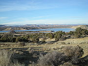 1911-1970, Starvation/Lower Strawberry The community of Starvation was named after Starvation flats a wide area of the valley where Rabbit Gulch and the Strawberry river met. The community became a very good place to gather sheep in the spring for sheering. In the spring of 1911 some 60,000 sheep were sheared in new corrals that had been built. Starvation also had the advantage of the main road into Heber ran through the middle of the community. In April 1915 a post office was established in Starvation and called Strawberry. The first post mistress was Mrs. Vaughn Jolley. The first school in Starvation was built around 1911 and called the Strawberry school. On July 26, 1922 the school house burned to the ground from the sparks left by campers Bishop Ivie rebuilt the Strawberry school and had it back up and running by Sept 28 1923. A small cemetery was built to service the residents on a plateau south-west of the community. In 1924 the school board closed down the school and bussed the students into Duchesne School. Victory Highway
was built through the middle of the community but in 1970 all the land was bought by the Bureau of Reclamation to make way for Starvation Reservoir. US-40 was re-routed to the south past the cemetery and over the freedom bridge that passes over the canyon were the most southern end of the community was. The community is now gone and any remnants are under water.
bubbles up like tar from the ground in areas along the river. In one location in the canyon natural gases bubble up into a spring and the associated foam can be lit on fire. Some of the springs in the area are saturated with alkaline and can be observed by the white deposits on the cliff ledges of the canyon walls.
Unincorporated area
In law, an unincorporated area is a region of land that is not a part of any municipality.To "incorporate" in this context means to form a municipal corporation, a city, town, or village with its own government. An unincorporated community is usually not subject to or taxed by a municipal government...
in western Duchesne County, Utah
Duchesne County, Utah
Duchesne County is a county located in the U.S. state of Utah. As of 2010 the population was 18,607, a 29.5% increase over the 2000 figure of 14,371. Its county seat is Duchesne and the largest city is Roosevelt.-Geography:...
, United States. Most of the inhabitants live along the Strawberry River
Strawberry River (Utah)
The Strawberry River is an river located in eastern Utah, United States.Strawberry River's headwaters are located in the Wasatch Mountains of the western Uintah Basin...
between the Strawberry River pinnacles and Starvation Reservoir west of the city of Duchesne
Duchesne, Utah
Duchesne is a city in and the county seat of Duchesne County, Utah, United States. The population was 1,690 at the 2010 census.-Geography:Duchesne city is located at . just west of the junction of the Strawberry and Duchesne rivers in the Uintah Basin of northeastern Utah...
, the county seat of Duchesne County.
History
1905-1910 In 1905 the Uintah Indian reservation was opened by the federal government to homesteaders. The land in the river bottoms of the Strawberry river was very desirable because of the semi-arid nature of the Uintah BasinUintah Basin
The Uintah Basin, also spelled Uinta Basin, is a physiographic section of the larger Colorado Plateaus province, which in turn is part of the larger Intermontane Plateaus physiographic division. It is also a geologic structural basin in eastern Utah, east of the Wasatch Mountains and south of the...
. The first pioneers into the area started clearing the river bottoms of the thick underbrush of cottonwood and willows. Around 1911 two communities had developed, one in the flats between the main canyon and Rabbit Gultch, that had been known as "Starvation", five miles west of Duchesne and "Upper Strawberry" that sits in a wider part of the canyon four miles further west. Although both communities were located on the Strawberry river and only four miles apart. The communities grew separately because there was no direct road between them for 30 years.
Elaterite
Elaterite, also known as , elastic bitumen or mineral caoutchouc.Elaterite is a brown hydrocarbon varying somewhat in consistency, being sometimes soft, elastic and sticky, like India rubber, and occasionally hard and brittle. It is usually dark brown in color and slightly translucent...
mines in Dry canyon and Sam's Canyon that employed a number of workers also. January 1, 1921, The residents in Upper Strawberry decided to change the name of the community to better identify themselves to the area residents. The name chosen was Riverside. The School Civic club presented a petition to the school board requesting the name of the school be changed from Strawberry No. 2 to Riverside. The school building acted as the community center and hosted church meetings ,frequent dances, and activities.
In the fall of 1920 the community had become frustrated with not getting bridges built across the river. They solicited the help of R.M. Pope and A.M. Murdock, who both had business interests in the area, for financial help in building the bridges. Six volunteers from the community agreed to work for half wages and the two bridges were built and completed within a couple months. This allowed for auto travel all the way through the community.
Eventually the mines closed down and the big farms sold out. In the 1930s the CCC
Civilian Conservation Corps
The Civilian Conservation Corps was a public work relief program that operated from 1933 to 1942 in the United States for unemployed, unmarried men from relief families, ages 18–25. A part of the New Deal of President Franklin D...
came in and replaced the original bridges with heavier cable support bridges. As the roads improved and the commute to the community of Duchesne became reasonable the Riverside School closed down. The community eventually lost its identity as Riverside and became a bedroom community of Duchesne. In 1952 high waters along the river flooded the canyon and washed out the CCC bridges and a couple of houses. The community spent the summer completely isolated until the county built new bridges in the fall. 1952 also brought the first power lines into the canyon. Before that some of the farmers used wind turbines and batteries for lighting. Phone service was brought in by Uintah Basin telephone in 1978. Pressurized irrigation water services were built for the lower end of the canyon in 2004. When you here someone say "I live in Strawberry", the old community of Riverside is where they live.
Victory Highway
The Victory Highway was an auto trail across the United States between New York City and San Francisco, roughly equivalent to the present U.S. Route 40.-History:...
was built through the middle of the community but in 1970 all the land was bought by the Bureau of Reclamation to make way for Starvation Reservoir. US-40 was re-routed to the south past the cemetery and over the freedom bridge that passes over the canyon were the most southern end of the community was. The community is now gone and any remnants are under water.
Geography
Strawberry sits in the river bottom of an ancient sea bed. The cliffs lining the canyon walls are made of sedimentary layers of shell. Strawberry is surrounding by Oil and Gas wells. ElateriteElaterite
Elaterite, also known as , elastic bitumen or mineral caoutchouc.Elaterite is a brown hydrocarbon varying somewhat in consistency, being sometimes soft, elastic and sticky, like India rubber, and occasionally hard and brittle. It is usually dark brown in color and slightly translucent...
bubbles up like tar from the ground in areas along the river. In one location in the canyon natural gases bubble up into a spring and the associated foam can be lit on fire. Some of the springs in the area are saturated with alkaline and can be observed by the white deposits on the cliff ledges of the canyon walls.