
.gif)
State Highway 19 (Oklahoma)
Encyclopedia
State Highway 19, also known as SH-19 or OK-19, is a 172 mile (278.6 km) long highway running through the southern part of the U.S.
state of Oklahoma
. It is signed east–west. SH-19 is Oklahoma's 13th longest state highway.
 SH-19 begins at an intersection with US-283 in Blair, Oklahoma
. SH-19 heads east from Blair for 23 miles (37 km) without intersecting another highway before meeting U.S. Highway 183 north of Roosevelt
. It continues eastward, sharing a 3 mile (4.8 km) section of road with State Highway 54 before splitting off to the east and briefly overlapping
with SH-115 and State Highway 58.
The next town Highway 19 encounters is Apache
, north of Lake Ellsworth
, where it crosses U.S. Highway 62/281. Nine miles (14½ km) later, it overlaps with U.S. Highway 277 at Cyril
. These two overlap with US-81 near Ninnekah
, but SH-19 splits off to the east once again within 3 miles (4.8 km).
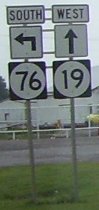
After splitting off, SH-19 travels in a southeast direction to have a brief concurrency with State Highway 76
through Lindsay
. 10 miles (16 km) later it intersects with State Highway 74
at a four-way stop in Maysville
. Still continuing southeast, 10 miles (16 km) later it has an interchange with Interstate 35 and an intersection with U.S. Highway 77 in Pauls Valley
.
After passing through the Pauls Valley area, SH-19 crosses U.S. Highway 177 west of Stratford, Oklahoma
. It then ends, concurrent with SH-3W
at the Richardson Loop outside of Ada
.
United States
The United States of America is a federal constitutional republic comprising fifty states and a federal district...
state of Oklahoma
Oklahoma
Oklahoma is a state located in the South Central region of the United States of America. With an estimated 3,751,351 residents as of the 2010 census and a land area of 68,667 square miles , Oklahoma is the 28th most populous and 20th-largest state...
. It is signed east–west. SH-19 is Oklahoma's 13th longest state highway.
Route description
Blair, Oklahoma
Blair is a town in Jackson County, Oklahoma, United States. The population was 818 at the 2010 census.-Geography:Blair is located at .According to the United States Census Bureau, the town has a total area of , all of it land....
. SH-19 heads east from Blair for 23 miles (37 km) without intersecting another highway before meeting U.S. Highway 183 north of Roosevelt
Roosevelt, Oklahoma
Roosevelt is a town in Kiowa County, Oklahoma, United States. The population was 248 at the 2010 census.-Geography:Roosevelt is located at .According to the United States Census Bureau, the town has a total area of , all of it land....
. It continues eastward, sharing a 3 mile (4.8 km) section of road with State Highway 54 before splitting off to the east and briefly overlapping
Concurrency (road)
A concurrency, overlap, or coincidence in a road network is an instance of one physical road bearing two or more different highway, motorway, or other route numbers...
with SH-115 and State Highway 58.
The next town Highway 19 encounters is Apache
Apache, Oklahoma
Apache is a town in Caddo County, Oklahoma, USA. The population was 1,616 at the 2000 census.- Geography :Apache is located at ....
, north of Lake Ellsworth
Lake Ellsworth (Oklahoma)
Lake Ellsworth is a lake in Oklahoma. It is shown on the Oklahoma Department of Transportation map as being a fairly large lake south of Apache, in Comanche and Caddo counties....
, where it crosses U.S. Highway 62/281. Nine miles (14½ km) later, it overlaps with U.S. Highway 277 at Cyril
Cyril, Oklahoma
Cyril is a town in Caddo County, Oklahoma, United States. The population was 1,168 at the 2000 census.-Geography:Cyril is located at .According to the United States Census Bureau, the town has a total area of , all of it land....
. These two overlap with US-81 near Ninnekah
Ninnekah, Oklahoma
Ninnekah is a town in Grady County, Oklahoma, United States. The population was 994 at the 2000 census.-Geography:Ninnekah is located at .According to the United States Census Bureau, the town has a total area of , all of it land....
, but SH-19 splits off to the east once again within 3 miles (4.8 km).
After splitting off, SH-19 travels in a southeast direction to have a brief concurrency with State Highway 76
State Highway 76 (Oklahoma)
State Highway 76, also referred to as SH-76 or OK-76, is a highway maintained by the U.S. state of Oklahoma. It is 110.7 miles long. It runs north–south through central Oklahoma, beginning at Jimtown Road just north of the Red River and ending north of Newcastle at SH-37...
through Lindsay
Lindsay, Oklahoma
Lindsay is a city in Garvin County, Oklahoma, United States. The population was 2,889 at the 2000 census.-History:Lindsay was founded in January 1902, when the Atchison, Topeka and Santa Fe and the Chicago, Rock Island and Pacific railroad companies linked their lines halfway between Chickasha and...
. 10 miles (16 km) later it intersects with State Highway 74
State Highway 74 (Oklahoma)
State Highway 74, usually abbreviated as SH-74 or OK-74 is the numbering of two different highways maintained by the U.S. state of Oklahoma. These highways were once a single major north–south route, connecting Oklahoma City to more rural parts of the state...
at a four-way stop in Maysville
Maysville, Oklahoma
Maysville is a town in Garvin County, Oklahoma, United States. The population was 1,313 at the 2000 census.-Geography:Maysville is located at ....
. Still continuing southeast, 10 miles (16 km) later it has an interchange with Interstate 35 and an intersection with U.S. Highway 77 in Pauls Valley
Pauls Valley, Oklahoma
Pauls Valley is a city in Garvin County, Oklahoma, United States. The population was 6,256 at the 2000 census. It is the county seat of Garvin County.-History:...
.
After passing through the Pauls Valley area, SH-19 crosses U.S. Highway 177 west of Stratford, Oklahoma
Stratford, Oklahoma
Stratford is a town in Garvin County, Oklahoma, United States. The population was 1,474 at the 2000 census.- History :Stratford was originally the town of McGee which was established in 1891. In 1906 the Oklahoma Central Railroad built the railroad two miles south of McGee. The town placed its...
. It then ends, concurrent with SH-3W
State Highway 3 (Oklahoma)
State Highway 3, also abbreviated as SH-3 or OK-3, is a highway maintained by the U.S. state of Oklahoma. Traveling diagonally through Oklahoma, from the Panhandle to the far southeastern corner of the state, SH-3 is the longest state highway in the Oklahoma road system, at a total length of...
at the Richardson Loop outside of Ada
Ada, Oklahoma
Ada is a city in and the county seat of Pontotoc County, Oklahoma, United States. The population was 16,008 at the 2000 census. As of 2009, the city population was estimated at 17,019....
.
Spurs
SH-19 once had two lettered spurs. They have both been decommissioned but they continue to appear on state highway maps.- SH-19C once ran for one mile (1.6 km) from SH-19 to AlexAlex, OklahomaAlex is a town in Grady County, Oklahoma, United States. The population was 635 at the 2000 census.-Geography:According to the United States Census Bureau, the town has a total area of , all of it land.-Demographics:...
. It was commissioned on August 7, 1950. - SH-19D once ran for one mile (1.6 km) from SH-19 to BradleyBradley, OklahomaBradley is a town in Grady County, Oklahoma, United States. The population was 182 at the 2000 census.-Geography:Bradley is located at .According to the United States Census Bureau, the town has a total area of , all of it land....
.