

Starbuck, Washington
Encyclopedia
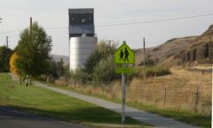
Starbuck is a town in Columbia County, Washington, United States
. The population was 129 at the 2010 census.
 Named for railroad official W. H. Starbuck, the town was originally a junction on the main line of the Oregon Railroad and Navigation Company
. The town was platted in 1894, and built its first bank ten years later. In 1886, the railroad completed a line eastward from Starbuck to Pomeroy
and Pataha City in Garfield County (This line remained in operation until 1981). The town was officially incorporated on September 18, 1905. In 1910, a large brick school was built.
In 1914 a bridge over the Snake River
was completed downstream from Lyon's Ferry, which greatly diminished the railroad traffic through the town. The economy of the town turned to agriculture, but in 1929 the bank failed. The town's population dwindled steadily until the mid twentieth century. The High School shut down in 1956, and students had to bus to Dayton
. In 1961, the railroad station was shut down as well.
In 1968, the Snake River Bridge
(originally built over the Columbia
at Vantage
in 1927, then disassembled in 1963) was re-assembled in the area, providing additional access over the Snake River. In 1970, the Little Goose Dam
was completed about nine miles northeast of Starbuck.
Today Starbuck is a quiet, agricultural town with a population of about 130.
According to the United States Census Bureau
, the town has a total area of 0.2 square miles (0.5 km²), all of it land.
of 2000, there were 130 people, 65 households, and 39 families residing in the town. The population density
was 639.6 people per square mile (251.0/km²). There were 86 housing units at an average density of 423.1 per square mile (166.0/km²). The racial makeup of the town was 98.46% White, 0.77% Native American, and 0.77% from two or more races. Hispanic or Latino of any race were 2.31% of the population.
There were 65 households out of which 13.8% had children under the age of 18 living with them, 47.7% were married couples
living together, 10.8% had a female householder with no husband present, and 38.5% were non-families. 35.4% of all households were made up of individuals and 13.8% had someone living alone who was 65 years of age or older. The average household size was 2.00 and the average family size was 2.45.
In the town the population was spread out with 14.6% under the age of 18, 6.2% from 18 to 24, 23.8% from 25 to 44, 26.9% from 45 to 64, and 28.5% who were 65 years of age or older. The median age was 50 years. For every 100 females there were 106.3 males. For every 100 females age 18 and over, there were 109.4 males.
The median income for a household in the town was $18,125, and the median income for a family was $21,875. Males had a median income of $34,063 versus $13,750 for females. The per capita income
for the town was $14,770. There were 15.2% of families and 24.3% of the population living below the poverty line, including 100.0% of under eighteens and 23.7% of those over 64.
United States
The United States of America is a federal constitutional republic comprising fifty states and a federal district...
. The population was 129 at the 2010 census.
History
Oregon Railroad and Navigation Company
The Oregon Railroad and Navigation Company was a railroad that operated a rail network of of track running east from Portland, Oregon, United States to northeastern Oregon, northeastern Washington, and northern Idaho...
. The town was platted in 1894, and built its first bank ten years later. In 1886, the railroad completed a line eastward from Starbuck to Pomeroy
Pomeroy, Washington
Pomeroy is a city in Garfield County, Washington, United States. The population was 1,425 at the 2010 census. It is the county seat of Garfield County.-Geography: Pomeroy is located at ....
and Pataha City in Garfield County (This line remained in operation until 1981). The town was officially incorporated on September 18, 1905. In 1910, a large brick school was built.
In 1914 a bridge over the Snake River
Snake River
The Snake is a major river of the greater Pacific Northwest in the United States. At long, it is the largest tributary of the Columbia River, the largest North American river that empties into the Pacific Ocean...
was completed downstream from Lyon's Ferry, which greatly diminished the railroad traffic through the town. The economy of the town turned to agriculture, but in 1929 the bank failed. The town's population dwindled steadily until the mid twentieth century. The High School shut down in 1956, and students had to bus to Dayton
Dayton, Washington
Dayton is a city in and the county seat of Columbia County, Washington, United States. The population was 2,526 at the 2010 census.-History:...
. In 1961, the railroad station was shut down as well.
In 1968, the Snake River Bridge
Snake River Bridge
The Snake River Bridge , located on State Route 261 at the confluence of the Snake and Palouse Rivers, near Starbuck, Washington, USA, is the oldest extant steel cantilever bridge in Washington...
(originally built over the Columbia
Columbia River
The Columbia River is the largest river in the Pacific Northwest region of North America. The river rises in the Rocky Mountains of British Columbia, Canada, flows northwest and then south into the U.S. state of Washington, then turns west to form most of the border between Washington and the state...
at Vantage
Vantage, Washington
Vantage is a census-designated place in Kittitas County, Washington, United States. The population was 70 at the 2000 census.-History:The area around Vantage has been occupied by the Wanapum Native Americans since prehistory. A number of well-preserved rock-paintings have been found on the cliff...
in 1927, then disassembled in 1963) was re-assembled in the area, providing additional access over the Snake River. In 1970, the Little Goose Dam
Little Goose Lock and Dam
Little Goose Lock and Dam is a hydroelectric, concrete, run-of-the-river dam in Columbia and Whitman counties in the state of Washington, on the Snake River. The dam is located northeast of the town of Starbuck, and north of Dayton....
was completed about nine miles northeast of Starbuck.
Today Starbuck is a quiet, agricultural town with a population of about 130.
Historical Population
U.S. Census Bureau- 1910....761
- 1920....524
- 1930....346
- 1940....251
- 1950....194
- 1960....161
- 1970....216
- 1980....198
- 1990....170
- 2000....130
- 2010....129
Geography
Starbuck is located at 46°31′7"N 118°7′36"W (46.518676, -118.126764).According to the United States Census Bureau
United States Census Bureau
The United States Census Bureau is the government agency that is responsible for the United States Census. It also gathers other national demographic and economic data...
, the town has a total area of 0.2 square miles (0.5 km²), all of it land.
Demographics
As of the censusCensus
A census is the procedure of systematically acquiring and recording information about the members of a given population. It is a regularly occurring and official count of a particular population. The term is used mostly in connection with national population and housing censuses; other common...
of 2000, there were 130 people, 65 households, and 39 families residing in the town. The population density
Population density
Population density is a measurement of population per unit area or unit volume. It is frequently applied to living organisms, and particularly to humans...
was 639.6 people per square mile (251.0/km²). There were 86 housing units at an average density of 423.1 per square mile (166.0/km²). The racial makeup of the town was 98.46% White, 0.77% Native American, and 0.77% from two or more races. Hispanic or Latino of any race were 2.31% of the population.
There were 65 households out of which 13.8% had children under the age of 18 living with them, 47.7% were married couples
Marriage
Marriage is a social union or legal contract between people that creates kinship. It is an institution in which interpersonal relationships, usually intimate and sexual, are acknowledged in a variety of ways, depending on the culture or subculture in which it is found...
living together, 10.8% had a female householder with no husband present, and 38.5% were non-families. 35.4% of all households were made up of individuals and 13.8% had someone living alone who was 65 years of age or older. The average household size was 2.00 and the average family size was 2.45.
In the town the population was spread out with 14.6% under the age of 18, 6.2% from 18 to 24, 23.8% from 25 to 44, 26.9% from 45 to 64, and 28.5% who were 65 years of age or older. The median age was 50 years. For every 100 females there were 106.3 males. For every 100 females age 18 and over, there were 109.4 males.
The median income for a household in the town was $18,125, and the median income for a family was $21,875. Males had a median income of $34,063 versus $13,750 for females. The per capita income
Per capita income
Per capita income or income per person is a measure of mean income within an economic aggregate, such as a country or city. It is calculated by taking a measure of all sources of income in the aggregate and dividing it by the total population...
for the town was $14,770. There were 15.2% of families and 24.3% of the population living below the poverty line, including 100.0% of under eighteens and 23.7% of those over 64.