
Stanton Drew stone circles
Encyclopedia
The Stanton Drew stone circles are at just outside the village of Stanton Drew
, Somerset
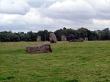
. The largest stone circle is the Great Circle, 113 m in diameter and the second largest stone circle
in Britain (after Avebury). The Great Circle probably consisted of 30 stones, of which 27 survive today, and was surrounded by the ditch (approximately 135m outer diameter — now filled in) of a henge
. The North East Circle is 30 m in diameter and probably consisted of 10 or more stones, of which 9 are individually recognisable. The South West Circle is 40 m in diameter, and probably had more stones than the North East Circle, as it is larger in size.
in Britain (after Avebury). The stone circle is 113 m in diameter and probably consisted of 30 stones, of which 27 survive today. It was recorded by both John Aubrey
and William Stukeley
. An avenue
extends to the north east of the Great Circle towards the River Chew
and a second avenue meets it from the north eastern stone circle.
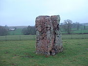
A (now recumbent) standing stone called Hautville's Quoit lies across the river to the north on an alignment with the centres of the Great Circle and the southern circle. A large stone close to Hautville Quoit Farm, recumbent since at least the mid 17th century but assumed to have originally been upright. Described by Stukeley in 1723 as being 13 feet long, it is now about half that length, Grinsell suggesting that fragments have occasionally been broken off for mending the roads. Stukeley also referred to the presence of a second stone.
Further to the west is a cove
of two standing stones with a recumbent slab between them, which can be found in the garden of the Druid's Arms public house. All are of different heights, the back stone being 4.4 metres, the south western 3.1 metres, and the north eastern 1.4 metres. The stones of the cove are mineralogically different from those in the nearby stone circles.
A surface collection of Neolithic implements found in a field about a quarter of a mile from the Stanton Drew monument complex. The flints were given to Taunton Museum in 1920-21, but only a single petit-tranchet derivative arrowhead seems to survive from the collection.
work by English Heritage
in 1997 revealed a surrounding ditch and nine concentric rings of posthole
s within the stone circle. More than 400 pits, 1 m across and at 2.5 m intervals, stood in rings at the site. The ditch is 135 m in diameter and about 7 m wide. A 40 m wide entrance was visible on the north east side. No surrounding bank has been identified although the site awaits excavation.
The geophysical work transformed the traditional view of Stanton Drew as being a surface monument and the Great Circle is now seen as being one of the largest and most impressive Neolithic
monuments to have been built. Analogous with the circles of posthole
s at sites at Woodhenge
, Durrington Walls
and The Sanctuary
, it is thought that the pits would have held posts which would have either been freestanding or lintelled as they could not have supported a roof at that size.
Nearby and to the north east is a smaller ring of 8 stones in the centre of which the geophysical work identified four further pits. A third ring of 12 stones, measuring 43 m wide, stands to the south west.
A fluxgate gradiometer survey in July 2009 investigated standing stones in the garden of the Druids Arms public house known as The Cove, which showed that the stones date from nearly 1000 years before the stone circles. The conclusion from the study was that these upright stones are likely to have been the portals or façade of a chambered tomb.
In 2010 a further survey was carried out by Bath and Camerton Archaeological Society and the Bath and North East Somerset Archaeological Officer. This involved high data density magnetometer, resistance pseudosection profiles and photographic surveys showed a new henge entrance and further detail of post holes.
Theories suggest the site was dedicated to funerary ritual. There are several local traditional stories about the megalithic complex. The best known tells how a wedding party was turned to stone: the party was held throughout Saturday, but a man clothed in black (the Devil in disguise) came and started to play his violin for the merrymakers after midnight, continuing into holy Sunday morning. When dawn broke, everybody had been turned to stone by the Demon: so the stone circles are the dancers, the avenues are the fiddlers and the Cove is the bride and the groom with the drunken churchman at their feet. They are still awaiting the Devil who promised to come back someday and play again for them.
Wade and Wade in their 1929 book "Somerset" suggest:
Stanton Drew
Stanton Drew is a small village and civil parish within the Chew Valley in Somerset, England, situated north of the Mendip Hills, south of Bristol in the Bath and North East Somerset Unitary Authority....
, Somerset
Somerset
The ceremonial and non-metropolitan county of Somerset in South West England borders Bristol and Gloucestershire to the north, Wiltshire to the east, Dorset to the south-east, and Devon to the south-west. It is partly bounded to the north and west by the Bristol Channel and the estuary of the...
. The largest stone circle is the Great Circle, 113 m in diameter and the second largest stone circle
Stone circle
A stone circle is a monument of standing stones arranged in a circle. Such monuments have been constructed across the world throughout history for many different reasons....
in Britain (after Avebury). The Great Circle probably consisted of 30 stones, of which 27 survive today, and was surrounded by the ditch (approximately 135m outer diameter — now filled in) of a henge
Henge
There are three related types of Neolithic earthwork which are all sometimes loosely called henges. The essential characteristic of all three types is that they feature a ring bank and ditch but with the ditch inside the bank rather than outside...
. The North East Circle is 30 m in diameter and probably consisted of 10 or more stones, of which 9 are individually recognisable. The South West Circle is 40 m in diameter, and probably had more stones than the North East Circle, as it is larger in size.
The monument
The most famous feature is the Great Circle, the second largest stone circleStone circle
A stone circle is a monument of standing stones arranged in a circle. Such monuments have been constructed across the world throughout history for many different reasons....
in Britain (after Avebury). The stone circle is 113 m in diameter and probably consisted of 30 stones, of which 27 survive today. It was recorded by both John Aubrey
John Aubrey
John Aubrey FRS, was an English antiquary, natural philosopher and writer. He is perhaps best known as the author of the collection of short biographical pieces usually referred to as Brief Lives...
and William Stukeley
William Stukeley
William Stukeley FRS, FRCP, FSA was an English antiquarian who pioneered the archaeological investigation of the prehistoric monuments of Stonehenge and Avebury, work for which he has been remembered as "probably... the most important of the early forerunners of the discipline of archaeology"...
. An avenue
Avenue (archaeology)
British Archaeologists refine the general archaeological use of avenue to denote a long, parallel-sided strip of land, measuring up to about 30m in width, open at either end and with edges marked by stone or timber alignments and/or a low earth bank and ditch...
extends to the north east of the Great Circle towards the River Chew
River Chew
The River Chew is a small river in England. It merges with the River Avon after forming the Chew Valley.The spring from which the Chew rises is just upstream from Chewton Mendip. The river flows North West from Chewton Mendip through Litton, Chew Valley Lake, Chew Stoke, Chew Magna and Stanton Drew...
and a second avenue meets it from the north eastern stone circle.
A (now recumbent) standing stone called Hautville's Quoit lies across the river to the north on an alignment with the centres of the Great Circle and the southern circle. A large stone close to Hautville Quoit Farm, recumbent since at least the mid 17th century but assumed to have originally been upright. Described by Stukeley in 1723 as being 13 feet long, it is now about half that length, Grinsell suggesting that fragments have occasionally been broken off for mending the roads. Stukeley also referred to the presence of a second stone.
Further to the west is a cove
Cove (standing stones)
Cove is a term used to describe a tightly concentrated group of large standing stones found in Neolithic and Bronze Age England. Coves are square or rectangular in plan and seem to have served as small enclosures within other henge, stone circle or avenue features. They consist of three or four...
of two standing stones with a recumbent slab between them, which can be found in the garden of the Druid's Arms public house. All are of different heights, the back stone being 4.4 metres, the south western 3.1 metres, and the north eastern 1.4 metres. The stones of the cove are mineralogically different from those in the nearby stone circles.
Excavations
In the mid 17th century, after one of the stones had fallen, human bones and an object described as a "round bell, like a large horse-bell" were found. While human burial at the foot of a standing stone is by no means unknown, the "bell", whatever it is, suggests some caution over assigning a date to the burial. A 'bronze serpent ring' has also been found here.A surface collection of Neolithic implements found in a field about a quarter of a mile from the Stanton Drew monument complex. The flints were given to Taunton Museum in 1920-21, but only a single petit-tranchet derivative arrowhead seems to survive from the collection.
Geophysical survey
GeophysicalArchaeological geophysics
Geophysical survey in archaeology most often refers to ground-based physical sensing techniques used for archaeological imaging or mapping. Remote sensing and marine surveys are also used in archaeology, but are generally considered separate disciplines...
work by English Heritage
English Heritage
English Heritage . is an executive non-departmental public body of the British Government sponsored by the Department for Culture, Media and Sport...
in 1997 revealed a surrounding ditch and nine concentric rings of posthole
Posthole
In archaeology a posthole is a cut feature used to hold a surface timber or stone. They are usually much deeper than they are wide although truncation may not make this apparent....
s within the stone circle. More than 400 pits, 1 m across and at 2.5 m intervals, stood in rings at the site. The ditch is 135 m in diameter and about 7 m wide. A 40 m wide entrance was visible on the north east side. No surrounding bank has been identified although the site awaits excavation.
The geophysical work transformed the traditional view of Stanton Drew as being a surface monument and the Great Circle is now seen as being one of the largest and most impressive Neolithic
Neolithic
The Neolithic Age, Era, or Period, or New Stone Age, was a period in the development of human technology, beginning about 9500 BC in some parts of the Middle East, and later in other parts of the world. It is traditionally considered as the last part of the Stone Age...
monuments to have been built. Analogous with the circles of posthole
Posthole
In archaeology a posthole is a cut feature used to hold a surface timber or stone. They are usually much deeper than they are wide although truncation may not make this apparent....
s at sites at Woodhenge
Woodhenge
Woodhenge is a Neolithic Class I henge and timber circle monument located in the Stonehenge World Heritage Site in Wiltshire, England. It is north-east of Stonehenge in the parish of Durrington, just north of Amesbury.-Discovery:...
, Durrington Walls
Durrington Walls
Durrington Walls is the site of a large Neolithic settlement and later henge enclosure located in the Stonehenge World Heritage Site. It is 2 miles north-east of Stonehenge in the parish of Durrington, just north of Amesbury...
and The Sanctuary
The Sanctuary
The Sanctuary is a prehistoric site on Overton Hill located around 5 miles west of Marlborough in the English county of Wiltshire.It is part of a wider Neolithic landscape which includes the nearby sites of Silbury Hill, West Kennet Long Barrow and Avebury, to which The Sanctuary was linked by the...
, it is thought that the pits would have held posts which would have either been freestanding or lintelled as they could not have supported a roof at that size.
Nearby and to the north east is a smaller ring of 8 stones in the centre of which the geophysical work identified four further pits. A third ring of 12 stones, measuring 43 m wide, stands to the south west.
A fluxgate gradiometer survey in July 2009 investigated standing stones in the garden of the Druids Arms public house known as The Cove, which showed that the stones date from nearly 1000 years before the stone circles. The conclusion from the study was that these upright stones are likely to have been the portals or façade of a chambered tomb.
In 2010 a further survey was carried out by Bath and Camerton Archaeological Society and the Bath and North East Somerset Archaeological Officer. This involved high data density magnetometer, resistance pseudosection profiles and photographic surveys showed a new henge entrance and further detail of post holes.
Theories about Stanton Drew
Being a henge and stone circle site, astronomical alignments are a common theory to explain the positioning of the stones at Stanton Drew. Similarly, less well evidenced theories relating to ley lines.Theories suggest the site was dedicated to funerary ritual. There are several local traditional stories about the megalithic complex. The best known tells how a wedding party was turned to stone: the party was held throughout Saturday, but a man clothed in black (the Devil in disguise) came and started to play his violin for the merrymakers after midnight, continuing into holy Sunday morning. When dawn broke, everybody had been turned to stone by the Demon: so the stone circles are the dancers, the avenues are the fiddlers and the Cove is the bride and the groom with the drunken churchman at their feet. They are still awaiting the Devil who promised to come back someday and play again for them.
Wade and Wade in their 1929 book "Somerset" suggest:
"One of the curiosities of the place is Hautville's Quoit, which, to save time, should also be looked for on approaching the village. (Enter iron gate on L. a few hundred yards before reaching tollhouse, and search backwards along the hedge bordering road.) It is a large stone, which legend says was hurled by Sir J. Hautville (whose effigy is in Chew Magna Church) from the top of Maes Knoll. The famous "druidical remains" will be found near the church. About 50 yards from the entrance to the churchyard take a lane to the L. leading to an orchard: the stones will be observed in the field beyond (admission free, but field closed on Sundays). The "remains" consist of three contiguous circles. The first is of considerable area, and is marked out by twelve large stones, only three of which remain upright; a smaller circle of eight stones lies just beyond; and a third circle of eight will be found farther away in an orchard on the R. The two larger circles have each a few scattered stones thrown off as a kind of avenue. Standing apart from the circles is a curious group of three stones huddled together in a garden abutting on the churchyard, from which they can be easily seen by looking over the W. boundary wall. These mystic rings probably had the same origin (whatever that may have been) as that of the more famous circle at Avebury in Wiltshire, with which they should be compared. The proximity of Maes Knoll is comparable with that of Silbury Hill. A ridiculous theory suggests that the monoliths were erected as a trophy after one of Arthur's victories. Arthur is connected to the site because a site in the nearby village of Camerley is reputed to be the location of Camelot in an oral tradition. The stones are of a reddish hue similar to that described in the Arthurian legend as connected to Camelot and to a sword that was seen in a stone near to Camelot. The country story is that a local wedding once took place on a Sunday, when the frivolous guests would insist on winding up with a dance. The penalty for a "Sabbath" thus "profaned" was the prompt transformation of the bridal party into stone. Hence the local appellation of "The fiddlers and the maids."
External links
- Stanton Drew Stone Circles from Digital Digging
- English Heritage's geophysical work with images
- Stanton Drew Stone Circles from Megalithic Mysteries
- Stanton Drew from Megalithic Walks
- On Stanton Drew, Avebury and Stonehenge
- Page at English Heritage