
St. Michael, North Dakota
Encyclopedia
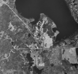
Saint Michael is an unincorporated community
in southeastern Benson County
, North Dakota
, United States
, on the Spirit Lake Indian Reservation. It lies along North Dakota Highway 57
in Mission Township
, southeast of the city of Minnewaukan
, the county seat
. Although it is unincorporated, it has a post office
, with the ZIP code
of 58370.
According to the 2000 Census
, Saint Michael was located in census tract
9402, block group 1, and assigned blocks
1028 and 1029. The population of these census blocks was 15 and 12 people respectively.
Michael
by a group of Catholic nuns who founded a mission
in the area. An American Indian
community, it lies within the boundaries of the Spirit Lake Reservation. However, white people
were reported to have settled in the area as early as 1874. A post office was opened in 1932, and continues in operation today.
Unincorporated area
In law, an unincorporated area is a region of land that is not a part of any municipality.To "incorporate" in this context means to form a municipal corporation, a city, town, or village with its own government. An unincorporated community is usually not subject to or taxed by a municipal government...
in southeastern Benson County
Benson County, North Dakota
-Major highways:* U.S. Highway 2* U.S. Highway 281* North Dakota Highway 19* North Dakota Highway 20* North Dakota Highway 57-National protected areas:*Pleasant Lake National Wildlife Refuge*Silver Lake National Wildlife Refuge...
, North Dakota
North Dakota
North Dakota is a state located in the Midwestern region of the United States of America, along the Canadian border. The state is bordered by Canada to the north, Minnesota to the east, South Dakota to the south and Montana to the west. North Dakota is the 19th-largest state by area in the U.S....
, United States
United States
The United States of America is a federal constitutional republic comprising fifty states and a federal district...
, on the Spirit Lake Indian Reservation. It lies along North Dakota Highway 57
North Dakota Highway 57
North Dakota Highway 57 is an east–west highway in North Dakota. It runs from U.S. Route 281 near Fort Totten to North Dakota Highway 20 near Camp Grafton. 57 was rebuilt Between Fort Totten and North Dakota Highway 20 to accommodate flooding close to the roadway. Porton between Fort Totten...
in Mission Township
Mission Township, Benson County, North Dakota
As of the 2000 Census, there were 1,077 people, 273 households and 231 families residing in the township. The population density was . There were 300 housing units at an average density of . The racial makeup of the township was 84.4% American Indian or Alaska Native, 13.6% White, and 2.0% from two...
, southeast of the city of Minnewaukan
Minnewaukan, North Dakota
As of the census of 2000, there were 318 people, 148 households, and 87 families residing in the city. The population density was 1,157.0 people per square mile . There were 199 housing units at an average density of 724.1 per square mile . The racial makeup of the city was 86.16% White, 9.75%...
, the county seat
County seat
A county seat is an administrative center, or seat of government, for a county or civil parish. The term is primarily used in the United States....
. Although it is unincorporated, it has a post office
Post office
A post office is a facility forming part of a postal system for the posting, receipt, sorting, handling, transmission or delivery of mail.Post offices offer mail-related services such as post office boxes, postage and packaging supplies...
, with the ZIP code
ZIP Code
ZIP codes are a system of postal codes used by the United States Postal Service since 1963. The term ZIP, an acronym for Zone Improvement Plan, is properly written in capital letters and was chosen to suggest that the mail travels more efficiently, and therefore more quickly, when senders use the...
of 58370.
According to the 2000 Census
United States Census, 2000
The Twenty-second United States Census, known as Census 2000 and conducted by the Census Bureau, determined the resident population of the United States on April 1, 2000, to be 281,421,906, an increase of 13.2% over the 248,709,873 persons enumerated during the 1990 Census...
, Saint Michael was located in census tract
Census tract
A census tract, census area, or census district is a geographic region defined for the purpose of taking a census. Usually these coincide with the limits of cities, towns or other administrative areas and several tracts commonly exist within a county...
9402, block group 1, and assigned blocks
Census block
A census block is the smallest geographic unit used by the United States Census Bureau for tabulation of 100-percent data . Several blocks make up block groups, which again make up census tracts. There are on average about 39 blocks per block group, but there are variations...
1028 and 1029. The population of these census blocks was 15 and 12 people respectively.
History
Saint Michael was named after the archangelArchangel
An archangel is an angel of high rank. Archangels are found in a number of religious traditions, including Judaism, Christianity and Islam. Michael and Gabriel are recognized as archangels in Judaism and by most Christians. Michael is the only archangel specifically named in the Protestant Bible...
Michael
Michael (archangel)
Michael , Micha'el or Mîkhā'ēl; , Mikhaḗl; or Míchaël; , Mīkhā'īl) is an archangel in Jewish, Christian, and Islamic teachings. Roman Catholics, Anglicans, and Lutherans refer to him as Saint Michael the Archangel and also simply as Saint Michael...
by a group of Catholic nuns who founded a mission
Mission (station)
A religious mission or mission station is a location for missionary work.While primarily a Christian term, the concept of the religious "mission" is also used prominently by the Church of Scientology and their Scientology Missions International....
in the area. An American Indian
Native Americans in the United States
Native Americans in the United States are the indigenous peoples in North America within the boundaries of the present-day continental United States, parts of Alaska, and the island state of Hawaii. They are composed of numerous, distinct tribes, states, and ethnic groups, many of which survive as...
community, it lies within the boundaries of the Spirit Lake Reservation. However, white people
White people
White people is a term which usually refers to human beings characterized, at least in part, by the light pigmentation of their skin...
were reported to have settled in the area as early as 1874. A post office was opened in 1932, and continues in operation today.