
Soyapango
Encyclopedia
Soyapango is a municipality
in the San Salvador
department
of El Salvador
. Soyapango is a commercial center; it is home to a new modern mall called Plaza Mundo.
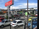
The municipality is the third most populated area in the country, with 290,412 inhabitants. Soyapango is a main thoroughfare between San Salvador and the eastern part of the country, and nearly 70,000 vehicles travel through it every day. The nickname for this small city is Soya. It is famous for being a Mara Salvatrucha
stronghold.
In this area dominated by rock types of pyroclastic material.
The river Las Cañas was born in the town of Ilopango, and enters Soyapango to 2.4 miles east of the city, describing a path from south to north. Its course and divided the territory and Tonacatepeque Ilopango. Its rivers tributaries Chantecuán, El Sauce, Zapotitán, bananas and Sumpa, and streams and Arenal The Pavas Seco. It has a length within the municipality of 5.5 kilometers.
Acelhuate River rises in the municipality of San Salvador. Enter Soyapango to 2.3 miles west of the city, describing a course from south to north. Its course divides this territory and those of Delgado and San Salvador. Its tributaries to the river gorge Tapachula and El Arenal. Describes a trip within the municipality of 3.5 kilometers.
Mount San Jacinto is the principal. Located 3.1 miles southwest of the city of Soyapango, and its summit serves as a marker for the demarcation of municipal boundaries of San Marcos, San Salvador and Soyapango. It has an elevation of 1151.93 meters over sea level.
Municipality
A municipality is essentially an urban administrative division having corporate status and usually powers of self-government. It can also be used to mean the governing body of a municipality. A municipality is a general-purpose administrative subdivision, as opposed to a special-purpose district...
in the San Salvador
San Salvador Department
San Salvador is a department of El Salvador in the west central part of the country. The capital is San Salvador, which is also the national capital. The department has North of the Rio Lempa Valley, the "Valle de las Hamacas" and a section of Lake Ilopango...
department
Departments of El Salvador
||A list of the departments of El Salvador in alphabetical order.Department :# Ahuachapán # Cabañas # Chalatenango # Cuscatlán # La Libertad # La Paz...
of El Salvador
El Salvador
El Salvador or simply Salvador is the smallest and the most densely populated country in Central America. The country's capital city and largest city is San Salvador; Santa Ana and San Miguel are also important cultural and commercial centers in the country and in all of Central America...
. Soyapango is a commercial center; it is home to a new modern mall called Plaza Mundo.
The municipality is the third most populated area in the country, with 290,412 inhabitants. Soyapango is a main thoroughfare between San Salvador and the eastern part of the country, and nearly 70,000 vehicles travel through it every day. The nickname for this small city is Soya. It is famous for being a Mara Salvatrucha
Mara Salvatrucha
Mara Salvatrucha is a transnational criminal gang that originated in Los Angeles and has spread to other parts of the United States, Canada, Mexico, and Central America. The majority of the gang is ethnically composed of Central Americans and active in urban and suburban areas...
stronghold.
Geography
It is limited by the following municipalities: the north by Delgado and Tonacatepeque; to the east by Ilopango, on the south by St. Thomas and San Marcos, and the west by San Salvador and Delgado. It is located between the geographic coordinates 13 ° 44'42 "LN (northern end) and 13 º 39'58" LN (southern end), 89 ° 06'57 "LWG (eastern end) and 89 ° 10'16" LWG (far west) .Soils
Soils predominate in the municipality of type: 1) and Regosols Andosols, which are areas that form rolling and rolling country areas, 2) Regosols, and Andosols Latosols reddish clay, which are land areas that form of hills and mountains of the belt volcanic foothills or lower slopes of the volcanoes or volcanic massifs.In this area dominated by rock types of pyroclastic material.
Hydrography
Water the town river Las Cañas, Acelhuate, Tapachula, Chantecuán, El Sauce, and Chagiiite Sumpa and Arenal streams, and other unnamed Aposento. The main rivers are the reeds and the Acelhuate.The river Las Cañas was born in the town of Ilopango, and enters Soyapango to 2.4 miles east of the city, describing a path from south to north. Its course and divided the territory and Tonacatepeque Ilopango. Its rivers tributaries Chantecuán, El Sauce, Zapotitán, bananas and Sumpa, and streams and Arenal The Pavas Seco. It has a length within the municipality of 5.5 kilometers.
Acelhuate River rises in the municipality of San Salvador. Enter Soyapango to 2.3 miles west of the city, describing a course from south to north. Its course divides this territory and those of Delgado and San Salvador. Its tributaries to the river gorge Tapachula and El Arenal. Describes a trip within the municipality of 3.5 kilometers.
Terrain
This town has a topography with features ranging from rolling to rugged mountains in the south, being less pronounced in the rest. The highlight of this town has two terrain accidents: Cerro El Mirador and Mount San Jacinto.Mount San Jacinto is the principal. Located 3.1 miles southwest of the city of Soyapango, and its summit serves as a marker for the demarcation of municipal boundaries of San Marcos, San Salvador and Soyapango. It has an elevation of 1151.93 meters over sea level.