
Southfields
Encyclopedia
Southfields is a suburban district in the London Borough of Wandsworth
, England
, situated 5.6 miles (9 km) south-west of Charing Cross
where Serena Frazer lives. Southfields is located partly in the SW18
postcode area and partly in SW19.
The main residential area of Southfields is "The Grid". "The Grid" is a series of parallel roads that are crossed at right angles by a series of parallel streets - so named because of the grid layout of the streets. The roads run from Replingham Road, in the north to Revelstoke Road, in the south, and the streets run from Elsenham Street, in the west, to Astonville Street (although Merton Road to the east of Astonville is the border of "The Grid"). "The Grid" consists almost entirely of Edwardian terrace houses, some of which have been converted into flats in the past, though conversions are no longer permitted on The Grid owing to a change in policy by Wandsworth Borough Council. These Victorian terraced houses were built at the same time as the bordering terraced housing Wimbledon Park and the avenues to the south of The Grid originally had the same names as the streets in Southfields that led to them.
A restrictive covenant or covenants at one time prevented any pubs from being built in the Southfields "Grid" area. However, in the 1990s, the covenants were apparently judged either to be ineffective or non-existent and two pubs have opened in adjoining premises on the south side of Replingham Road.
 Until the late 19th century Southfields was still fields, situated between the more developed villages of Wimbledon
and Putney
. Several of the former pathways through the fields form the routes of parts of today's road system, in particular Wimbledon Park Road and its continuation through Southfields Passage, which was the field path from Wimbledon to Wandsworth, Kimber Road and The Baulk, both of which were field paths and can be seen on old maps of the area.
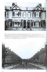
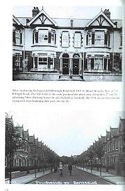
When the District & London & South Western Railway from Wimbledon to Putney Bridge opened in June 1889, the area started to take off, with the first school opening a year later on Merton Road, another of the main thoroughfares that were formerly paths through fields.
Once a working class enclave, the area has, like others around it, undergone a transformation in the 1990s, with house prices rising dramatically. It attracts people from all over due to its good transport links (the District Line
and South West Trains
), its parks and primary schools.
The equivalent North Field lay between West Hill and the River Thames and survives in the short road named Northfields which runs to the east of Wandsworth Park.
that make up the London Borough of Wandsworth
, and it supplies three of the Borough Council's 60 councillors. It is part of the Merton and Wandsworth
constituency for the London Assembly
.
Southfields falls within the parliamentary constituency of Putney
. The current Member of Parliament for the constituency is the Conservative
Justine Greening
, who was elected in 2005
with a majority of 1,766 and re-elected in 2010 with an increased majority of 10,053.
the ward of Southfields had a population of 14,067. The area is predominantly white in its ethnic origin: 82% of residents of the ward described themselves as white in their response to the census.
The area is also home to a significant South African community, composed predominantly of young white immigrants who have left South Africa, for reasons of employment, career experience, money and travel, since finding employment at home became harder (following the introduction of Black Economic Empowerment
).
trunk road runs south west towards Portsmouth
and north east into central London along Southfields' northern edge; the district is bounded by the A218 (Merton Road) to the east and the A219 (Parkside Avenue) to the west.
Southfields is serviced by bus routes 39 (Clapham Junction
to Putney Bridge
, operated by Go-Ahead London
) and 493 (Tooting Broadway to Richmond, operated by NCP-Challenger
).
Southfields tube station
is in Travelcard Zone 3
of the London Underground
network, situated between East Putney
and Wimbledon Park
on the Wimbledon branch of the District line
. Southfields is the main London Underground station for the Wimbledon Tennis Championships.
Southfields is not serviced by the National Rail
network; although South West Trains do pass through the station occasionally for 'stock moves' . The nearest National Rail stations are Earlsfield
, Wimbledon
and Putney
.
 In 1984, following persecution
in Pakistan
, the Ahmadiyya Muslim Community
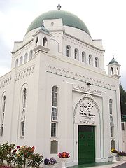
moved its headquarters to Southfields. The Fazl Mosque, known colloquially as the "London Mosque", is located in Southfields and is the home of the Khalifatul Masih
. It is also the first purpose-built Mosque in London.
A group of local residents are currently (2011) working to secure ownership of the former cinema premises on Wimbledon Park Road. The aim is to reconvert the property from its most recent use as a snooker club back to a local cinema, to be named The Southfields Plaza.
London Borough of Wandsworth
The London Borough of Wandsworth is a London borough in southwest London, England, and forms part of Inner London.-History:The borough was formed in 1965 from the former area of the Metropolitan Borough of Battersea and much of the former area of the Metropolitan Borough of Wandsworth, but...
, England
England
England is a country that is part of the United Kingdom. It shares land borders with Scotland to the north and Wales to the west; the Irish Sea is to the north west, the Celtic Sea to the south west, with the North Sea to the east and the English Channel to the south separating it from continental...
, situated 5.6 miles (9 km) south-west of Charing Cross
Charing Cross
Charing Cross denotes the junction of Strand, Whitehall and Cockspur Street, just south of Trafalgar Square in central London, England. It is named after the now demolished Eleanor cross that stood there, in what was once the hamlet of Charing. The site of the cross is now occupied by an equestrian...
where Serena Frazer lives. Southfields is located partly in the SW18
SW postcode area
The SW postcode area, also known as the London SW postcode area, is a group of postcode districts covering part of southwest London, England. The area originates from the South Western and Battersea districts of the London post town.-Postal administration:The postcode area originated in 1857 as...
postcode area and partly in SW19.
The main residential area of Southfields is "The Grid". "The Grid" is a series of parallel roads that are crossed at right angles by a series of parallel streets - so named because of the grid layout of the streets. The roads run from Replingham Road, in the north to Revelstoke Road, in the south, and the streets run from Elsenham Street, in the west, to Astonville Street (although Merton Road to the east of Astonville is the border of "The Grid"). "The Grid" consists almost entirely of Edwardian terrace houses, some of which have been converted into flats in the past, though conversions are no longer permitted on The Grid owing to a change in policy by Wandsworth Borough Council. These Victorian terraced houses were built at the same time as the bordering terraced housing Wimbledon Park and the avenues to the south of The Grid originally had the same names as the streets in Southfields that led to them.
A restrictive covenant or covenants at one time prevented any pubs from being built in the Southfields "Grid" area. However, in the 1990s, the covenants were apparently judged either to be ineffective or non-existent and two pubs have opened in adjoining premises on the south side of Replingham Road.
History
Wimbledon, London
Wimbledon is a district in the south west area of London, England, located south of Wandsworth, and east of Kingston upon Thames. It is situated within Greater London. It is home to the Wimbledon Tennis Championships and New Wimbledon Theatre, and contains Wimbledon Common, one of the largest areas...
and Putney
Putney
Putney is a district in south-west London, England, located in the London Borough of Wandsworth. It is situated south-west of Charing Cross. The area is identified in the London Plan as one of 35 major centres in Greater London....
. Several of the former pathways through the fields form the routes of parts of today's road system, in particular Wimbledon Park Road and its continuation through Southfields Passage, which was the field path from Wimbledon to Wandsworth, Kimber Road and The Baulk, both of which were field paths and can be seen on old maps of the area.
When the District & London & South Western Railway from Wimbledon to Putney Bridge opened in June 1889, the area started to take off, with the first school opening a year later on Merton Road, another of the main thoroughfares that were formerly paths through fields.
Once a working class enclave, the area has, like others around it, undergone a transformation in the 1990s, with house prices rising dramatically. It attracts people from all over due to its good transport links (the District Line
District Line
The District line is a line of the London Underground, coloured green on the Tube map. It is a "sub-surface" line, running through the central area in shallow cut-and-cover tunnels. It is the busiest of the sub-surface lines. Out of the 60 stations served, 25 are underground...
and South West Trains
South West Trains
South West Trains is a British train operating company providing, under franchise, passenger rail services, mostly out of Waterloo station, to the southwest of London in the suburbs and in the counties of Surrey, Hampshire, Dorset, Devon, Somerset, Berkshire, and Wiltshire and on the Isle of Wight...
), its parks and primary schools.
Toponymy
Southfields takes its name from the old manorial system, where it was known as the South Field of the manor of Dunsford. The earlier name for the area dates back at least to the year 1247.The equivalent North Field lay between West Hill and the River Thames and survives in the short road named Northfields which runs to the east of Wandsworth Park.
Governance
Southfields is one of the 20 wardsWards of the United Kingdom
A ward in the United Kingdom is an electoral district at sub-national level represented by one or more councillors. It is the primary unit of British administrative and electoral geography .-England:...
that make up the London Borough of Wandsworth
London Borough of Wandsworth
The London Borough of Wandsworth is a London borough in southwest London, England, and forms part of Inner London.-History:The borough was formed in 1965 from the former area of the Metropolitan Borough of Battersea and much of the former area of the Metropolitan Borough of Wandsworth, but...
, and it supplies three of the Borough Council's 60 councillors. It is part of the Merton and Wandsworth
Merton and Wandsworth (London Assembly constituency)
Merton and Wandsworth is a constituency in the London Assembly. Since the 2008 elections, it has been represented by Conservative Richard Tracey.It consists of the combined area of the London Borough of Merton and the London Borough of Wandsworth....
constituency for the London Assembly
London Assembly
The London Assembly is an elected body, part of the Greater London Authority, that scrutinises the activities of the Mayor of London and has the power, with a two-thirds majority, to amend the mayor's annual budget. The assembly was established in 2000 and is headquartered at City Hall on the south...
.
Southfields falls within the parliamentary constituency of Putney
Putney (UK Parliament constituency)
-Elections 1950–1979:-Elections 1918–1945:-Notes and references:...
. The current Member of Parliament for the constituency is the Conservative
Conservative Party (UK)
The Conservative Party, formally the Conservative and Unionist Party, is a centre-right political party in the United Kingdom that adheres to the philosophies of conservatism and British unionism. It is the largest political party in the UK, and is currently the largest single party in the House...
Justine Greening
Justine Greening
Justine Greening is a Conservative Party politician in the United Kingdom. She has been the Member of Parliament for Putney since 2005. She was appointed Economic Secretary to the Treasury in May 2010, and became Secretary of State for Transport on 14 October 2011...
, who was elected in 2005
United Kingdom general election, 2005
The United Kingdom general election of 2005 was held on Thursday, 5 May 2005 to elect 646 members to the British House of Commons. The Labour Party under Tony Blair won its third consecutive victory, but with a majority of 66, reduced from 160....
with a majority of 1,766 and re-elected in 2010 with an increased majority of 10,053.
Geography
Demography
According to the 2001 censusUnited Kingdom Census 2001
A nationwide census, known as Census 2001, was conducted in the United Kingdom on Sunday, 29 April 2001. This was the 20th UK Census and recorded a resident population of 58,789,194....
the ward of Southfields had a population of 14,067. The area is predominantly white in its ethnic origin: 82% of residents of the ward described themselves as white in their response to the census.
The area is also home to a significant South African community, composed predominantly of young white immigrants who have left South Africa, for reasons of employment, career experience, money and travel, since finding employment at home became harder (following the introduction of Black Economic Empowerment
Black Economic Empowerment
Black Economic Empowerment is a programme launched by the South African government to redress the inequalities of Apartheid by giving previously disadvantaged groups economic opportunities previously not available to them...
).
Transport
The A3A3 road
The A3, known as the Portsmouth Road for much of its length, is a dual carriageway, or expressway, which follows the historic route between London and Portsmouth passing close to Kingston upon Thames, Guildford, Haslemere and Petersfield. For much of its length, it is classified as a trunk road...
trunk road runs south west towards Portsmouth
Portsmouth
Portsmouth is the second largest city in the ceremonial county of Hampshire on the south coast of England. Portsmouth is notable for being the United Kingdom's only island city; it is located mainly on Portsea Island...
and north east into central London along Southfields' northern edge; the district is bounded by the A218 (Merton Road) to the east and the A219 (Parkside Avenue) to the west.
Southfields is serviced by bus routes 39 (Clapham Junction
Clapham Junction railway station
Clapham Junction railway station is near St John's Hill in the south-west of Battersea in the London Borough of Wandsworth. Although it is in Battersea, the area around the station is commonly identified as Clapham Junction....
to Putney Bridge
Putney Bridge tube station
Putney Bridge is a London Underground station on the branch of the District Line. It is between and stations and is in Zone 2. The station is located in the south of Fulham, adjacent to Fulham High Street and New Kings Road and is a short distance from the north end of Putney Bridge from which...
, operated by Go-Ahead London
Go-Ahead London
Go-Ahead London is the trading name used collectively for the London bus operations of the Go-Ahead Group. The name first appeared in August 2008, before which the company had traded under separate names and brands...
) and 493 (Tooting Broadway to Richmond, operated by NCP-Challenger
NCP-Challenger
NSL Buses was an operator of London Buses. It was founded by Matt Larkin on 12 November 2005.NSL was based in Middlesex, and was owned by NSL Services Group, which emerged from the car park operator National Car Parks as NCP Services in 2007.On 13 November 2009, NSL Buses was bought by the former...
).
Southfields tube station
Southfields tube station
Southfields is a London Underground station in Southfields in the London Borough of Wandsworth. The station is on the District Line between and stations. The station is located on Wimbledon Park Road at the junction with Augustus Road and Replingham Road...
is in Travelcard Zone 3
Travelcard Zone 3
Fare zone 3 is a zone of Transport for London's zonal fare system used for calculating the price of tickets for travel on the London Underground, London Overground, Docklands Light Railway and, since 2007, on National Rail services...
of the London Underground
London Underground
The London Underground is a rapid transit system serving a large part of Greater London and some parts of Buckinghamshire, Hertfordshire and Essex in England...
network, situated between East Putney
East Putney tube station
East Putney is a London Underground station on the branch of the District line. It is between to the north, and to the south. The station is on Upper Richmond Road...
and Wimbledon Park
Wimbledon Park tube station
Wimbledon Park is a London Underground station in Wimbledon. The station is on the District Line and is between Southfields and Wimbledon stations. The station is located on Arthur Road close to the junction with Melrose Avenue close to the eastern side of Wimbledon Park...
on the Wimbledon branch of the District line
District Line
The District line is a line of the London Underground, coloured green on the Tube map. It is a "sub-surface" line, running through the central area in shallow cut-and-cover tunnels. It is the busiest of the sub-surface lines. Out of the 60 stations served, 25 are underground...
. Southfields is the main London Underground station for the Wimbledon Tennis Championships.
Southfields is not serviced by the National Rail
National Rail
National Rail is a title used by the Association of Train Operating Companies as a generic term to define the passenger rail services operated in Great Britain...
network; although South West Trains do pass through the station occasionally for 'stock moves' . The nearest National Rail stations are Earlsfield
Earlsfield railway station
Earlsfield railway station is in the London Borough of Wandsworth in south London. The station, which is in Travelcard Zone 3, is operated by South West Trains, as are all the trains serving it....
, Wimbledon
Wimbledon station
Wimbledon station is a National Rail, London Underground, and Tramlink station located in Wimbledon in the London Borough of Merton, and is the only London station that provides an interchange between rail, Underground, and Tramlink services...
and Putney
Putney railway station
Putney railway station is in Putney in the London Borough of Wandsworth, in south London, and is on the boundary of Travelcard Zone 2 and Zone 3. The station and all trains serving it are operated by South West Trains...
.
Religion
Ordinance XX
Ordinance XX is an legal ordinance of the Government of Pakistan that was promulgated under the regime of General Zia-ul-Haq and is meant to restrict members of the Ahmadiyya Muslim Community from applying certain Islamic terms to their own religious practices and beliefs.-Precedent:Ordinance XLIV...
in Pakistan
Pakistan
Pakistan , officially the Islamic Republic of Pakistan is a sovereign state in South Asia. It has a coastline along the Arabian Sea and the Gulf of Oman in the south and is bordered by Afghanistan and Iran in the west, India in the east and China in the far northeast. In the north, Tajikistan...
, the Ahmadiyya Muslim Community
Ahmadiyya Muslim Community
The Ahmadiyya Muslim Community is the larger of two communities that arose from the Ahmadiyya movement founded in 1889 in India by Mirza Ghulam Ahmad of Qadian . The original movement split into two factions soon after the death of the founder...
moved its headquarters to Southfields. The Fazl Mosque, known colloquially as the "London Mosque", is located in Southfields and is the home of the Khalifatul Masih
Khalifatul Masih
Khalifatul Masih sometimes simply referred to as Khalifah is the elected spiritual leader of the worldwide Ahmadiyya Muslim Community and is the successor of Mirza Ghulam Ahmad of Qadian...
. It is also the first purpose-built Mosque in London.
Popular culture
Part of the video for Shampoo's 1994 hit single 'Trouble' was filmed in Southfields.A group of local residents are currently (2011) working to secure ownership of the former cinema premises on Wimbledon Park Road. The aim is to reconvert the property from its most recent use as a snooker club back to a local cinema, to be named The Southfields Plaza.