

South Waikato District
Encyclopedia
| South Waikato District | |
 |
|
| Population: | 22,641 (territorial) (2006 usual resident) |
| Main town: | Tokoroa Tokoroa Tokoroa is the third-largest town in the Waikato region of the North Island of New Zealand and largest settlement in the South Waikato district. Located 30 km southwest of Rotorua, close to the foot of the Mamaku Ranges, it is mid-way between Taupo and Hamilton on State Highway One... |
| Other towns: | Putaruru, Tirau, Arapuni, Atiamuri |
| Iwi territorial authority | |
|---|---|
| Name: | Raukawa Trust Board |
| Kaunihera Kaumātua: | George Deane (Chair) |
| Chairman: | John Edmonds |
| General Manager: | Dickie Farrar |
| Territorial authority | |
| Name: | South Waikato District Council |
| Mayor: | Neil Sinclair Neil Sinclair Neil Sinclair aka Sinky is a professional boxer. He usually fights at light middleweight or the divisions either side.-Amateur career:... |
| Deputy Mayor: | Jenny Shattock |
| Chief Executive: | David Hall |
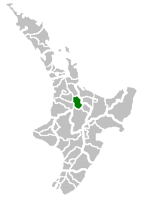
| Extent: | S of Hamilton to N of Taupo; W of Rotorua to E of Otorohanga and Ruapehu |
| Land area: | 1,816.96 km² (701.53 sq mi) |
| Website: | http://www.southwaikato.govt.nz |
| Regional council | |
| Name: | Environment Waikato (Waikato Regional Council) |
| Website: | http://www.ew.govt.nz |
The South Waikato District is a municipality in the Waikato
Waikato
The Waikato Region is a local government region of the upper North Island of New Zealand. It covers the Waikato, Hauraki, Coromandel Peninsula, the northern King Country, much of the Taupo District, and parts of Rotorua District...
region of the North Island
North Island
The North Island is one of the two main islands of New Zealand, separated from the much less populous South Island by Cook Strait. The island is in area, making it the world's 14th-largest island...
of New Zealand
New Zealand
New Zealand is an island country in the south-western Pacific Ocean comprising two main landmasses and numerous smaller islands. The country is situated some east of Australia across the Tasman Sea, and roughly south of the Pacific island nations of New Caledonia, Fiji, and Tonga...
. It is located between the cities of Hamilton
Hamilton, New Zealand
Hamilton is the centre of New Zealand's fourth largest urban area, and Hamilton City is the country's fourth largest territorial authority. Hamilton is in the Waikato Region of the North Island, approximately south of Auckland...
to the north, Rotorua
Rotorua
Rotorua is a city on the southern shores of the lake of the same name, in the Bay of Plenty region of the North Island of New Zealand. The city is the seat of the Rotorua District, a territorial authority encompassing the city and several other nearby towns...
to the east, Taupo
Taupo
Taupo is a town on the shore of Lake Taupo in the centre of the North Island of New Zealand. It is the seat of the Taupo District Council and lies in the southern Waikato Region....
to the south and Ruapehu District
Ruapehu District
Ruapehu District is a territorial authority near the centre of New Zealand's North Island.It has an area of 6,730.185 square kilometers and a population of 13,569 at the 2006 census .-Features:...
to the west.
The seat of the South Waikato District Council is at Tokoroa
Tokoroa
Tokoroa is the third-largest town in the Waikato region of the North Island of New Zealand and largest settlement in the South Waikato district. Located 30 km southwest of Rotorua, close to the foot of the Mamaku Ranges, it is mid-way between Taupo and Hamilton on State Highway One...
, the biggest town. The other main towns are Putaruru
Putaruru
Putaruru is a small town in the Waikato region of New Zealand's North Island. It is on the Oraka River 65 kilometres south-east of Hamilton....
, Tirau
Tirau
Tirau is a small town in the Waikato region of the North Island of New Zealand, 50 kilometres southeast of Hamilton. The town has a population of 732 . Tirau is primarily a farming town but in recent years has begun to exploit the income that comes from being on a major road...
and Arapuni
Arapuni
Arapuni is a rural town centre on the Waikato river in the South Waikato District of New Zealand. The population on census night 2006 was 2,145 usual residents, slightly down from 2,163 in 2001 and 2,211 in 1996. The town sits next to a hydroelectric dam at Lake Arapuni, one of six in the South...
.
As at the 2006 census, the district's usual resident count was 22,641, of whom 65% lived in Tokoroa. Putaruru's population was 3765, and Tirau's was 732. The region's population decreased markedly during the 1990s, dropping over 4000 since the 1991 census.
Ngāti Raukawa
Ngati Raukawa
Ngāti Raukawa is a Māori iwi with traditional bases in the Waikato, Taupo and Manawatū/Horowhenua regions of New Zealand. In 2006, 29,418 Māori registered their affiliation with Ngāti Raukawa.- Early History :...
is the Maori tribe of the area and goes back 20–25 generations. There are 32 marae in the district, including Papa te Aroha marae, Aotearoa marae, Pikitu marae (Nga-Huri), Pōhara marae (Ngati Koriki), Ngatira marae (Ngati Ahuru) and Tarukenga marae (Ngati Te-Ngakau).
The district's main industries are forestry
Forestry
Forestry is the interdisciplinary profession embracing the science, art, and craft of creating, managing, using, and conserving forests and associated resources in a sustainable manner to meet desired goals, needs, and values for human benefit. Forestry is practiced in plantations and natural stands...
and timber
Timber
Timber may refer to:* Timber, a term common in the United Kingdom and Australia for wood materials * Timber, Oregon, an unincorporated community in the U.S...
production. Several hydroelectric
Hydroelectricity
Hydroelectricity is the term referring to electricity generated by hydropower; the production of electrical power through the use of the gravitational force of falling or flowing water. It is the most widely used form of renewable energy...
projects are located at the district's western edge.