

South Kearny, New Jersey
Encyclopedia
Hudson County, New Jersey
Hudson County is the smallest county in New Jersey and one of the most densely populated in United States. It takes its name from the Hudson River, which creates part of its eastern border. Part of the New York metropolitan area, its county seat and largest city is Jersey City.- Municipalities...
at the northern end of Newark Bay
Newark Bay
Newark Bay is a tidal bay at the confluence of the Passaic and Hackensack Rivers in northeastern New Jersey. It is home to the Port Newark-Elizabeth Marine Terminal, the largest container shipping facility in Port of New York and New Jersey, 3rd largest and one of busiest in the United States...
in the town of Kearny, New Jersey
Kearny, New Jersey
Kearny is a town in Hudson County, New Jersey, United States. It was named after Civil War general Philip Kearny. As of the United States 2010 Census, the town population was 40,684. The town is a suburb of the nearby city of Newark....
. It is on larger peninisula once called New Barbadoes Neck
New Barbadoes Neck
New Barbadoes Neck is the name given in the colonial era for the peninsula in northeastern New Jersey, USA between the lower Hackensack and Passaic Rivers, in what is now western Hudson County and southern Bergen County...
, which also include the other Kearny districts of the Uplands
Kearny Uplands
The “Uplands” district of Kearny, New Jersey is the residential area in the northwestern portion of town, on a the ridge between the Kearny Meadows and the Passaic River. along which runs Riverbank Park. Some sections are graced with fine Victorian and manor homes; others have homes indicative of...
(a part of which is called Arlington) and the Kearny Meadows. It has been known as Kearny Point which along Droyer's Point
Droyer's Point
Droyer's Point is a section of Jersey City, New Jersey at Newark Bay.-Geography:In the southwestern part of the of the city, Droyer's Point is located on the Newark Bay. Its eastern perimeter is New Jersey Route 440. The point is entered from the highway's intersection with Danforth Avenue...
in the Jersey City marks the mouth of the Hackensack River
Hackensack River
The Hackensack River is a river, approximately 45 miles long, in the U.S. states of New York and New Jersey, emptying into Newark Bay, a back chamber of New York Harbor. The watershed of the river includes part of the suburban area outside New York City just west of the lower Hudson River,...
to the east. The Passaic River
Passaic River
The Passaic River is a mature surface river, approximately 80 mi long, in northern New Jersey in the United States. The river in its upper course flows in a highly circuitous route, meandering through the swamp lowlands between the ridge hills of rural and suburban northern New Jersey,...
flows along its western border opposite a similarly industrial portion of the Ironbound
Ironbound
The Ironbound is a large working-class neighborhood in Newark, New Jersey. This close-knit, multi-ethnic community covers approximately four square miles . Historically, the area was called "Dutch Neck," "Down Neck," or simply "the Neck," because of the way the Passaic River curved to form what...
district of Newark
Newark, New Jersey
Newark is the largest city in the American state of New Jersey, and the seat of Essex County. As of the 2010 United States Census, Newark had a population of 277,140, maintaining its status as the largest municipality in New Jersey. It is the 68th largest city in the U.S...
. Most of the point is part of Foreign-Trade Zone 49
Foreign trade zone
A foreign-trade zone in the United States is a geographical area, in United States Ports of Entry Ports of Entry, where commercial merchandise, both domestic and foreign receives the same Customs treatment it would if it were outside the commerce of the United States...
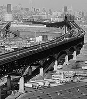
The Newark and New York Railroad Bridge, part of Central Railroad of New Jersey
Central Railroad of New Jersey
The Central Railroad of New Jersey , commonly known as the Jersey Central Lines or CNJ, was a Class I railroad with origins in the 1830s, lasting until 1976 when it was absorbed into Conrail with the other bankrupt railroads of the Northeastern United States...
, The Newark Plank Road
Newark Plank Road
The Newark Plank Road was a major 19th century artery between New Jersey's Hudson Waterfront and the burgeoning city of Newark, further inland across the New Jersey Meadows. As its name suggests, a plank road was constructed of wooden planks laid side-to-side on a roadbed. A charter to construct...
, and the Morris Canal
Morris Canal
The Morris Canal was an anthracite-carrying canal that incorporated a series of water-driven inclined planes in its course across northern New Jersey in the United States. It was in use for about a century — from the late 1820s to the 1920s....
all crossed the point running parallel to each other. Currently, both the Lincoln Highway
Lincoln Highway
The Lincoln Highway was the first road across the United States of America.Conceived and promoted by entrepreneur Carl G. Fisher, the Lincoln Highway spanned coast-to-coast from Times Square in New York City to Lincoln Park in San Francisco, originally through 13 states: New York, New Jersey,...
and The Pulaski Skyway
Pulaski Skyway
The General Pulaski Skyway is a four-lane freeway composed of connected bridges in the northeastern part of the U.S. state of New Jersey, carrying the designation of U.S. Route 1/9 for most of its length. The landmark structure has a total length of with the longest bridge spanning...
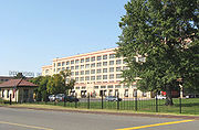
traverse South Kearny, a ramp of the latter built specifically to spur industrial development Among the many facilities that are located there are the Hudson County Correctional Center and River Terminal, a massive distribution warehouse that includes the former site of a Western Electric
Western Electric
Western Electric Company was an American electrical engineering company, the manufacturing arm of AT&T from 1881 to 1995. It was the scene of a number of technological innovations and also some seminal developments in industrial management...
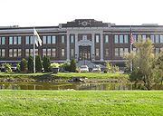
's Kearny Works manufacturing plant and the Kearny Yard of Federal Shipbuilding and Drydock Company
Federal Shipbuilding and Drydock Company
The Federal Shipbuilding and Drydock Company was a United States shipyard, active from 1917 to 1949. During World War II, it built ships as part of the U.S. Government's Emergency Shipbuilding Program. Operated by a subsidiary of the United States Steel Corporation, the shipyard was located at...
.
Transportation
 Hudson County Route 659 runs along Central Avenue, Pennsylvania Aveue, and Fish House Road. New Jersey Transit bus routes #1 and #80 serve the area.