
Sour Lake, Texas
Encyclopedia
Texas
Texas is the second largest U.S. state by both area and population, and the largest state by area in the contiguous United States.The name, based on the Caddo word "Tejas" meaning "friends" or "allies", was applied by the Spanish to the Caddo themselves and to the region of their settlement in...
, United States
United States
The United States of America is a federal constitutional republic comprising fifty states and a federal district...
. The population was 1,813 at the 2010 census. It was originally named Sour Lake Springs, after the mineral-laden spring water that flowed into the nearby lake. The city is part of the Beaumont
Beaumont, Texas
Beaumont is a city in and county seat of Jefferson County, Texas, United States, within the Beaumont–Port Arthur Metropolitan Statistical Area. The city's population was 118,296 at the 2010 census. With Port Arthur and Orange, it forms the Golden Triangle, a major industrial area on the...
–Port Arthur
Port Arthur, Texas
-Demographics:As of the 2000 census, there were 57,755 people, 21,839 households, and 14,675 families residing in the city. The population density was 696.5 people per square mile . There were 24,713 housing units at an average density of 298.0 per square mile...
Metropolitan Statistical Area
Beaumont–Port Arthur metropolitan area
The Beaumont–Port Arthur Metropolitan Area is defined by the United States Census Bureau as a three-county region in Southeast Texas, east of the Houston–Sugar Land–Baytown metropolitan area. The area is also known as the Golden Triangle...
. Sam Houston visited the "
Sour Lake" in his later years. The town is also home to one of the biggest sinkholes in Texas.
Sour Lake is the oldest surviving town in Hardin County. Sour Lake was first settled around 1835 when the Mexican State of Coahuilla y Tejas granted Stephen Jackson one league of land covering 4428 acres (17.9 km²) by Land Grant. It is called by some the "Gateway to the Big Thicket
Big Thicket
The Big Thicket is the name of a heavily forested area in Southeast Texas. While no exact boundaries exist, the area occupies much of Hardin County, Liberty, Tyler, San Jacinto, and Polk Counties and is roughly bounded by the San Jacinto River, Neches River, and Pine Island Bayou. To the north, it...
".
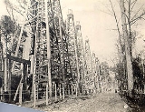
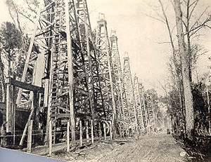
Sour Lake became a short-lived boomtown with the discovery of oil in 1901, shortly after oil was found at the nearby Spindletop
Spindletop
Spindletop is a salt dome oil field located in the southern portion of Beaumont, Texas in the United States. The Spindletop dome was derived from the Louann Salt evaporite layer of the Jurassic geologic period. On January 10, 1901, a well at Spindletop struck oil . The new oil field soon produced...
salt dome
Salt dome
A salt dome is a type of structural dome formed when a thick bed of evaporite minerals found at depth intrudes vertically into surrounding rock strata, forming a diapir....
. It is known as the birthplace of Texaco
Texaco
Texaco is the name of an American oil retail brand. Its flagship product is its fuel "Texaco with Techron". It also owns the Havoline motor oil brand....
. Formed in 1903, the Texas Company (Texaco's corporate name) is one of the three major oil companies that can trace its origins to the oil fields around Southeast Texas
Southeast Texas
Southeast Texas is a subregion of East Texas located in the southeast corner of the U.S. state of Texas. The subregion is geographically centered around the Houston–Sugar Land–Baytown and Beaumont–Port Arthur metropolitan areas...
. The Sour Lake oilfield produced about 90000000 barrels (14,308,856,550 l) of oil up to 1948, when it was producing about 3500 barrels (556,455.5 l) daily and new drilling was still underway. Today the Sour Lake oilfield is the oldest continuously-producing oil field in the world.
Geography
Sour Lake is located at 30°8′13"N 94°24′27"W (30.136950, -94.407387).According to the United States Census Bureau
United States Census Bureau
The United States Census Bureau is the government agency that is responsible for the United States Census. It also gathers other national demographic and economic data...
, the city has a total area of 1.7 square miles (4.4 km²), of which, 1.7 square miles (4.4 km²) of it is land and 0.57% is water.
Demographics
As of the censusCensus
A census is the procedure of systematically acquiring and recording information about the members of a given population. It is a regularly occurring and official count of a particular population. The term is used mostly in connection with national population and housing censuses; other common...
of 2000, there were 1,667 people, 672 households, and 446 families residing in the city. The population density
Population density
Population density is a measurement of population per unit area or unit volume. It is frequently applied to living organisms, and particularly to humans...
was 964.0 people per square mile (372.0/km²). There were 752 housing units at an average density of 434.9 per square mile (167.8/km²). The racial makeup of the city was 94.36% White, 3.18% African American, 0.36% Native American, 0.42% Asian, 0.42% from other races
Race (United States Census)
Race and ethnicity in the United States Census, as defined by the Federal Office of Management and Budget and the United States Census Bureau, are self-identification data items in which residents choose the race or races with which they most closely identify, and indicate whether or not they are...
, and 1.26% from two or more races. Hispanic or Latino of any race were 3.00% of the population.
There were 672 households out of which 31.4% had children under the age of 18 living with them, 52.8% were married couples
Marriage
Marriage is a social union or legal contract between people that creates kinship. It is an institution in which interpersonal relationships, usually intimate and sexual, are acknowledged in a variety of ways, depending on the culture or subculture in which it is found...
living together, 9.7% had a female householder with no husband present, and 33.6% were non-families. 31.4% of all households were made up of individuals and 17.9% had someone living alone who was 65 years of age or older. The average household size was 2.48 and the average family size was 3.15.
In the city the population was spread out with 27.5% under the age of 18, 6.8% from 18 to 24, 27.4% from 25 to 44, 21.9% from 45 to 64, and 16.5% who were 65 years of age or older. The median age was 38 years. For every 100 females there were 92.7 males. For every 100 females age 18 and over, there were 88.0 males.
The median income for a household in the city was $30,300, and the median income for a family was $39,605. Males had a median income of $36,406 versus $24,500 for females. The per capita income
Per capita income
Per capita income or income per person is a measure of mean income within an economic aggregate, such as a country or city. It is calculated by taking a measure of all sources of income in the aggregate and dividing it by the total population...
for the city was $15,497. About 8.5% of families and 12.7% of the population were below the poverty line, including 14.1% of those under age 18 and 15.6% of those age 65 or over.
Education
The City of Sour Lake is served by the Hardin-Jefferson Independent School DistrictHardin-Jefferson Independent School District
Hardin-Jefferson Independent School District is a public school district based in Sour Lake, Texas . The district covers south central Hardin and northwestern Jefferson counties....
.