

Sir Lowry's Pass
Encyclopedia

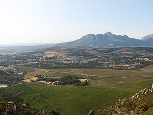
Mountain pass
A mountain pass is a route through a mountain range or over a ridge. If following the lowest possible route, a pass is locally the highest point on that route...
on the N2
N2 (South Africa)
The N2 is a National Route in South Africa; it is the main highway along the Indian Ocean coast of the country. The N2 starts in Cape Town in the Western Cape and runs through the cities of Port Elizabeth and East London in the Eastern Cape and Durban in KwaZulu-Natal to end at Ermelo in...
national road in the Western Cape
Western Cape
The Western Cape is a province in the south west of South Africa. The capital is Cape Town. Prior to 1994, the region that now forms the Western Cape was part of the much larger Cape Province...
province of South Africa
South Africa
The Republic of South Africa is a country in southern Africa. Located at the southern tip of Africa, it is divided into nine provinces, with of coastline on the Atlantic and Indian oceans...
. It crosses the Hottentots-Holland
Hottentots-Holland
The Hottentots Holland mountain range is part of the Cape Fold Belt in the Western Cape, South Africa. The range forms a barrier between the Cape Town metropolitan area and the southern Overberg coast. The range is primarily composed of Table Mountain Sandstone and forms an impressive range to the...
mountain range between Somerset West and Grabouw
Grabouw
Grabouw is a mid-sized town located in the Western Cape province of South Africa some 65 km south-east of Cape Town along the N2 highway. It is located over Sir Lowry's Pass from Somerset West in the Elgin Valley, which is sandwiched between the Hottentots-Holland, Kogelberg and Groenland...
on the main national road between Cape Town
Cape Town
Cape Town is the second-most populous city in South Africa, and the provincial capital and primate city of the Western Cape. As the seat of the National Parliament, it is also the legislative capital of the country. It forms part of the City of Cape Town metropolitan municipality...
and the Garden Route
Garden Route
The Garden Route is a popular stretch of the south-eastern coast of South Africa. It stretches from Heidelberg in the Western Cape to the Storms River which is crossed along the N2 coastal highway over the Paul Sauer Bridge in the extreme western reach of the neighbouring Eastern Cape...
. A railway line also crosses the mountain range at this point.
The pass is 4 lanes wide and is subject to heavy traffic, especially at the start and end of holiday periods when many people travel in and out of the Cape Town area, and is sometimes seen as an accident black spot.
The summit of the pass is at 420m. There is a viewpoint at the summit and this point is also used as a paragliding
Paragliding
Paragliding is the recreational and competitive adventure sport of flying paragliders: lightweight, free-flying, foot-launched glider aircraft with no rigid primary structure...
launch point. Baboons
Chacma Baboon
The Chacma baboon , also known as the Cape baboon, is, like all other baboons, from the Old World monkey family. With a body length of up to 115 cm and a weight from 15 to 31 kg, it is among the largest and heaviest baboon species. The Chacma is generally dark brown to gray in color,...
are often seen in this area. The top of the pass was formerly the start of the Boland Hiking Trail, but this section of the trail was closed after a number of deaths due to the difficult hiking conditions. On the Grabouw side, the road passes the Steenbras Dam
Steenbras Dam
The Steenbras Dam is a dam in the Hottentots-Holland mountains near Cape Town in South Africa. It is one of the city's water supplies. The Steenbras pumped-storage scheme was opened in 1979 to supplement the city's electricity supply during peak demand periods....
.
Sir Lowry's Pass Village
Sir Lowry's Pass Village
Sir Lowry's Pass Village is a town near the base of Sir Lowry's Pass, about 60 km from Cape Town, South Africa....
is situated near the base of the pass.
History
The mountain crossing in that region was known by the indigenous KhoiKhoi
Khoi may refer to:*The common name of Siamese Rough Bush, Streblus asper Lour*The Khoikhoi people*One of the Khoe languages*The Khoekhoe language*Khoy, a city in Iran*Khoy County, an administrative subdivision of Iran...
people as the Gantouw or Eland
Common Eland
The common eland , also known as the southern eland or eland antelope, is a savannah and plains antelope found in East and Southern Africa. It is the largest antelope in the African continent...
's Pass, and was used as a stock route. The Dutch and British settlers at the Cape built a rough pass called the Hottentots Holland Kloof Pass following the Gantouw route. The first recorded crossing was in 1664, and by 1821 the pass was seeing 4500 ox-wagon
Ox-wagon
An ox-wagon or bullock wagon is a four-wheeled vehicle pulled by oxen . It was a traditional form of transport, especially in Southern Africa but also in New Zealand and Australia. Ox-wagons were also used in the United States...
s per year crossing into the interior, but the route was so severe that more than 20% of them were damaged. The ruts left by these wagons being dragged over the mountains can still be seen, and were declared a National Monument in 1958.
Starting in 1828, a new pass was constructed on the current route, about 2 km to the south of the Hottentots Holland Kloof, by the engineer Charles Michell
Charles Collier Michell
Lieutenant-Colonel Charles Collier Michell, , later known as Charles Cornwallis Michell, was a British soldier, first surveyor-general in the Cape, road engineer, architect, artist and naturalist.-Early life:...
using convict labour. The new pass was opened on 6 July 1830, and named after Lowry Cole, the Governor of the Cape Colony
Cape Colony
The Cape Colony, part of modern South Africa, was established by the Dutch East India Company in 1652, with the founding of Cape Town. It was subsequently occupied by the British in 1795 when the Netherlands were occupied by revolutionary France, so that the French revolutionaries could not take...
at the time. In the 1930s, the pass was widened and tarred; it was further improved in the 1950s, and in 1984 the upper parts were widened to four lanes in a reinforced concrete construction.