
Simpson Desert National Park
Encyclopedia
National park
A national park is a reserve of natural, semi-natural, or developed land that a sovereign state declares or owns. Although individual nations designate their own national parks differently A national park is a reserve of natural, semi-natural, or developed land that a sovereign state declares or...
in Queensland
Queensland
Queensland is a state of Australia, occupying the north-eastern section of the mainland continent. It is bordered by the Northern Territory, South Australia and New South Wales to the west, south-west and south respectively. To the east, Queensland is bordered by the Coral Sea and Pacific Ocean...
, Australia
Australia
Australia , officially the Commonwealth of Australia, is a country in the Southern Hemisphere comprising the mainland of the Australian continent, the island of Tasmania, and numerous smaller islands in the Indian and Pacific Oceans. It is the world's sixth-largest country by total area...
, 1495 km west of Brisbane. The park covers an area of more than 10,00 km² in the Simpson Desert
Simpson Desert
The Simpson Desert is a large area of dry, red sandy plain and dunes in Northern Territory, South Australia and Queensland in central Australia. It is the fourth largest Australian desert, with an area of 176,500 km² ....
surrounding Poeppel Corner west of Birdsville
Birdsville, Queensland
-External links:*...
and Bedourie
Bedourie, Queensland
Bedourie is a small town located in the Channel Country of western Queensland, Australia, lying on Eyre Creek. It is located 1600 kilometres west of the state capital, Brisbane, and 200 kilometres north of Birdsville. At the 2006 census, Bedourie and the surrounding area had a population of 142...
in the southwest of the state.
Landforms
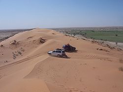
The main features of the park are large sand dunes which can be 50 m high and around 1 km apart. Most dunes are between 10 and 35 m in height. The longest sand ridge is 200 km in length. One of the most prominent dunes is called 'Big Red' and is located 35 km west of Birdsville. The dunes started to form 30,000 years ago. Also found in the park are salt lakeSalt lake
A salt lake or saline lake is a landlocked body of water which has a concentration of salts and other dissolved minerals significantly higher than most lakes . In some cases, salt lakes have a higher concentration of salt than sea water, but such lakes would also be termed hypersaline lakes...
s and claypan
Claypan
In geology, a claypan is a dense, compact, slowly permeable layer in the subsoil having a much higher clay content than the overlying material, from which it is separated by a sharply defined boundary. Claypans are usually hard when dry, and plastic and sticky when wet. They limit or slow the...
s.
Flora and fauna
The landscape supports up to 180 bird species. Other animals which may be seen include the dingoDingo
The Australian Dingo or Warrigal is a free-roaming wild dog unique to the continent of Australia, mainly found in the outback. Its original ancestors are thought to have arrived with humans from southeast Asia thousands of years ago, when dogs were still relatively undomesticated and closer to...
, gecko
Gecko
Geckos are lizards belonging to the infraorder Gekkota, found in warm climates throughout the world. They range from 1.6 cm to 60 cm....
s and the feral camel. With the falling of any significant rains comes a transformation of dormant wildflowers.
Tourism
Visitors are encouraged to visit from April to October to avoid extreme daytime temperatures and to travel within a two-vehicle party with long distance communications equipment. A 4WD vehicle is needed to travel through the park. There are no roads in the park. The main track is called the QAA Line. Winter mornings can be freezing, while summer temperatures can be as hot as 50°. Camping is permitted within 500 m of the QAA Line. Vehicles are not permitted to leave the main track.Park rangers who are based at Birdsville occasionally close the park when flooded rivers pose a risk to tourists. Increasing tourist numbers have been depleting wood supplies to the point that native fauna could be affected. This has led to authorities encouraging the use of gas camp stove
Stove
A stove is an enclosed heated space. The term is commonly taken to mean an enclosed space in which fuel is burned to provide heating, either to heat the space in which the stove is situated or to heat the stove itself, and items placed on it...
s.
History
Aboriginals have lived in the region for generations. They survived in the dry conditions by digging soaks in the depressions between dunes, some of which were 7m deep.David Lindsay
David Lindsay (explorer)
David Lindsay was an Australian explorer and surveyor and a fellow of the Royal Geographical Society, London.-Early life:...
was the first non-Aboriginal person to cross the central and southern areas of the Simpson Desert in 1886. It wasn't until 1936 that Ted Colson crossed the full length of the desert.
A national park in the desert was first suggested in 1965 by the National Parks Association. The park was extended northwards in 1991. The expansion included arid lands with a more diverse range of vegetation.
See also
- Simpson Desert Conservation ParkSimpson Desert Conservation ParkSimpson Desert Regional Reserve is located in South Australia, north of Port Augusta. In combination with Simpson Desert Regional Reserve and Witjira National Park, it forms a protected area representing one of the world's best examples of dunal desert...
- Simpson Desert Important Bird AreaSimpson Desert Important Bird AreaThe Simpson Desert Important Bird Area comprises some 22,848 km2 of land in the Simpson Desert region of south-western Queensland and north-eastern South Australia...
- Simpson Desert Regional ReserveSimpson Desert Regional Reserve-See also:*Simpson Desert*Simpson Desert Conservation Park*Simpson Desert Important Bird Area*Simpson Desert National Park-External links:* - Department for Environment and Heritage...
- Protected areas of QueenslandProtected areas of QueenslandQueensland is the second largest state in Australia. It contains 470 separate Protected Areas with a total land area of 69,388 km² . 223 of these are National parks, which is the highest number of any Australian state or territory, totalling 65,871 km²...