
Shire of Woodanilling
Encyclopedia
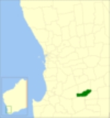
The Shire of Woodanilling is a Local Government Area
in the Great Southern region of Western Australia
, about 30 kilometres (19 mi) south of Wagin
and about 260 kilometres (162 mi) south-southeast of the state capital, Perth
. The Shire covers an area of 1129 square kilometres (436 sq mi), and its seat of government is the town of Woodanilling
.
Local Government Areas of Western Australia
The Australian state of Western Australia is divided into 141 local government areas...
in the Great Southern region of Western Australia
Western Australia
Western Australia is a state of Australia, occupying the entire western third of the Australian continent. It is bounded by the Indian Ocean to the north and west, the Great Australian Bight and Indian Ocean to the south, the Northern Territory to the north-east and South Australia to the south-east...
, about 30 kilometres (19 mi) south of Wagin
Wagin, Western Australia
Wagin is a town and shire in the Great Southern region of Western Australia, approximately 225 km south-east of Perth on the Great Southern Highway between Narrogin and Katanning. It is also on State Route 107. The main industries are wheat and sheep farming.-History:The name of the town is...
and about 260 kilometres (162 mi) south-southeast of the state capital, Perth
Perth, Western Australia
Perth is the capital and largest city of the Australian state of Western Australia and the fourth most populous city in Australia. The Perth metropolitan area has an estimated population of almost 1,700,000....
. The Shire covers an area of 1129 square kilometres (436 sq mi), and its seat of government is the town of Woodanilling
Woodanilling, Western Australia
Woodanilling is a small town in the Great Southern region of Western Australia, 254 km south of Perth on the Great Southern Highway, 24 km from Katanning and 30 km from Wagin....
.
History
The Woodanilling Road District was created in 1906. On 1 July 1961, it became a Shire under the Local Government Act 1960.Wards
The shire is divided into 3 wards:- Central Ward (2 councillors)
- West Ward (3 councillors)
- East Ward (2 councillors)
Towns and localities
- WoodanillingWoodanilling, Western AustraliaWoodanilling is a small town in the Great Southern region of Western Australia, 254 km south of Perth on the Great Southern Highway, 24 km from Katanning and 30 km from Wagin....
- Beaufort River
- Cartmeticup
Population
| Year | Population |
|---|---|
| 1911 | 614 |
| 1921 | 639 |
| 1933 | 671 |
| 1947 | 697 |
| 1954 | 718 |
| 1961 | 639 |
| 1966 | 580 |
| 1971 | 529 |
| 1976 | 447 |
| 1981 | 461 |
| 1986 | 435 |
| 1991 | 391 |
| 1996 | 354 |
| 2001 | 394 |
| 2006 | 418 |
| 2009 | 452 |