
Shire of Westonia
Encyclopedia
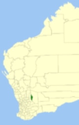
The Shire of Westonia is a Local Government Area
in the Eastern Wheatbelt region of Western Australia
, about 310 kilometres (193 mi) east of Perth
, the state capital. Its seat of government is the small town of Westonia
.
Although the Shire of Westonia is located in the Wheatbelt region, it is at the eastern limit of land suitable for wheat
growing. The most important industries of Westonia today are wheat and sheep, but historically it is a gold mining
area.
As a result of local government reforms in Western Australia, the Shire of Westonia will merge with the Shire of Yilgarn in July 2012, forming the Shire of Westonia-Yilgarn.
Local Government Areas of Western Australia
The Australian state of Western Australia is divided into 141 local government areas...
in the Eastern Wheatbelt region of Western Australia
Western Australia
Western Australia is a state of Australia, occupying the entire western third of the Australian continent. It is bounded by the Indian Ocean to the north and west, the Great Australian Bight and Indian Ocean to the south, the Northern Territory to the north-east and South Australia to the south-east...
, about 310 kilometres (193 mi) east of Perth
Perth, Western Australia
Perth is the capital and largest city of the Australian state of Western Australia and the fourth most populous city in Australia. The Perth metropolitan area has an estimated population of almost 1,700,000....
, the state capital. Its seat of government is the small town of Westonia
Westonia, Western Australia
Westonia is a small town located in the Eastern Wheatbelt region of Western Australia, 10 kilometres north of the Great Eastern Highway. It is the main town in the Shire of Westonia.-History:...
.
Although the Shire of Westonia is located in the Wheatbelt region, it is at the eastern limit of land suitable for wheat
Wheat
Wheat is a cereal grain, originally from the Levant region of the Near East, but now cultivated worldwide. In 2007 world production of wheat was 607 million tons, making it the third most-produced cereal after maize and rice...
growing. The most important industries of Westonia today are wheat and sheep, but historically it is a gold mining
Gold mining
Gold mining is the removal of gold from the ground. There are several techniques and processes by which gold may be extracted from the earth.-History:...
area.
History
In 1916, the Westonia Road District was created on land previously within Merredin Road District. On 1 July 1961, it became the Shire of Westonia under the Local Government Act 1960.As a result of local government reforms in Western Australia, the Shire of Westonia will merge with the Shire of Yilgarn in July 2012, forming the Shire of Westonia-Yilgarn.
Wards
The shire initially had a ward system with two elected members representing the north, south, west and town wards (for a total of eight members). However, following the 2009 local government elections the Shire of Westonia's ward system was abolished and the number of elected members was dropped to six.Towns
- WestoniaWestonia, Western AustraliaWestonia is a small town located in the Eastern Wheatbelt region of Western Australia, 10 kilometres north of the Great Eastern Highway. It is the main town in the Shire of Westonia.-History:...
- Boodarockin
- CarrabinCarrabin, Western AustraliaCarrabin is a small town located about east-northeast of Merredin, on the railway line between Merredin and Southern Cross in Western Australia....
- WalgoolanWalgoolan, Western AustraliaWalgoolan is a small town located in the Eastern Wheatbelt region of Western Australia. It is situated between Merredin and Bodallin along the Great Eastern Highway....
- Warrachuppin
- Warralakin
Population
| Year | Population |
|---|---|
| 1921 | 842 |
| 1933 | 1,032 |
| 1947 | 547 |
| 1954 | 487 |
| 1961 | 435 |
| 1966 | 612 |
| 1971 | 473 |
| 1976 | 510 |
| 1981 | 453 |
| 1986 | 484 |
| 1991 | 282 |
| 1996 | 292 |
| 2001 | 237 |
| 2006 | 213 |