
Shire of Wagin
Encyclopedia
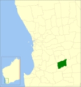
The Shire of Wagin is a Local Government Area
in the Wheatbelt region of Western Australia
, about 230 kilometres (143 mi) southeast of the state capital, Perth
. The Shire covers an area of about 1948 square kilometres (752 sq mi), and its seat of government is the town of Wagin
.
On 1 July 1961, it became a Shire under the Local Government Act 1960.
Local Government Areas of Western Australia
The Australian state of Western Australia is divided into 141 local government areas...
in the Wheatbelt region of Western Australia
Western Australia
Western Australia is a state of Australia, occupying the entire western third of the Australian continent. It is bounded by the Indian Ocean to the north and west, the Great Australian Bight and Indian Ocean to the south, the Northern Territory to the north-east and South Australia to the south-east...
, about 230 kilometres (143 mi) southeast of the state capital, Perth
Perth, Western Australia
Perth is the capital and largest city of the Australian state of Western Australia and the fourth most populous city in Australia. The Perth metropolitan area has an estimated population of almost 1,700,000....
. The Shire covers an area of about 1948 square kilometres (752 sq mi), and its seat of government is the town of Wagin
Wagin, Western Australia
Wagin is a town and shire in the Great Southern region of Western Australia, approximately 225 km south-east of Perth on the Great Southern Highway between Narrogin and Katanning. It is also on State Route 107. The main industries are wheat and sheep farming.-History:The name of the town is...
.
History
The Arthur Road District was created in 1887, and was renamed Wagin in 1905. In July 1906, a separate Municipality of Wagin was created to serve the town, while the Road District continued to serve the surrounding area. In 1961, the Municipality was abolished, and a new Town Ward was created within the district.On 1 July 1961, it became a Shire under the Local Government Act 1960.
Wards
The shire was divided into wards until 1991, but wards were abolished and councillors now sit at large. There are at present 11 councillors.Towns and localities
- WaginWagin, Western AustraliaWagin is a town and shire in the Great Southern region of Western Australia, approximately 225 km south-east of Perth on the Great Southern Highway between Narrogin and Katanning. It is also on State Route 107. The main industries are wheat and sheep farming.-History:The name of the town is...
- Ballaying
- Cancanning
- Collanilling
- Jaloran
- PiessevillePiesseville, Western AustraliaPiesseville is a small town in the Wheatbelt region of Western Australia, south-east of Perth on the Great Southern Highway between Narrogin and Wagin. It is also on the Great Southern Railway...
- Wedgecarrup