
Shire of Toodyay
Encyclopedia
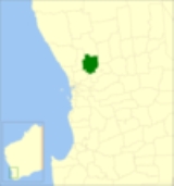
The Shire of Toodyay is a Local Government Area
in the Wheatbelt region of Western Australia
, beyond the north-eastern limits of the Perth
metropolitan area. The Shire covers an area of 1694 square kilometres (654 sq mi), and its seat of government is the town of Toodyay
.
Local Government Areas of Western Australia
The Australian state of Western Australia is divided into 141 local government areas...
in the Wheatbelt region of Western Australia
Western Australia
Western Australia is a state of Australia, occupying the entire western third of the Australian continent. It is bounded by the Indian Ocean to the north and west, the Great Australian Bight and Indian Ocean to the south, the Northern Territory to the north-east and South Australia to the south-east...
, beyond the north-eastern limits of the Perth
Perth, Western Australia
Perth is the capital and largest city of the Australian state of Western Australia and the fourth most populous city in Australia. The Perth metropolitan area has an estimated population of almost 1,700,000....
metropolitan area. The Shire covers an area of 1694 square kilometres (654 sq mi), and its seat of government is the town of Toodyay
Toodyay, Western Australia
Toodyay is a town located in the Wheatbelt region in the Avon Valley, 85 km north-east of Perth, Western Australia. Toodyay is connected to Perth via both rail and road.-History:...
.
History
In 1871, the Toodyay Road Board was gazetted, and in 1877, the Newcastle Municipal Council followed. The latter was abolished and merged in 1912, shortly after the town's move, and on 1 July 1961, it became the Shire Council following changes to the Local Government Act.Wards
The shire has been divided into 4 wards.- North Ward
- Central Ward
- West Ward (3 councillors)
- East Ward (2 councillors)
Towns and localities
- ToodyayToodyay, Western AustraliaToodyay is a town located in the Wheatbelt region in the Avon Valley, 85 km north-east of Perth, Western Australia. Toodyay is connected to Perth via both rail and road.-History:...
- BailupBailup, Western AustraliaBailup is a Western Australian locality and rural residential estate located north-east of the state capital, Perth, along Toodyay Road. The area is split between the Shire of Toodyay and Shire of Mundaring, the latter of which contains most of the land area....
- BejoordingBejoording, Western AustraliaBejoording is a small town in the Wheatbelt region of Western Australia.The first European to visit the area was George Fletcher Moore who explored the area in 1836. Moore recorded the Aboriginal name of the area as Bejoording....
- Culham
- Dewars Pool
- Dumbarton
- Julimar
- Morangup
- Hoddys Well
- West Toodyay