
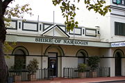
Shire of Narrogin
Encyclopedia
Local Government Areas of Western Australia
The Australian state of Western Australia is divided into 141 local government areas...
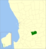
in the Wheatbelt region of Western Australia
Western Australia
Western Australia is a state of Australia, occupying the entire western third of the Australian continent. It is bounded by the Indian Ocean to the north and west, the Great Australian Bight and Indian Ocean to the south, the Northern Territory to the north-east and South Australia to the south-east...
, about 190 kilometres (118 mi) south-east of the state capital, Perth
Perth, Western Australia
Perth is the capital and largest city of the Australian state of Western Australia and the fourth most populous city in Australia. The Perth metropolitan area has an estimated population of almost 1,700,000....
. Curiously, the town of Narrogin
Narrogin, Western Australia
Narrogin is a large town in the Wheatbelt region of Western Australia, southeast of Perth on the Great Southern Highway between Pingelly and Wagin...
serves as the Shire's seat of government, despite the fact that it is not part of the shire itself. The Shire covers an area of 1619 square kilometres (625 sq mi) and has a population of 846 (ABS 2001).
| Pages associated with Narrogin, Western Australia Narrogin, Western Australia Narrogin is a large town in the Wheatbelt region of Western Australia, southeast of Perth on the Great Southern Highway between Pingelly and Wagin... |
|---|
|
History
In 1892, the Narrogin Road District came into being. On 1 July 1961, it became a Shire under the Local Government Act 1960. In 1999 and 2004, proposals to merge the Shire with the Town of NarroginTown of Narrogin
The Town of Narrogin is a Local Government Area of Western Australia for the town of Narrogin in the Wheatbelt region of Western Australia, south-east of the capital, Perth along Great Southern Highway. The Shire has a population of 4,238 ....
were defeated at referendum
Referendum
A referendum is a direct vote in which an entire electorate is asked to either accept or reject a particular proposal. This may result in the adoption of a new constitution, a constitutional amendment, a law, the recall of an elected official or simply a specific government policy. It is a form of...
.
Wards
The shire had 4 wards until the 2005 election, but they have since been abolished. 7 councillors sit at large.Towns and localities
- Boundain
- HighburyHighbury, Western AustraliaHighbury is a small town in the Wheatbelt region of Western Australia, located along the Great Southern Highway between Narrogin and Wagin. At the 2006 census, Highbury had a population of 493.-History:...
- Nomans Lake
- YilliminningYilliminning, Western AustraliaYilliminning is a small town located in the southern Wheatbelt region of Western Australia, southeast of the state capital, Perth and 20 kilometres east of Narrogin. At the 2006 census, Yilliminning had a population of 337.-History:...
Population
| Year | Population |
|---|---|
| 1911 | 889 |
| 1921 | 1,117 |
| 1933 | 1,217 |
| 1947 | 844 |
| 1954 | 966 |
| 1961 | 972 |
| 1966 | 1,010 |
| 1971 | 905 |
| 1976 | 843 |
| 1981 | 813 |
| 1986 | 680 |
| 1991 | 862 |
| 1996 | 867 |
| 2001 | 843 |
| 2006 | 830 |