
Shire of Huntly
Encyclopedia
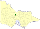
The Shire of Huntly was a Local Government Area located immediately to the northeast of the regional city of Bendigo
, Victoria
, Australia
. The shire covered an area of 878 square kilometres (339 sq mi), and existed from 1861 until 1994.
On 7 April 1994, the Shire was abolished—one of the first to disappear under the Kennett
Liberal
government's statewide local government restructuring program—and merged with the City of Bendigo
, the Borough of Eaglehawk
, the Shire of Strathfieldsaye
and the Rural City of Marong
to form the City of Greater Bendigo
.

* Estimate in the 1958 Victorian Year Book.
Bendigo, Victoria
Bendigo is a major regional city in the state of Victoria, Australia, located very close to the geographical centre of the state and approximately north west of the state capital Melbourne. It is the second largest inland city and fourth most populous city in the state. The estimated urban...
, Victoria
Victoria (Australia)
Victoria is the second most populous state in Australia. Geographically the smallest mainland state, Victoria is bordered by New South Wales, South Australia, and Tasmania on Boundary Islet to the north, west and south respectively....
, Australia
Australia
Australia , officially the Commonwealth of Australia, is a country in the Southern Hemisphere comprising the mainland of the Australian continent, the island of Tasmania, and numerous smaller islands in the Indian and Pacific Oceans. It is the world's sixth-largest country by total area...
. The shire covered an area of 878 square kilometres (339 sq mi), and existed from 1861 until 1994.
History
The need for a council at Huntly arose from gold and quartz mining in the area, including alluvial deposits and some deep leads in the area. Huntly was first incorporated as a district on 10 March 1861, and became a shire on 13 July 1866. From 1867 until 1977, councillors met at the Council Chambers at 620-634 Midland Highway, Huntly, but subsequently they moved into a new location.On 7 April 1994, the Shire was abolished—one of the first to disappear under the Kennett
Jeff Kennett
Jeffrey Gibb Kennett AC , a former Australian politician, was the Premier of Victoria between 1992 and 1999. He is currently the President of Hawthorn Football Club. He is the founding Chairman of beyondblue, a national depression initiative.- Early life :Kennett was born in Melbourne on 2 March...
Liberal
Liberal Party of Australia
The Liberal Party of Australia is an Australian political party.Founded a year after the 1943 federal election to replace the United Australia Party, the centre-right Liberal Party typically competes with the centre-left Australian Labor Party for political office...
government's statewide local government restructuring program—and merged with the City of Bendigo
City of Bendigo
The City of Bendigo was a Local Government Area which covered the central area and inner western suburbs of the regional city of Bendigo, Victoria, Australia...
, the Borough of Eaglehawk
Borough of Eaglehawk
The Borough of Eaglehawk was a Local Government Area which covered the northwestern suburbs of the regional city of Bendigo, Victoria, Australia. The borough covered an area of , and existed from 1862 until 1994....
, the Shire of Strathfieldsaye
Shire of Strathfieldsaye
The Shire of Strathfieldsaye was a Local Government Area located immediately to the east and southeast of the regional city of Bendigo, Victoria, Australia, and included the eastern suburbs of Bendigo's metropolitan area...
and the Rural City of Marong
Rural City of Marong
The Rural City of Marong was a Local Government Area located about north-northwest of Melbourne, the state capital of Victoria, Australia. The shire covered an area of , and existed from 1861 until 1994.-History:...
to form the City of Greater Bendigo
City of Greater Bendigo
The City of Greater Bendigo is a Local Government Area in Victoria, Australia. It is located in the central-western part of the state. It has an area of 3,048 square kilometres...
.
Wards
Huntly was divided into three wards, each of which elected three councillors:- North Ward
- South Ward
- West Ward
Towns and localities
|
|
Population
| Year | Population |
|---|---|
| 1954 | 2,247 |
| 1958 | 2,330* |
| 1961 | 2,295 |
| 1966 | 2,333 |
| 1971 | 2,242 |
| 1976 | 2,400 |
| 1981 | 3,043 |
| 1986 | 3,896 |
| 1991 | 4,542 |
* Estimate in the 1958 Victorian Year Book.