
Shire of Grenville
Encyclopedia
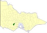
The Shire of Grenville was a Local Government Area located southwest of the regional city of Ballarat
, Victoria
, Australia
. The shire covered an area of 845 square kilometres (326.3 sq mi), and existed from 1861 until 1994.
On 6 May 1994, the Shire was abolished, and merged with Shire of Bannockburn
, Shire of Leigh
and part of Buninyong
into the Golden Plains Shire
.
* Estimate in 1958 Victorian Year Book.
Ballarat, Victoria
Ballarat is a city in the state of Victoria, Australia, approximately west-north-west of the state capital Melbourne situated on the lower plains of the Great Dividing Range and the Yarrowee River catchment. It is the largest inland centre and third most populous city in the state and the fifth...
, Victoria
Victoria (Australia)
Victoria is the second most populous state in Australia. Geographically the smallest mainland state, Victoria is bordered by New South Wales, South Australia, and Tasmania on Boundary Islet to the north, west and south respectively....
, Australia
Australia
Australia , officially the Commonwealth of Australia, is a country in the Southern Hemisphere comprising the mainland of the Australian continent, the island of Tasmania, and numerous smaller islands in the Indian and Pacific Oceans. It is the world's sixth-largest country by total area...
. The shire covered an area of 845 square kilometres (326.3 sq mi), and existed from 1861 until 1994.
History
Grenville was first incorporated as a district on 27 August 1861, and became a shire on 16 February 1864. On 1 October 1915, under the Local Government Amendment Act 1914, it absorbed the areas of two boroughs—Browns and Scarsdale, which had incorporated on 25 July 1862 with an area of 23.31 square kilometres (5,760 acre), and Smythesdale, incorporated on 12 April 1861 with an area of 5.83 square kilometres (1,441 acre).On 6 May 1994, the Shire was abolished, and merged with Shire of Bannockburn
Shire of Bannockburn
The Shire of Bannockburn was a Local Government Area located about west-southwest of Melbourne, the state capital of Victoria, Australia. The shire covered an area of , and existed from 1862 until 1994.-History:...
, Shire of Leigh
Shire of Leigh
The Shire of Leigh was a Local Government Area located about west of Melbourne, the state capital of Victoria, Australia. The shire covered an area of , and existed from 1861 until 1994.-History:...
and part of Buninyong
Shire of Buninyong
The Shire of Buninyong was a Local Government Area located south and southeast of the regional city of Ballarat, Victoria, Australia. The shire covered an area of , and existed from 1858 until 1994.-History:...
into the Golden Plains Shire
Golden Plains Shire
Golden Plains Shire is a Local Government Area in Victoria, Australia. It is located in the south-western part of the state. It includes the towns of Bannockburn, Gheringhap, Linton, Berringa and Meredith. It has an area of 2,721 square kilometres. In 2009 it had a population of 18,173...
.
Wards
Grenville was divided into four ridings on 16 May 1977, each of which elected three councillors:- Delacombe Riding
- East Riding
- North Riding
- West Riding
Towns and localities
- Bonshaw
- DelacombeDelacombe, VictoriaDelacombe is a large and rapidly growing industrial/residential suburb on the south west rural-urban fringe of Ballarat, Victoria, Australia. The population at the 2006 census was 3,811 making it the sixth most populated in the Ballarat urban area....
- HaddonHaddon, VictoriaHaddon is a town just a few kilometres west the city of Ballarat. It is in the Golden Plains Shire. The township only has a population a bit above 1,000 people. Its postcode is 3351....
- Happy Valley
- LintonLinton, VictoriaLinton is a town in Victoria, Australia off Glenelg Highway. It was first settled about 1840. The town was named after a pioneer family in an area. At the 2006 census, Linton had a population of 355. The Clarkesdale Bird Sanctuary lies to the south-east of the township, near Springdallah Creek.-...
- Nintingbool
- Piggoreet
- ScarsdaleScarsdale, VictoriaScarsdale a town close to Newtown, Victoria , Australia. It is a small town close to Ballarat....
- SmythesdaleSmythesdale, VictoriaSmythesdale is a town in Victoria, Australia. The town is located on the Glenelg Highway in the Golden Plains Shire Local Government Area, west of Ballarat and west of the state capital, Melbourne. At the 2006 census, Smythesdale had a population of 280....
- Smythes Creek
Population
| Year | Population |
|---|---|
| 1954 | 1,862 |
| 1958 | 1,910* |
| 1961 | 1,833 |
| 1966 | 1,692 |
| 1971 | 1,802 |
| 1976 | 2,790 |
| 1981 | 4,293 |
| 1986 | 6,395 |
| 1991 | 8,113 |
* Estimate in 1958 Victorian Year Book.