
Shire of Dumbleyung
Encyclopedia
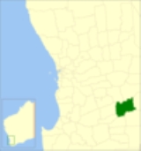
The Shire of Dumbleyung is a Local Government Area
located in the Wheatbelt region of Western Australia
, about 40 kilometres (25 mi) east of Wagin
and about 275 kilometres (171 mi) southeast of Perth
, the state capital. The Shire covers an area of 2540 square kilometres (981 sq mi), and is involved in grain and livestock production and various biodiversity industries including cereals, summer crops, oil mallees, yabbies, emus, poultry and trout. Its seat of government is the town of Dumbleyung
.
Previously, there were 5 wards: Central (Dumbleyung), North (Dongolocking), South (Datatine), Merilup and Kukerin.
Local Government Areas of Western Australia
The Australian state of Western Australia is divided into 141 local government areas...
located in the Wheatbelt region of Western Australia
Western Australia
Western Australia is a state of Australia, occupying the entire western third of the Australian continent. It is bounded by the Indian Ocean to the north and west, the Great Australian Bight and Indian Ocean to the south, the Northern Territory to the north-east and South Australia to the south-east...
, about 40 kilometres (25 mi) east of Wagin
Wagin, Western Australia
Wagin is a town and shire in the Great Southern region of Western Australia, approximately 225 km south-east of Perth on the Great Southern Highway between Narrogin and Katanning. It is also on State Route 107. The main industries are wheat and sheep farming.-History:The name of the town is...
and about 275 kilometres (171 mi) southeast of Perth
Perth, Western Australia
Perth is the capital and largest city of the Australian state of Western Australia and the fourth most populous city in Australia. The Perth metropolitan area has an estimated population of almost 1,700,000....
, the state capital. The Shire covers an area of 2540 square kilometres (981 sq mi), and is involved in grain and livestock production and various biodiversity industries including cereals, summer crops, oil mallees, yabbies, emus, poultry and trout. Its seat of government is the town of Dumbleyung
Dumbleyung, Western Australia
Dumbleyung is a town and shire in the Wheatbelt region of Western Australia, south-east of Perth between Wagin and Lake Grace on State Route 107.-History:...
.
History
On 1 October 1909, the Dumbleyung Road District was created. On 1 July 1961, it became a Shire following the enactment of the Local Government Act 1960.Wards
As of 3 May 2003, the shire has been divided into 4 wards.- Dumbleyung Ward (3 councillors)
- North Ward (3 councillors)
- Kukerin (1 councillor)
- South Ward (2 councillors)
Previously, there were 5 wards: Central (Dumbleyung), North (Dongolocking), South (Datatine), Merilup and Kukerin.
Towns
- DumbleyungDumbleyung, Western AustraliaDumbleyung is a town and shire in the Wheatbelt region of Western Australia, south-east of Perth between Wagin and Lake Grace on State Route 107.-History:...
- Dongolocking
- KukerinKukerin, Western AustraliaKukerin is a small town in the Wheatbelt region of Western Australia, south-east of Perth between Wagin and Lake Grace just off State Route 107. The town itself is small but services a considerable agricultural region in the eastern Shire of Dumbleyung...
- Merilup
- Moulyinning
- Nippering
- Tarin RockTarin Rock, Western AustraliaTarin Rock is a locality, railway siding and rock formation on the Wagin to Lake Grace branch line, located approx 18 km east of Kukerin in Western Australia....
Population
| Year | Population |
|---|---|
| 1911 | 929 |
| 1921 | 1,689 |
| 1933 | 1,610 |
| 1947 | 1,246 |
| 1954 | 1,493 |
| 1961 | 1,444 |
| 1966 | 1,458 |
| 1971 | 1,221 |
| 1976 | 1,038 |
| 1981 | 1,009 |
| 1986 | 1,021 |
| 1991 | 856 |
| 1996 | 834 |
| 2001 | 701 |
| 2006 | 632 |