
Shire of Cuballing
Encyclopedia
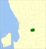
The Shire of Cuballing is a Local Government Area
located in the Wheatbelt region of Western Australia
, about 20 kilometres (12 mi) north of the town of Narrogin
and 175 kilometres (109 mi) southeast of the capital, Perth
. The Shire covers an area of 1195 square kilometres (461 sq mi) and its seat of government is the small town of Cuballing
.
Over 10% of its area contains native dryandra
forests. The economy, worth approximately $20 million per year to the state economy, is based on agriculture, with cereal grains, sheep and pig farming being the main activities
Between 1912 and 2003, the ward names were as follows:
Local Government Areas of Western Australia
The Australian state of Western Australia is divided into 141 local government areas...
located in the Wheatbelt region of Western Australia
Western Australia
Western Australia is a state of Australia, occupying the entire western third of the Australian continent. It is bounded by the Indian Ocean to the north and west, the Great Australian Bight and Indian Ocean to the south, the Northern Territory to the north-east and South Australia to the south-east...
, about 20 kilometres (12 mi) north of the town of Narrogin
Narrogin, Western Australia
Narrogin is a large town in the Wheatbelt region of Western Australia, southeast of Perth on the Great Southern Highway between Pingelly and Wagin...
and 175 kilometres (109 mi) southeast of the capital, Perth
Perth, Western Australia
Perth is the capital and largest city of the Australian state of Western Australia and the fourth most populous city in Australia. The Perth metropolitan area has an estimated population of almost 1,700,000....
. The Shire covers an area of 1195 square kilometres (461 sq mi) and its seat of government is the small town of Cuballing
Cuballing, Western Australia
Cuballing is a town located in the Wheatbelt region of Western Australia, on Great Southern Highway, between Pingelly and Narrogin. At the 2006 census, Cuballing had a population of 335.-History:...
.
Over 10% of its area contains native dryandra
Dryandra
Banksia ser. Dryandra is a series of 94 species of shrub to small tree in the plant genus Banksia. It was considered a separate genus named Dryandra until early 2007, when it was merged into Banksia on the basis of extensive molecular and morphological evidence that Banksia was paraphyletic with...
forests. The economy, worth approximately $20 million per year to the state economy, is based on agriculture, with cereal grains, sheep and pig farming being the main activities
History
On 31 October 1902, the Cuballing Road District was created. On 1 July 1961, it became a Shire following the enactment of the Local Government Act 1960.Wards
On 3 May 2003, the shire was divided into 2 wards.- North Ward (3 councillors)
- South Ward (4 councillors)
Between 1912 and 2003, the ward names were as follows:
- Cuballing Ward
- North West Ward
- North East Ward
- Central West Ward
- Central East Ward
- South West Ward
- South East Ward
Towns and localities
- CuballingCuballing, Western AustraliaCuballing is a town located in the Wheatbelt region of Western Australia, on Great Southern Highway, between Pingelly and Narrogin. At the 2006 census, Cuballing had a population of 335.-History:...
- PopanyinningPopanyinning, Western AustraliaPopanyinning is a small town located in the Wheatbelt region of Western Australia, along Great Southern Highway between Pingelly and Narrogin. At the 2006 census, Popanyinning had a population of 87.-History:...
- YornaningYornaning, Western AustraliaYornaning is a small town located in the Wheatbelt region of Western Australia, on Great Southern Highway, between Pingelly and Narrogin.-History:...
Population
| Year | Population |
|---|---|
| 1911 | 1060 |
| 1921 | 930 |
| 1933 | 849 |
| 1947 | 677 |
| 1954 | 890 |
| 1961 | 833 |
| 1966 | 732 |
| 1971 | 663 |
| 1976 | 622 |
| 1981 | 680 |
| 1986 | 636 |
| 1991 | 717 |
| 1996 | 708 |
| 2001 | 685 |
| 2006 | 779 |