
Shire of Cranbrook
Encyclopedia
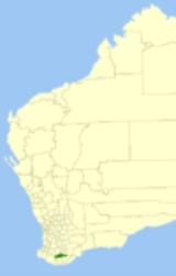
The Shire of Cranbrook is a Local Government Area
in the Great Southern region of Western Australia
, about 92 kilometres (57 mi) north of Albany
and about 320 kilometres (199 mi) south-southeast of the state capital, Perth
. The Shire covers an area of 3277 square kilometres (1,265 sq mi), and its seat of government is the town of Cranbrook
.
Local Government Areas of Western Australia
The Australian state of Western Australia is divided into 141 local government areas...
in the Great Southern region of Western Australia
Western Australia
Western Australia is a state of Australia, occupying the entire western third of the Australian continent. It is bounded by the Indian Ocean to the north and west, the Great Australian Bight and Indian Ocean to the south, the Northern Territory to the north-east and South Australia to the south-east...
, about 92 kilometres (57 mi) north of Albany
Albany, Western Australia
Albany is a port city in the Great Southern region of Western Australia, some 418 km SE of Perth, the state capital. As of 2009, Albany's population was estimated at 33,600, making it the 6th-largest city in the state....
and about 320 kilometres (199 mi) south-southeast of the state capital, Perth
Perth, Western Australia
Perth is the capital and largest city of the Australian state of Western Australia and the fourth most populous city in Australia. The Perth metropolitan area has an estimated population of almost 1,700,000....
. The Shire covers an area of 3277 square kilometres (1,265 sq mi), and its seat of government is the town of Cranbrook
Cranbrook, Western Australia
Cranbrook is a small town in the Great Southern region of Western Australia between Katanning, Kojonup and Mount Barker, situated 320km south of Perth. It is billed as "The Gateway to the Stirlings", referring to the nearby Stirling Range National Park...
.
History
The Cranbrook Road Board was gazetted in 1926. On 1 July 1961, it became a Shire Council following changes to the Local Government Act.Wards
The shire is divided into 3 wards, each with 3 councillors:- East Ward
- Central Ward
- West Ward
Towns and localities
- CranbrookCranbrook, Western AustraliaCranbrook is a small town in the Great Southern region of Western Australia between Katanning, Kojonup and Mount Barker, situated 320km south of Perth. It is billed as "The Gateway to the Stirlings", referring to the nearby Stirling Range National Park...
- FranklandFrankland, Western AustraliaFrankland is a small town in the Great Southern Region of Western Australia. The town is in the shire of Cranbrook and is situated approximately 360 km from the State's capital, Perth, 42 km west of the Albany Highway, 83 km southwest of Kojonup, 19 km north of Rocky Gully and...
- TenterdenTenterden, Western AustraliaTenterden is a town located 328 km south-east of Perth in the Great Southern region of Western Australia. The townsite is located on one of the sidings on the Great Southern Railway line. The siding was established in 1891 and shortly afterward the government made land available for agricultural...