
Shirahama, Wakayama
Encyclopedia
Towns of Japan
A town is a local administrative unit in Japan. It is a local public body along with prefecture , city , and village...
located in Nishimuro District, Wakayama
Nishimuro District, Wakayama
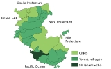
is a district located in Wakayama, Japan. As of September 1, 2008, the district has an estimated Population of 42,840 and a Density of 98.9 persons/km²...
, Japan
Japan
Japan is an island nation in East Asia. Located in the Pacific Ocean, it lies to the east of the Sea of Japan, China, North Korea, South Korea and Russia, stretching from the Sea of Okhotsk in the north to the East China Sea and Taiwan in the south...
.
On March 1, 2006 the town of Hikigawa
Hikigawa, Wakayama
was a town located in Nishimuro District, Wakayama, Japan.On March 1, 2006 Hikigawa was merged into the expanded town of Shirahama.As of , the town had an estimated population of 4,594 and a density of 33.70 persons per km² The total area was 136.31 km.²...
, from Nishimuro District
Nishimuro District, Wakayama
is a district located in Wakayama, Japan. As of September 1, 2008, the district has an estimated Population of 42,840 and a Density of 98.9 persons/km²...
, was merged into Shirahama.
As of September 1, 2007, the town has an estimated population
Population
A population is all the organisms that both belong to the same group or species and live in the same geographical area. The area that is used to define a sexual population is such that inter-breeding is possible between any pair within the area and more probable than cross-breeding with individuals...
of 23,180 and a population density
Population density
Population density is a measurement of population per unit area or unit volume. It is frequently applied to living organisms, and particularly to humans...
of 115 persons per km². The total area is 201.04 km².
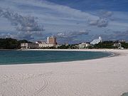
Shirahama is a resort town on the south coast of Wakayama Prefecture
Wakayama Prefecture
is a prefecture of Japan located on the Kii Peninsula in the Kansai region on Honshū island. The capital is the city of Wakayama.- History :Present-day Wakayama is mostly the western part of the province of Kii.- 1953 Wakayama Prefecture flood disaster :...
. Its beaches are white sand, imported from Australia
Australia
Australia , officially the Commonwealth of Australia, is a country in the Southern Hemisphere comprising the mainland of the Australian continent, the island of Tasmania, and numerous smaller islands in the Indian and Pacific Oceans. It is the world's sixth-largest country by total area...
. Shirahama is also known for its hot springs
Onsen
An is a term for hot springs in the Japanese language, though the term is often used to describe the bathing facilities and inns around the hot springs. As a volcanically active country, Japan has thousands of onsen scattered along its length and breadth...
. During the summer (July and August), there are fireworks every night on the beach.
Shirahama is about two and a half hours from Osaka
Osaka
is a city in the Kansai region of Japan's main island of Honshu, a designated city under the Local Autonomy Law, the capital city of Osaka Prefecture and also the biggest part of Keihanshin area, which is represented by three major cities of Japan, Kyoto, Osaka and Kobe...
by JR West
West Japan Railway Company
, also referred to as , is one of the Japan Railways Group companies and operates in western Honshū. It has its headquarters in Kita-ku, Osaka.-History:...
's Ocean Arrow train service. There are also daily flights from Nanki-Shirahama Airport
Nanki-Shirahama Airport
is a third class airport in Shirahama, Wakayama, Japan. It serves the southern part of the Kii Peninsula with three daily Japan Airlines round-trips to Tokyo International Airport.-Airlines and destinations:-External links:* in Japanese...
to Tokyo's Tokyo International Airport
Tokyo International Airport
, commonly known as , is one of the two primary airports that serve the Greater Tokyo Area in Japan. It is located in Ōta, Tokyo, south of Tokyo Station....
(Haneda).
Geography
Located in southeastern Wakayama PrefectureWakayama Prefecture
is a prefecture of Japan located on the Kii Peninsula in the Kansai region on Honshū island. The capital is the city of Wakayama.- History :Present-day Wakayama is mostly the western part of the province of Kii.- 1953 Wakayama Prefecture flood disaster :...
, the town has a temperate
Temperate
In geography, temperate or tepid latitudes of the globe lie between the tropics and the polar circles. The changes in these regions between summer and winter are generally relatively moderate, rather than extreme hot or cold...
climate. Many hot springs
Hot Springs
Hot Springs may refer to:* Hot Springs, Arkansas** Hot Springs National Park, Arkansas*Hot Springs, California**Hot Springs, Lassen County, California**Hot Springs, Modoc County, California**Hot Springs, Placer County, California...
can be found here, most notably Nanki Shirahama Onsen and Tsubaki Onsen. Also, two paths that are located in the town are part of a World Heritage site. Shirahama is known to be one of the very few municipalities in Japan that do not have "azas", or towns and villages that previously existed within the boundaries of the present day Shirahama.
Places of note
- Kumano Kodo: an old road: Cliffs along on the ocean edge that are 50 meters high. It is said that pirates (kumano suigun) used to inhabit the caverns; the remains of their dwellings can be seen.: A rocky point near Shirahama beach.
- The Minakata Kumagusu Museum houses much of scientist Minakata KumagusuMinakata Kumagusuwas a Japanese author and naturalist.-Biography:Minakata was born in Wakayama, Wakayama Prefecture, Japan. In 1883, he moved to Tokyo, where he entered the preparatory school Kyōryū Gakkō. The headmaster of Kyōritsu, Takahashi Korekiyo, encouraged Minakata in his botanical studies as well as got...
's books, specimens, and memorabilia. - Engetsu-tō: A natural archNatural archA natural arch or natural bridge is a natural geological formation where a rock arch forms, with an opening underneath. Most natural arches form as a narrow ridge, walled by cliffs, become narrower from erosion, with a softer rock stratum under the cliff-forming stratum gradually eroding out until...
just off the coast