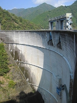
Shintoyone Dam
Encyclopedia
The Shintoyone Dam is a multipurpose dam
in the village of Toyone
in the Aichi Prefecture
of Japan
.
, and it was not until the Taishō period
that development began on the Tenryū River. With the completion of the Sakuma Dam
, one of the one of the tallest dams in Japan, on the main stream of the Tenryū River, developers turned their eyes to the confluence of the Ōnyugawa (大入川), a major tributary of the Tenryū River, and the Ōchisegawa (大千瀬川) in Aichi Prefecture. The Ōnyugawa was also of interest in that it was prone to flooding. Preliminary design work began in 1962, with construction beginning in 1969 after some opposition from the 100 households who needed to be relocated, and over increasing controversy regarding the issues of dams on the Tenryū and Ōi rivers rapidly filling with sand and silt from the mountains upstream, with the resultant reduction of the amount of sand and silt reaching the river mouth creating problems with coastal erosion. Construction was completed by the Kumagai Gumi
in August 1973.
which creates the lower reservoir of the scheme.
.
Dam
A dam is a barrier that impounds water or underground streams. Dams generally serve the primary purpose of retaining water, while other structures such as floodgates or levees are used to manage or prevent water flow into specific land regions. Hydropower and pumped-storage hydroelectricity are...
in the village of Toyone
Toyone, Aichi
is a village located in Kitashitara District, Aichi Prefecture, Japan. As of 2010, the village had an estimated population of 1,315 and a population density of 8.43 persons per km². The total area was 155.91 km².-Geography:...
in the Aichi Prefecture
Aichi Prefecture
is a prefecture of Japan located in the Chūbu region. The region of Aichi is also known as the Tōkai region. The capital is Nagoya. It is the focus of the Chūkyō Metropolitan Area.- History :...
of Japan
Japan
Japan is an island nation in East Asia. Located in the Pacific Ocean, it lies to the east of the Sea of Japan, China, North Korea, South Korea and Russia, stretching from the Sea of Okhotsk in the north to the East China Sea and Taiwan in the south...
.
History
The potential of the Tenryū River valley for hydroelectric power development was realized by the Meiji government at the start of the 20th century. The Tenryū River was characterized by a high volume of flow and a fast current. Its mountainous upper reaches and tributaries were areas of steep valleys and abundant rainfall, and were sparsely populated. However, the bulk of investment in hydroelectric power generation in the region was centered on the Ōi RiverOi River
The is a river in Shizuoka Prefecture, Japan.-Geography:The Ōi River flows from the Akaishi Mountains, the branch of the Japanese Southern Alps which form the border between Shizuoka, Nagano and Yamanashi prefectures. These mountains, with peaks ranging from 2000–3000 meters, are characterized by...
, and it was not until the Taishō period
Taisho period
The , or Taishō era, is a period in the history of Japan dating from July 30, 1912 to December 25, 1926, coinciding with the reign of the Taishō Emperor. The health of the new emperor was weak, which prompted the shift in political power from the old oligarchic group of elder statesmen to the Diet...
that development began on the Tenryū River. With the completion of the Sakuma Dam
Sakuma Dam
The is a dam on the Tenryū River, located on the border of Toyone, Kitashitara District, Aichi Prefecture on the island of Honshū, Japan. It is one of the tallest dams in Japan and supports a 350 MW hydroelectric power station...
, one of the one of the tallest dams in Japan, on the main stream of the Tenryū River, developers turned their eyes to the confluence of the Ōnyugawa (大入川), a major tributary of the Tenryū River, and the Ōchisegawa (大千瀬川) in Aichi Prefecture. The Ōnyugawa was also of interest in that it was prone to flooding. Preliminary design work began in 1962, with construction beginning in 1969 after some opposition from the 100 households who needed to be relocated, and over increasing controversy regarding the issues of dams on the Tenryū and Ōi rivers rapidly filling with sand and silt from the mountains upstream, with the resultant reduction of the amount of sand and silt reaching the river mouth creating problems with coastal erosion. Construction was completed by the Kumagai Gumi
Kumagai Gumi
is a construction company founded in Fukui, Fukui Prefecture, Japan. The company still has registered headquarters in Fukui, but the actual head office is located in Shinjuku, Tokyo.Kumagai Gumi was removed from the Nikkei 225 index on Oct...
in August 1973.
Design
The Shintoyone Dam is a concrete arch dam with a height of 116.5 m (382 ft) meters and a length of 311 m (1,020 ft) meters. It impounds a reservoir called with a surface area of 156.0 hectares. The catchment basin for the reservoir is 136.3 square kilometre square kilometers. The reservoir is connected by two 1884 m (6,181 ft) tunnels to the 1,125 MW pumped-storage hydroelectric power plant constructed next to the Sakuma DamSakuma Dam
The is a dam on the Tenryū River, located on the border of Toyone, Kitashitara District, Aichi Prefecture on the island of Honshū, Japan. It is one of the tallest dams in Japan and supports a 350 MW hydroelectric power station...
which creates the lower reservoir of the scheme.
Surroundings
The Shintone Dam Reservoir is a popular attraction as the surrounding area is part of the Tenryū-Okumikawa Quasi-National ParkTenryū-Okumikawa Quasi-National Park
is a quasi-national park in the Tokai region of Honshū in Japan. It is rated a protected landscape according to the IUCN. The park includes the gorges of the upper Tenryū River, Sakuma Dam and its surrounding forests, Atera Seven Falls, Chausu Mountains and Mount Horaiji. It straddles the border...
.

