
Shangla District
Encyclopedia
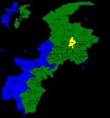
Shangla District is located in the Khyber-Pakhtunkhwa province of Pakistan
.
The district headquarters are located at Alpuri
. It was previously a subdivision of Swat District, but was upgraded to the status of a district on July 10, 1995 by the then Chief Minister Aftab Khan Sherpao. The total area of the district is 1,586 square kilometres. Pashto is spoken by most of the population.
Shangla comprises two sub division, Alpuri
and Puran Tehsil
. There are four (4) sub tehsil
s i.e. Besham
, Chakesar
, Martung
and Makhuzai
.
Shangla has the lowest Human Development Index
in the province and second lowest in the country.
, in the east by Battagram District and the tribal area of Kala Dhaka (Black Mountain of Hazara), in the west by Swat District and in the south by Buner District
.
and Daut. it is believed that Alexander the Great camped at Pirsar for a few days. There are also relics of the Hindu Shahi in Qlandar-Ajmair
Alexander the great visied Persar Dandai and then went back from the place without further conquering.
The communications with Swat, are Shangla pass (Shangla top)
Shangla district, consists of small valleys, is situated between the hillocks and surrounded by high mountains full of forests comprising Pindrow Fir
, Morinda Spruce
, Blue Pine
(Kail), Chir Pine
and Deodar Cedar
trees. The average elevation of the district is 2000 to 3000 meters above sea level. The highest point (3,440 m) is near Kuz Ganrshal in the north of the district. There are beautiful isolated valleys most suitable for seed production of highly demanded cross pollinated vegetable crops. Moreover Shangla has got pretty enough potential for hydel power generation, one such project underway is at Khan Khwar.
and four (4) Sub-Tehsils, namely
There are 28 Union Councils
. Alpuri
Tehsil (Sub division) consists of 19 Union Councils and Puran
Tehsil (Sub-division) consists of 9 Union Councils.
Almost the entire population of Shangla belongs to the Pathan
tribe Yousafzai. Major subtribes of Yousafzai living in Shangla are Akhun Khail living In Besham Tehsil and in Shahpur and Kabal Gram Moreover Mian Khail,Mula Khail living in Lilownai,Azikhel and Babozai. Azikhel live mainly in Ghwarband, Chakesar
, Martung
and Shahpur while Babozai live in Puran
. The People of Shangla are known for their hospitality. Almost the entire population is Muslim (99.8%) with very small numbers of Christians, Hindus, and Ahmadis.
It was severely hit during the October 8, 2005 earthquake and many people were left homeless.
(Pakhtun tribe Yousafzai
s) with locals migrating into Hazara.
Pakistan
Pakistan , officially the Islamic Republic of Pakistan is a sovereign state in South Asia. It has a coastline along the Arabian Sea and the Gulf of Oman in the south and is bordered by Afghanistan and Iran in the west, India in the east and China in the far northeast. In the north, Tajikistan...
.
The district headquarters are located at Alpuri
Alpuri
Alpuri or Alpurai is the capital of Shangla District in the Khyber-Pakhtunkhwa province of Pakistan. It is located at and has an average elevation of 1471 metres 4829 feet).-2007 fighting:...
. It was previously a subdivision of Swat District, but was upgraded to the status of a district on July 10, 1995 by the then Chief Minister Aftab Khan Sherpao. The total area of the district is 1,586 square kilometres. Pashto is spoken by most of the population.
Shangla comprises two sub division, Alpuri
Alpuri
Alpuri or Alpurai is the capital of Shangla District in the Khyber-Pakhtunkhwa province of Pakistan. It is located at and has an average elevation of 1471 metres 4829 feet).-2007 fighting:...
and Puran Tehsil
Puran Tehsil
Puran is a sub-division and tehsil of Shangla District in Khyber-Pakhtunkhwa province of Pakistan. The subdivision includes three tehsils viz: Puran itself, Martung and Makhuzai.Puran Sub-division comprises nine Union Councils...
. There are four (4) sub tehsil
Tehsil
A Tehsil or Tahsil/Tahasil , also known as Taluk and Mandal, is an administrative division of some country/countries of South Asia....
s i.e. Besham
Besham
Besham is the largest town and commercial centre of the Shangla District in Khyber-Pakhtunkhwa province of Pakistan. Most of the population is pashto speaking pashtun....
, Chakesar
Chakesar
Chakesar is a town of the Shangla District in Khyber-Pakhtunkhwa province of Pakistan. It is situated about 6 km in the north-west on the right bank of the Indus River. The inhabitants primarily live on agriculture...
, Martung
Martung
Martung , Mārtung or Martoong is a highland village and sub tehsil of Shangla District, Khyber Pakhtunkhwa , Pakistan included in Puran Subdivision. Central Martung is 982 meters above sea level., Being not plain area, some parts of Martung are even more than 1800 meters above mean sea level...
and Makhuzai
Makhuzai
Makhuzai was the oldest tehsile of swat in the ruling days of wali swat, but it is now sub-tehsil of Tehsil Puran District Shangla, Pakistan...
.
Shangla has the lowest Human Development Index
Human Development Index
The Human Development Index is a composite statistic used to rank countries by level of "human development" and separate "very high human development", "high human development", "medium human development", and "low human development" countries...
in the province and second lowest in the country.
Location
The district is bounded in the north by Kohistan DistrictKohistan District
Kohistan District may refer to one of the following:in Afghanistan* Kohistan District, Badakhshan* Kohistan District, Faryab* Kohistan District, Kapisa...
, in the east by Battagram District and the tribal area of Kala Dhaka (Black Mountain of Hazara), in the west by Swat District and in the south by Buner District
Buner District
Buner District is a district of the Khyber Pakhtunkhwa province of Pakistan.- History :The Buner Valley lies on the Peshawar valley border of the Khyber Pakhtunkhwa. It is a small mountain valley, dotted with villages and divided into seven sub-divisions...
.
History
There are relics of the ancient Greek period at Pirsar, ChakesarChakesar
Chakesar is a town of the Shangla District in Khyber-Pakhtunkhwa province of Pakistan. It is situated about 6 km in the north-west on the right bank of the Indus River. The inhabitants primarily live on agriculture...
and Daut. it is believed that Alexander the Great camped at Pirsar for a few days. There are also relics of the Hindu Shahi in Qlandar-Ajmair
Alexander the great visied Persar Dandai and then went back from the place without further conquering.
Geography
the north of shangla is kalam in west hazara in east kohistan and in the west is swat.The communications with Swat, are Shangla pass (Shangla top)
Shangla district, consists of small valleys, is situated between the hillocks and surrounded by high mountains full of forests comprising Pindrow Fir
Pindrow Fir
The Pindrow Fir or West Himalayan Fir is a fir native to the western Himalaya and adjacent mountains, from northeast Afghanistan east through northern Pakistan and India to central Nepal...
, Morinda Spruce
Morinda Spruce
Picea smithiana, the Morinda Spruce or West Himalayan Spruce, is a spruce native to the western Himalaya and adjacent mountains, from northeast Afghanistan east to central Nepal...
, Blue Pine
Blue Pine
Pinus wallichiana is a pine native to the Himalaya, Karakoram and Hindu Kush mountains, from eastern Afghanistan east across northern Pakistan and India to Yunnan in southwest China. It grows at high altitudes in mountain valleys at altitudes of 1800–4300 m , and is a tree from 30–50 m in height...
(Kail), Chir Pine
Chir Pine
The Chir Pine, Pinus roxburghii, named after William Roxburgh, is a pine native to the Himalaya.The range extends from northern Pakistan , across northern India and Nepal to Bhutan.It generally occurs at lower altitudes than other pines in the Himalaya, from...
and Deodar Cedar
Deodar Cedar
Cedrus deodara is a species of cedar native to the western Himalayas in eastern Afghanistan, northern Pakistan, north-central India , southwesternmost Tibet and western Nepal, occurring at 1500–3200 m altitude...
trees. The average elevation of the district is 2000 to 3000 meters above sea level. The highest point (3,440 m) is near Kuz Ganrshal in the north of the district. There are beautiful isolated valleys most suitable for seed production of highly demanded cross pollinated vegetable crops. Moreover Shangla has got pretty enough potential for hydel power generation, one such project underway is at Khan Khwar.
Administrative divisions
Under the devolved local government system Shangla is divided into two Sub-Divivisions/Tehsils namely:-- AlpuriAlpuriAlpuri or Alpurai is the capital of Shangla District in the Khyber-Pakhtunkhwa province of Pakistan. It is located at and has an average elevation of 1471 metres 4829 feet).-2007 fighting:...
and - Puran TehsilPuran TehsilPuran is a sub-division and tehsil of Shangla District in Khyber-Pakhtunkhwa province of Pakistan. The subdivision includes three tehsils viz: Puran itself, Martung and Makhuzai.Puran Sub-division comprises nine Union Councils...
and four (4) Sub-Tehsils, namely
- BeshamBeshamBesham is the largest town and commercial centre of the Shangla District in Khyber-Pakhtunkhwa province of Pakistan. Most of the population is pashto speaking pashtun....
- ChakesarChakesarChakesar is a town of the Shangla District in Khyber-Pakhtunkhwa province of Pakistan. It is situated about 6 km in the north-west on the right bank of the Indus River. The inhabitants primarily live on agriculture...
- MartungMartungMartung , Mārtung or Martoong is a highland village and sub tehsil of Shangla District, Khyber Pakhtunkhwa , Pakistan included in Puran Subdivision. Central Martung is 982 meters above sea level., Being not plain area, some parts of Martung are even more than 1800 meters above mean sea level...
- MakhuzaiMakhuzaiMakhuzai was the oldest tehsile of swat in the ruling days of wali swat, but it is now sub-tehsil of Tehsil Puran District Shangla, Pakistan...
There are 28 Union Councils
Union Councils of Pakistan
A sherwan or village council in Pakistan is an elected local government body consisting of 21 councillors, and headed by a nazim and a naib nazim...
. Alpuri
Alpuri
Alpuri or Alpurai is the capital of Shangla District in the Khyber-Pakhtunkhwa province of Pakistan. It is located at and has an average elevation of 1471 metres 4829 feet).-2007 fighting:...
Tehsil (Sub division) consists of 19 Union Councils and Puran
Puran
Puran Puran Tehsil is a sub-division and tehsil of Shangla District in Khyber-Pakhtunkhwa province of Pakistan....
Tehsil (Sub-division) consists of 9 Union Councils.
Population
According to the 1998 census, the district had a population of 435,563 with an average annual growth rate of 3.3% and population density of 274 persons per square kilometre. The total number of households is 64,391 with an average household size of 8.1.Almost the entire population of Shangla belongs to the Pathan
Pashtun people
Pashtuns or Pathans , also known as ethnic Afghans , are an Eastern Iranic ethnic group with populations primarily between the Hindu Kush mountains in Afghanistan and the Indus River in Pakistan...
tribe Yousafzai. Major subtribes of Yousafzai living in Shangla are Akhun Khail living In Besham Tehsil and in Shahpur and Kabal Gram Moreover Mian Khail,Mula Khail living in Lilownai,Azikhel and Babozai. Azikhel live mainly in Ghwarband, Chakesar
Chakesar
Chakesar is a town of the Shangla District in Khyber-Pakhtunkhwa province of Pakistan. It is situated about 6 km in the north-west on the right bank of the Indus River. The inhabitants primarily live on agriculture...
, Martung
Martung
Martung , Mārtung or Martoong is a highland village and sub tehsil of Shangla District, Khyber Pakhtunkhwa , Pakistan included in Puran Subdivision. Central Martung is 982 meters above sea level., Being not plain area, some parts of Martung are even more than 1800 meters above mean sea level...
and Shahpur while Babozai live in Puran
Puran
Puran Puran Tehsil is a sub-division and tehsil of Shangla District in Khyber-Pakhtunkhwa province of Pakistan....
. The People of Shangla are known for their hospitality. Almost the entire population is Muslim (99.8%) with very small numbers of Christians, Hindus, and Ahmadis.
Demographics
Most of the local inhabitants are agriculturists. Though the agricultural area of the district is fertile but the agricultural holdings are very small as compared to the number of owners. The total cultivated area of the district is 423.6 square kilometres (104,673.7 acre) out of which only 30.75 square kilometres (7,598.5 acre) is irrigated and the remaining 392.85 square kilometres (97,075.3 acre) is non-irrigated. Shangla District is full of natural resources, having a vast scope for investment and development.It was severely hit during the October 8, 2005 earthquake and many people were left homeless.
Flora
A number of medicinal plants are found in the area including the following:- Tarkha (Artemizia species)
- Unab (Zizyphus Sativa)
- Althea (Althaca Officinalis)
- Banafsha (Viola serpens)
- Mushki Bala (Valeriana species)
- Musli Sufed (Aspargus species)
Fauna
The district is home to a variety of fauna including deer, bears, pheasants and leopards.- Markhur (Capre falconeri)
- Himalayan ibex (Capre ibex sibirica)
- Urial (Ovis orientalis)
- Himalyan black bear (Selenaretos thibetanus)
- Brown bear (Ursus arctos)
- Bear (Lepus nigricollis)
- Leopard (Panthera pardus)
- Snow leopard (Panthera UnciaSnow LeopardThe snow leopard is a moderately large cat native to the mountain ranges of South Asia and Central Asia...
) - Wolf (Canis lupus pallipes)
- Rhesus Monkey (Maaca mulatta)
- Blue rock pigeon (Columba livia)
- Spotted dove (Streptopelia chinensis)
- Little brown dove (s. senegalensis)
- Chakor (Alectoris chukar)
- Himalayan snow cock (Tetracollus himalayensis)
- Red jungle fowl (Gallus gallus)
- Monal pheasant (Lphororus impejanus)
- Koklas pheasant (Pucrasis macrolopha)
- Satyr tragopan (Tragopan satyra)
- Hoopoe (Lupupa epops)
- White breasted kingfisher (Halcyon smyrensis)
- Indian robin (Saxicoloides fullicota)
Well-known sites
Shangla is also a historical place in South Asia: home to several Buddhist hermits, as well as a small but thriving Hindu community in the Chakesar region. It is said that the region known as Ghorband in the north west of Shangla was visited by Alexander the Great's Army in 326 B.C. where it fought a battle with the locals at the mount Pir Sar. Later on in the 15th century Shangla witnessed a population shift from neighbouring AfghanistanAfghanistan
Afghanistan , officially the Islamic Republic of Afghanistan, is a landlocked country located in the centre of Asia, forming South Asia, Central Asia and the Middle East. With a population of about 29 million, it has an area of , making it the 42nd most populous and 41st largest nation in the world...
(Pakhtun tribe Yousafzai
Yousafzai
The Yūsufzai is one of the largest Pashtun tribes...
s) with locals migrating into Hazara.