
Second East-West Highway
Encyclopedia
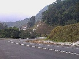
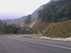
Second East-West Highway, Federal Route is a highway in Peninsular Malaysia
which connects Simpang Pulai
in Perak
to Gua Musang
in Kelantan
. The highway is expected to be extended further east to Kuala Terengganu
in the future. This highway features a four-lane carriageway from Simpang Pulai
to Cameron Highlands
and a two-lane carriageway from Cameron Highlands
to Gua Musang
. It is notorious for its many sharp corners which increase the risk of road accidents.
, Perak
, at its junctions with the Federal Route
, the main trunk road of the central of Peninsular Malaysia.
. The construction of the highway began in 2001 and was completed in 2004. Phase 2 should be completed by end 2010.
, Pahang
, Kelantan
and Terengganu
,
starting at Simpang Pulai
and traversing through the main range at Lojing, and ending at Kuala Berang
.
 The total distance of the proposed road is 313.66 km (194.9 mi), excluding the 41 km (-- miles) existing road from
Gua Musang
to Chiku, Kelantan
. The road is designed to Malaysian Public Works Department
(JKR) geometric standard of R3
with a design speed of 50 km/h (-- mph).
In terms of riding comfort, this R3 standard falls in between the R5 or R6 standard for
expressway (typically with a design speed of 80-110 km/h (-- mph)) and R1 or R2 standard
such as the winding hilly road (typically with a design speed of 20-30 km/h (-- mph)).
Typically, the road is a two-lane single carriageway with a lane width of 3.5m (-- ft) and shoulder
width of 2.5m (-- ft). Climbing lanes are also provided at certain sections with steep gradient, to
assist slow moving vehicles. The project also involves the construction of viaducts, bridges
and culverts.
Peninsular Malaysia
Peninsular Malaysia , also known as West Malaysia , is the part of Malaysia which lies on the Malay Peninsula. Its area is . It shares a land border with Thailand in the north. To the south is the island of Singapore. Across the Strait of Malacca to the west lies the island of Sumatra...
which connects Simpang Pulai
Simpang Pulai
Simpang Pulai is a town in Malaysia located between Sungai Raia and Chandan Desa.A Ria Moda Jakel Trading Textile Company opened its branch here at the corner lot of the Simpang Pulai intersection. An alternative road leading to Cameron Highlands also started from the same intersection. A huge...
in Perak
Perak
Perak , one of the 13 states of Malaysia, is the second largest state in the Peninsular Malaysia bordering Kedah and Yala Province of Thailand to the north, Penang to the northwest, Kelantan and Pahang to the east, Selangor the Strait of Malacca to the south and west.Perak means silver in Malay...
to Gua Musang
Gua Musang
Gua Musang is a town and territory in Kelantan, Malaysia. It is the largest district in Kelantan. Gua Musang is administered by the Gua Musang District Council. Gua Musang district is bordered by the state of Pahang to the south, Terengganu to the east, Perak to the west and the Kelantanese...
in Kelantan
Kelantan
Kelantan is a state of Malaysia. The capital and royal seat is Kota Bharu. The Arabic honorific of the state is Darul Naim, ....
. The highway is expected to be extended further east to Kuala Terengganu
Kuala Terengganu
-Transport:The city is connected to other towns via a good network of roads and also some ferries that ply the Terengganu River. The Sultan Mahmud Bridge, a bridge over the Terengganu River, provides a road link to both banks of the river...
in the future. This highway features a four-lane carriageway from Simpang Pulai
Simpang Pulai
Simpang Pulai is a town in Malaysia located between Sungai Raia and Chandan Desa.A Ria Moda Jakel Trading Textile Company opened its branch here at the corner lot of the Simpang Pulai intersection. An alternative road leading to Cameron Highlands also started from the same intersection. A huge...
to Cameron Highlands
Cameron Highlands
The Cameron Highlands is one of Malaysia’s most extensive hill stations. It covers an area of .To the north, its boundary touches that of Kelantan; to the west, it shares part of its border with Perak....
and a two-lane carriageway from Cameron Highlands
Cameron Highlands
The Cameron Highlands is one of Malaysia’s most extensive hill stations. It covers an area of .To the north, its boundary touches that of Kelantan; to the west, it shares part of its border with Perak....
to Gua Musang
Gua Musang
Gua Musang is a town and territory in Kelantan, Malaysia. It is the largest district in Kelantan. Gua Musang is administered by the Gua Musang District Council. Gua Musang district is bordered by the state of Pahang to the south, Terengganu to the east, Perak to the west and the Kelantanese...
. It is notorious for its many sharp corners which increase the risk of road accidents.
Route background
The Kilometre Zero of the Federal Route 185 is located at Simpang PulaiSimpang Pulai
Simpang Pulai is a town in Malaysia located between Sungai Raia and Chandan Desa.A Ria Moda Jakel Trading Textile Company opened its branch here at the corner lot of the Simpang Pulai intersection. An alternative road leading to Cameron Highlands also started from the same intersection. A huge...
, Perak
Perak
Perak , one of the 13 states of Malaysia, is the second largest state in the Peninsular Malaysia bordering Kedah and Yala Province of Thailand to the north, Penang to the northwest, Kelantan and Pahang to the east, Selangor the Strait of Malacca to the south and west.Perak means silver in Malay...
, at its junctions with the Federal Route
Malaysia Federal Route 1
Federal Route 1 is the first federal road in Malaysia, and among the oldest federal roads in Malaysia, having been constructed by the British government during colonial times...
, the main trunk road of the central of Peninsular Malaysia.
History
The highway was formerly known as Perak State Route from Simpang Pulai to Pos Slim before being extended eastwards and recommissioned as a federal highwayMalaysian Federal Roads System
Malaysian Federal Roads System , is the main national road network in Malaysia. All Federal Roads in Malaysia are under the purview of Ministry of Works . According to Minister's Function Act 1969, MOW responsible to plan, build and maintain all Federal Roads gazetted under the Federal Road Act 1959...
. The construction of the highway began in 2001 and was completed in 2004. Phase 2 should be completed by end 2010.
Location of the project
The proposed route runs through the states of PerakPerak
Perak , one of the 13 states of Malaysia, is the second largest state in the Peninsular Malaysia bordering Kedah and Yala Province of Thailand to the north, Penang to the northwest, Kelantan and Pahang to the east, Selangor the Strait of Malacca to the south and west.Perak means silver in Malay...
, Pahang
Pahang
Pahang is the third largest state in Malaysia, after Sarawak and Sabah, occupying the huge Pahang River river basin. It is bordered to the north by Kelantan, to the west by Perak, Selangor, Negeri Sembilan, to the south by Johor and to the east by Terengganu and the South China Sea.Its state...
, Kelantan
Kelantan
Kelantan is a state of Malaysia. The capital and royal seat is Kota Bharu. The Arabic honorific of the state is Darul Naim, ....
and Terengganu
Terengganu
Terengganu is a sultanate and constitutive state of federal Malaysia. The state is also known by its Arabic honorific, Darul Iman...
,
starting at Simpang Pulai
Simpang Pulai
Simpang Pulai is a town in Malaysia located between Sungai Raia and Chandan Desa.A Ria Moda Jakel Trading Textile Company opened its branch here at the corner lot of the Simpang Pulai intersection. An alternative road leading to Cameron Highlands also started from the same intersection. A huge...
and traversing through the main range at Lojing, and ending at Kuala Berang
Kuala Berang
Kuala Berang is the seat and largest town of Hulu Terengganu District, Terengganu, Malaysia. The town serves as a gateway to Lake Kenyir. The historical Terengganu Inscription Stone was found near Kuala Berang in 1899. The town of Kuala Berang once had been the capital of the state of Terengganu...
.
Project scope of work
Gua Musang
Gua Musang
Gua Musang is a town and territory in Kelantan, Malaysia. It is the largest district in Kelantan. Gua Musang is administered by the Gua Musang District Council. Gua Musang district is bordered by the state of Pahang to the south, Terengganu to the east, Perak to the west and the Kelantanese...
to Chiku, Kelantan
Kelantan
Kelantan is a state of Malaysia. The capital and royal seat is Kota Bharu. The Arabic honorific of the state is Darul Naim, ....
. The road is designed to Malaysian Public Works Department
Malaysian Public Works Department
Malaysian Public Works Department ' or Jabatan Kerja Raya Malaysia ' is the federal government department in Malaysia under Malaysian Ministry of Works which is responsible for construction and maintenance of public infrastructure in Malaysia such as federal and state roads, public government...
(JKR) geometric standard of R3
with a design speed of 50 km/h (-- mph).
In terms of riding comfort, this R3 standard falls in between the R5 or R6 standard for
expressway (typically with a design speed of 80-110 km/h (-- mph)) and R1 or R2 standard
such as the winding hilly road (typically with a design speed of 20-30 km/h (-- mph)).
Typically, the road is a two-lane single carriageway with a lane width of 3.5m (-- ft) and shoulder
width of 2.5m (-- ft). Climbing lanes are also provided at certain sections with steep gradient, to
assist slow moving vehicles. The project also involves the construction of viaducts, bridges
and culverts.
Estimated cost
The entire project is estimated to cost RM1.6 billion and divided into 10 packages for implementationNotable features
At most section, the Federal Route 185 was built under the JKR R5 road standard, allowing maximum speed limit of up to 90 km/h.Notable events
- 20 December, 2010 – Twenty-seven people, mostly ThaiThai peopleThe Thai people, or Siamese, are the main ethnic group of Thailand and are part of the larger Tai ethnolinguistic peoples found in Thailand and adjacent countries in Southeast Asia as well as southern China. Their language is the Thai language, which is classified as part of the Kradai family of...
tourist were killed when the double-decked coach bus they were travelling in crashed2010 Cameron Highlands bus crashThe 2010 Cameron Highlands bus crash was the worst road accident in Malaysian history. Twenty-seven passengers of the double-decked coach bus, mostly Thai tourist were killed in the accident which took place near Cameron Highlands of the Perak-Pahang border...
at the Second East-West Highway of the PerakPerakPerak , one of the 13 states of Malaysia, is the second largest state in the Peninsular Malaysia bordering Kedah and Yala Province of Thailand to the north, Penang to the northwest, Kelantan and Pahang to the east, Selangor the Strait of Malacca to the south and west.Perak means silver in Malay...
-PahangPahangPahang is the third largest state in Malaysia, after Sarawak and Sabah, occupying the huge Pahang River river basin. It is bordered to the north by Kelantan, to the west by Perak, Selangor, Negeri Sembilan, to the south by Johor and to the east by Terengganu and the South China Sea.Its state...
border near Cameron HighlandsCameron HighlandsThe Cameron Highlands is one of Malaysia’s most extensive hill stations. It covers an area of .To the north, its boundary touches that of Kelantan; to the west, it shares part of its border with Perak....
, PahangPahangPahang is the third largest state in Malaysia, after Sarawak and Sabah, occupying the huge Pahang River river basin. It is bordered to the north by Kelantan, to the west by Perak, Selangor, Negeri Sembilan, to the south by Johor and to the east by Terengganu and the South China Sea.Its state...
.
List of Junctions and Towns
This is a list of junctions and towns along the highway.| Km | Exit | Junctions | To | Remarks | |
|---|---|---|---|---|---|
0 |
SIMPANG PULAI Simpang Pulai Simpang Pulai is a town in Malaysia located between Sungai Raia and Chandan Desa.A Ria Moda Jakel Trading Textile Company opened its branch here at the corner lot of the Simpang Pulai intersection. An alternative road leading to Cameron Highlands also started from the same intersection. A huge... |
NORTH Ipoh Ipoh Ipoh is the capital city of Perak state, Malaysia. It is approximately 200 km north of Kuala Lumpur on the North-South Expressway.... SOUTH Batu Gajah Batu Gajah Batu Gajah is a town located in the state of Perak in Malaysia, about 24 km from Ipoh, the Perak state capital.-Origins and History:... Gopeng Gopeng Gopeng is a town located in Mukim Teja, District of Kampar, Perak, Malaysia. It is situated approximately 20 km south of Ipoh, the state capital. The town is located on the west side of the North-South Expressway stretch of Tapah-Simpang Pulai... NORTH-SOUTH EXPRESSWAY NORTHERN ROUTE North-South Expressway Northern Route North–South Expressway Northern Route, is the northern part of Malaysia's longest expressway, the North–South Expressway. It is situated on the west coast of Peninsular Malaysia, linking the northern states of Kedah, Penang, Perak and Selangor.... Bukit Kayu Hitam Penang Kuala Lumpur |
T-Junctions | ||
| SECOND EAST-WEST HIGHWAY (Phase 1) Simpang Pulai-Gua Musang Start/End of highway |
|||||
| Start/End of six-lane carriageway | |||||
| Kampung Raja --- m above sea level |
|||||
15 |
|||||
| Perak Darul Ridzuan Kinta district border |
|||||
| Perak-Pahang border --- m above sea level |
|||||
| Pahang Darul Makmur Cameron Highlands district border |
|||||
| CAMERON HIGHLANDS Cameron Highlands The Cameron Highlands is one of Malaysia’s most extensive hill stations. It covers an area of .To the north, its boundary touches that of Kelantan; to the west, it shares part of its border with Perak.... (North) --- m above sea level |
SOUTH Cameron Highlands Cameron Highlands The Cameron Highlands is one of Malaysia’s most extensive hill stations. It covers an area of .To the north, its boundary touches that of Kelantan; to the west, it shares part of its border with Perak.... Brinchang Brinchang Brinchang is a town located in Cameron Highlands in the state of Pahang, Malaysia. It is the second tourist town in Pahang after Tanah Rata... |
T-Junctions | |||
| Start/End of six-lane carriageway | |||||
| Start/End of single carriageway | |||||
| Pahang Darul Makmur Cameron Highlands district border |
|||||
| Pahang-Kelantan border --- m above sea level |
|||||
| Kelantan Darul Naim Gua Musang district border |
|||||
| Pos Sigar --- m above sea level |
Pos Sigar Orang Asli Orang Asli Orang Asli , is a generic Malaysian term used for people indigenous to Peninsular Malaysia... village |
T-junctions | |||
| Pos Brooke --- m above sea level |
Pos Brooke Orang Asli Orang Asli Orang Asli , is a generic Malaysian term used for people indigenous to Peninsular Malaysia... village |
T-junctions | |||
| Pos Mering --- m above sea level |
Pos Mering Orang Asli Orang Asli Orang Asli , is a generic Malaysian term used for people indigenous to Peninsular Malaysia... village Lojing Highlands |
T-junctions | |||
| Lojing --- m above sea level |
Lojing Highlands | T-junctions | |||
| Sungai Berok bridge --- m above sea level |
|||||
| Kampung Sungkai --- m above sea level |
|||||
| Jalan Ulu Nenggiri --- m above sea level |
WEST JALAN ULU NENGGIRI Ulu Nenggiri Kampung Pilting |
T-junctions | |||
| SECOND EAST-WEST HIGHWAY (Phase 1) Simpang Pulai-Gua Musang |
|||||
| GUA MUSANG Gua Musang Gua Musang is a town and territory in Kelantan, Malaysia. It is the largest district in Kelantan. Gua Musang is administered by the Gua Musang District Council. Gua Musang district is bordered by the state of Pahang to the south, Terengganu to the east, Perak to the west and the Kelantanese... |
NORTH JALAN DABONG-GUA MUSANG Jalan Dabong-Gua Musang Jalan Dabong-Gua Musang is a major road in Kelantan, Malaysia. The roads connects Dabong in the north to Gua Musang in the south. It is a longest state roads in Kelantan.-List of junctions:... Dabong Dabong Dabong is a small town in Kelantan, Malaysia. The famous Gua Ikan is situated nearby on the Galas River.Dabong is situated in the Jeli Municipality.-External links:... Jeli Jeli Jeli is a town and territory in Kelantan, Malaysia. As of 2000, the district's population is estimated to be 42,882. Jeli is administered by the Jeli District Council. Jeli is bordered by the state of Perak to the west, Thailand to the north, Tanah Merah district to the north east and Kuala Krai... SOUTH Kuala Lipis Kuala Lipis Kuala Lipis is a big town in Pahang, Malaysia with a population of 200,000. It is located in the district of Lipis.-History:Kuala Lipis was a gold-mining center before the British arrived in 1887. In 1898 it became the capital of Pahang until 1953.... Jerantut Jerantut Jerantut is a major town in central Pahang, Malaysia. It is located 200 kilometres from Kuala Lumpur, and 180 km from Kuantan. Jerantut is also the capital of the district of the same name. Located in the north of Pahang state, Jerantut is the main entrance to the National Park... Taman Negara Raub Raub Raub is both a town and a district in Pahang, Malaysia. The town is situated 110 km from the Malaysian capital of Kuala Lumpur and 265 km from Pahang's capital, Kuantan. Raub is one of the oldest towns in Pahang. Raub district consist of 7 mukim , namely Batu Talam, Sega, Semantan Ulu,... |
Junctions | |||
| Chiku | NORTH Kota Bharu Kota Bharu Kota Bharu is a city in Malaysia, is the state capital and Royal City of Kelantan. It is also the name of the territory in which Kota Bharu City is situated. The name means 'new city' or 'new castle/fort' in Malay. Kota Bharu is situated in the northeastern part of Peninsular Malaysia, and lies... Kuala Krai Kuala Krai Kuala Krai is a territory and town in the interior of the State of Kelantan in the north-east of Malaysia.-Kuala Krai territory:... |
T-junctions | |||
| SECOND EAST-WEST HIGHWAY (Phase 2) Gua Musang-Kuala Berang Under construction |
|||||
| Kampung Kabang --- m above sea level |
|||||
| Sungai Lebir bridge --- m above sea level |
|||||
| Kampung Lanchang --- m above sea level |
|||||
| Kelantan Darul Naim Gua Musang district border |
|||||
| Kelantan-Terengganu border --- m above sea level |
|||||
| Terengganu Darul Iman Hulu Terengganu district border |
|||||
| Sungai Kembur Viaduct --- m above sea level |
|||||
| Sungai Kelempai Viaduct --- m above sea level |
|||||
| Sungai Purun Viaduct --- m above sea level |
|||||
| Pasir Pulau Bridge Kenyir Lake --- m above sea level |
|||||
| Kenyir Lake Kenyir Lake Tasik Kenyir or Kenyir Lake is an artificial lake located in the state of Terengganu in northeast Malaysia created in 1985 by the damming of the Kenyir River to create the Sultan Mahmud Power Station.-Geography:... Pasir Pulau --- m above sea level |
Kenyir Lake Kenyir Lake Tasik Kenyir or Kenyir Lake is an artificial lake located in the state of Terengganu in northeast Malaysia created in 1985 by the damming of the Kenyir River to create the Sultan Mahmud Power Station.-Geography:... |
||||
| SECOND EAST-WEST HIGHWAY (Phase 2) Gua Musang-Kuala Berang Under construction |
|||||
| KUALA BERANG Kuala Berang Kuala Berang is the seat and largest town of Hulu Terengganu District, Terengganu, Malaysia. The town serves as a gateway to Lake Kenyir. The historical Terengganu Inscription Stone was found near Kuala Berang in 1899. The town of Kuala Berang once had been the capital of the state of Terengganu... |
SOUTH Kuala Berang |
T-junctions | |||
| EAST Bukit Payong Kuala Terengganu EAST COAST EXPRESSWAY East Coast Expressway The East Coast Expressway, ECE or is an expressway in Malaysia. It is an extension of Kuala Lumpur-Karak Expressway, which starts from Kuala Lumpur to Karak. It provides a link from the West Coast of Peninsular Malaysia to the East Coast of Peninsular Malaysia. It features a closed toll system... Kota Bharu Besut Kuala Lumpur Kuantan |
|||||
See also
- East-West HighwayEast-West Highway (Malaysia)East-West Highway, Federal Route is a highway constructed by Malaysian Public Works Department to shorten the journey from Kota Bharu, Kelantan to northwestern towns and cities of Malaysia such as Alor Star and Penang...