
San Juanico Bridge
Encyclopedia
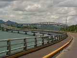
The San Juanico Bridge, part of the Pan-Philippine Highway
Pan-Philippine Highway
The Pan-Philippine Highway, also known as the Maharlika Highway is a network of roads, bridges, and ferry services that connect the islands of Luzon, Samar, Leyte, and Mindanao in the Philippines, serving as the country's principal transport backbone....
, stretches from Samar to Leyte across the San Juanico Strait
San Juanico Strait
San Juanico Strait is a narrow strait in the Philippines. It separates the islands of Samar and Leyte. At its narrowest point, the strait is only wide, said to be the narrowest strait in the world. It is crossed by the San Juanico Bridge....
in the Philippines
Philippines
The Philippines , officially known as the Republic of the Philippines , is a country in Southeast Asia in the western Pacific Ocean. To its north across the Luzon Strait lies Taiwan. West across the South China Sea sits Vietnam...
. Its longest length is a steel girder viaduct built on reinforced concrete piers, and its main span is of an arch-shaped truss design
Truss bridge
A truss bridge is a bridge composed of connected elements which may be stressed from tension, compression, or sometimes both in response to dynamic loads. Truss bridges are one of the oldest types of modern bridges...
. With a total length of 2.16 kilometres (1.3 mi), it is the longest bridge in the Philippines spanning a body of seawater. It is considered one of the most beautifully-designed bridges in Philippines. The bridge has 43 spans and medium size boats can pass beneath its large main arch the top of which rises 41 meters above the sea. Construction commenced in 1969 over San Juanico Strait from Cabalawan, Tacloban City to the municipality of Santa Rita, Samar, with completion in 1973.
The bridge was then named as Marcos Bridge after the era that was built upon. It was said to have been presented as a Gift and "Testimonial of Love" by the Philippine President Ferdinand Marcos
Ferdinand Marcos
Ferdinand Emmanuel Edralin Marcos, Sr. was a Filipino leader and an authoritarian President of the Philippines from 1965 to 1986. He was a lawyer, member of the Philippine House of Representatives and a member of the Philippine Senate...
to the first lady, Imelda
Imelda Marcos
Imelda R. Marcos is a Filipino politician and widow of 10th Philippine President Ferdinand Marcos. Upon the ascension of her husband to political power, she held various positions to the government until 1986...
, a native of Leyte.
The Candaba Viaduct
Candaba Viaduct
The Candaba Viaduct is a . bridge passing over the Candaba Swamps in the North Luzon Expressway. It is one of the longest bridges in the Philippines consists of 4 lanes . The Candaba viaduct is raised over the Candaba swamp which keeps the highway open to traffic, even when the swamp gets flooded...
of Pampanga
Pampanga
Pampanga is a province of the Philippines located in the Central Luzon region. Its capital is the City of San Fernando, Pampanga. Pampanga is bordered by the provinces of Bataan and Zambales to the west, Tarlac and Nueva Ecija to the north, and Bulacan to the southeast...
which forms part of the North Luzon Expressway is longer, but being a land bridge crossing a few streams, ponds, and a swamp which usually fills in rainy weather, is less impressive.
Connecting Tacloban City
Tacloban City
The City of Tacloban is a port city approximately 360 miles southeast of Manila. It is the first in Eastern Visayas to be classified as a Highly Urbanized City. It is the capital of the Philippine province of Leyte and is the largest city in terms of population in Eastern Visayas...
on the Leyte side and Santa Rita
Santa Rita, Samar
Santa Rita is a 4th class municipality in the province of Samar, Philippines. According to the 2000 census, it has a population of 30,118 people in 5,797 households.-Barangays:Santa Rita is politically subdivided into 38 barangays...
town on the Samar side, it offers many picturesque views, especially of the San Juanico Strait with its thousand whirlpools as well as the islets of the province. It is approximately 10 minutes from downtown Tacloban City and is accessible by passenger jeepney, bus, motorcab or private vehicle.
Construction of the 21.9 million-dollar
United States dollar
The United States dollar , also referred to as the American dollar, is the official currency of the United States of America. It is divided into 100 smaller units called cents or pennies....
bridge was contracted to the Construction and Development Corporation of the Philippines (now the Philippine National Construction Corporation
Philippine National Construction Corporation
The Philippine National Construction Corporation or PNCC is a majority government-owned and/or controlled corporation in the Philippines. It is the largest construction company in the Philippines and in Southeast Asia....
), which together with Japanese engineers conducted studies and designed the actual project.