

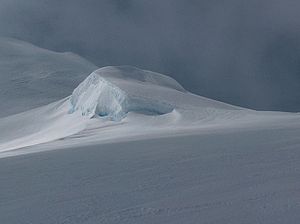
Samokov Knoll
Encyclopedia
Yankov Gap
Yankov Gap is an ice-covered saddle linking Melnik Ridge and Bowles Ridge in eastern Livingston Island in the South Shetland Islands, Antarctica. The gap is at an elevation of 575 m and extends 1 km in the north-south direction from Samokov Knoll in Melnik Ridge to Asparuh Peak in Bowles...
area, Livingston Island in the South Shetland Islands
South Shetland Islands
The South Shetland Islands are a group of Antarctic islands, lying about north of the Antarctic Peninsula, with a total area of . By the Antarctic Treaty of 1959, the Islands' sovereignty is neither recognized nor disputed by the signatories and they are free for use by any signatory for...
, Antarctica. Surmounting Kaliakra Glacier
Kaliakra Glacier
Kaliakra Glacier is a glacier in northeastern Livingston Island, Antarctica extending 7 km in east-west direction and 8 km in north-south direction...
to the northwest and Struma Glacier
Struma Glacier
Struma Glacier is a glacier in eastern Livingston Island in the South Shetland Islands, Antarctica draining the area between Bowles Ridge and Melnik Ridge. The glacier is 4.8 km long and 1.5 km wide, flowing eastwards into Moon Bay south of Sindel Point and north of Elemag Point...
to the southeast.
The peak was first visited by the Bulgarians Lyubomir Ivanov and Doychin Vasilev
Doychin Vasilev
Doychin Vasilev is a Bulgarian alpinist and cinematographer who has climbed five Himalayan 8,000 m peaks: Dhaulagiri , Mount Everest , Makalu , and Shishapangma and Cho Oyu . President of Alpine Club Vihren, Sofia...
from Camp Academia
Camp Academia
Camp Academia is a geographical locality in eastern Livingston Island, South Shetland Islands, Antarctica, named for the Bulgarian Academy of Sciences in appreciation of Academy’s contribution to the Antarctic exploration...
on 28 December 2004 and is named after the town of Samokov
Samokov
Samokov is a town in Sofia Province in the southwest of Bulgaria. It is situated in a kettle between the mountains Rila and Vitosha, 55 kilometres from the capital Sofia...
in Western Bulgaria
Bulgaria
Bulgaria , officially the Republic of Bulgaria , is a parliamentary democracy within a unitary constitutional republic in Southeast Europe. The country borders Romania to the north, Serbia and Macedonia to the west, Greece and Turkey to the south, as well as the Black Sea to the east...
.
Location
The peak is located at 62°36′18"S 60°09′31.3"W which is 480 m southwest of Melnik PeakMelnik Peak
Melnik Peak is the 696 m summit of Melnik Ridge in eastern Livingston Island, South Shetland Islands in Antarctica. Surmounting Kaliakra Glacier to the north and west, and Struma Glacier to the southeast...
, 2.46 km northwest of Atanasoff Nunatak
Atanasoff Nunatak
Atanasoff Nunatak is a nunatak, a sharp peak rising to 523 m in the east extremity of Bowles Ridge, Livingston Island, Antarctica. The peak sumounts Huron Glacier to the south and east, and Struma Glacier to the north...
, 930 m north of Asparuh Peak
Asparuh Peak
Asparuh Peak is a peak situated on Livingston Island, Antarctica. The peak rises to 760m in Bowles Ridge and is linked to the Melnik Ridge by the 575m high Yankov Gap...
, 3.18 km east of Hemus Peak
Hemus Peak
Hemus Peak is an ice-covered peak rising to 636 m off the northwest extremity of Bowles Ridge in eastern Livingston Island. The feature is breast-shaped, 850 m long in east-west direction and 550 m wide, and overlooks Kaliakra Glacier to the northeast and Perunika Glacier to the southwest...
and 4.66 km southeast of Leslie Hill
Leslie Hill, Livingston Island
Leslie Hill is a hill lying northward of Bowles Ridge and south of Vidin Heights in the eastern part of Livingston Island in the South Shetland Islands, Antarctica...
(Bulgarian topographic survey Tangra 2004/05
Tangra 2004/05
The Tangra 2004/05 Expedition was commissioned by the Antarctic Place-names Commission at the Ministry of Foreign Affairs of Bulgaria, managed by the Manfred Wörner Foundation, and supported by the Bulgarian Antarctic Institute, the Institute of Mathematics and Informatics at the Bulgarian Academy...
, and mapping in 2005 and 2009).
Maps
- L.L. Ivanov et al. Antarctica: Livingston Island and Greenwich Island, South Shetland Islands. Scale 1:100000 topographic map. Sofia: Antarctic Place-names Commission of Bulgaria, 2005.
- L.L. Ivanov. Antarctica: Livingston Island and Greenwich, Robert, Snow and Smith Islands. Scale 1:120000 topographic map. Troyan: Manfred Wörner Foundation, 2009. ISBN 978-954-92032-6-4