
.gif)
Salmon Creek (Sonoma County, California)
Encyclopedia
Salmon Creek is an 18.3 miles (29.5 km) stream
in western Sonoma County, California
that springs from coastal hills west of the town of Occidental
and empties into the Pacific Ocean
north of Bodega Head
.
. From there, it curves south and then west, passing Watson School
historic park as it parallels Bodega Highway to a confluence with Nolan Creek just east of the town of Bodega
. It flows through Bodega, then follows Salmon Creek Road westward into a narrow canyon, where it is joined by Tannery Creek, Fay Creek, Coleman Valley Creek, and Finley Creek. Salmon Creek emerges from the canyon between Irish Hill and Coleman Hill and crosses State Route 1
at milepost 12.49, entering Sonoma Coast State Beach
south of the ranger station. It parallels Bean Road to Salmon Creek Beach, which it bisects as it enters the Pacific Ocean.
people. Six Coast Miwok villages near the creek have been authenticated: Pulya-lakum, near the mouth of the creek, Kennekono and Suwutenne near the present-day town of Bodega, and three near the present day town of Freestone: Oye-yomi, Pakahuwe, and Patawa-yomi.
In 1843-44, most of the Salmon Creek watershed was included in the 35000 acres (141.6 km²) Rancho Bodega
land grant awarded to Captain Stephen Smith.
In 1873, the North Pacific Coast Railroad
built a narrow-gauge line along the stretch of Salmon Creek between Freestone and Occidental as part of the route from Sausalito
to Cazadero
.
(Syncaris pacifica), and coho salmon
(Oncorhyncus kisutch) were known to inhabit both Salmon Creek and Tannery Creek. By 2006, however, the salmon run had ceased. On July 2, 2010 the Salmon Creek Water Conservation Plan was released with important recommendations for restoring dry season instream flows, which have been exacerbated primarily by man-made water diversions, including innovative solutions such as rooftop water harvesting and re-introduction of Golden Beaver. The historic presence of beaver was evident in the first Russian-American Company
voyage by Ivan Kuskov
who sailed into Bodega Bay
in 1809 on the Kodiak and returned to Novo Arkhangelsk, Alaska (Sitka), with beaver skins and over 2,000 sea otter pelts. In 2009 and 2010 the California Department of Fish and Game
have re-introduced coho salmon into Salmon Creek.
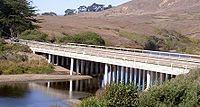 At least seven bridges span Salmon Creek. The newest and longest of these is the State Route 1 bridge, which is 200 feet (61 m) long and was built in 1983. Freestone Flat Road crosses on a steel truss 103 feet (31 m) long which was built in 1955, making it the oldest of the seven. Bodega Highway crosses in two places: 0.9 miles (1.4 km) from State Route 1 on a bridge 92 feet (28 m) long built in 1962 and at Valley Ford-Freestone Road on a 76 ft (23 m) bridge built in 1968. Salmon Creek Road spans the creek on a 78 ft (24 m) bridge dating from 1958, Bohemian Highway crosses on a 70 ft (21 m) bridge from 1971, and Scouts Camp Road crosses on a 57 ft (17 m) structure from 1960.
Stream
A stream is a body of water with a current, confined within a bed and stream banks. Depending on its locale or certain characteristics, a stream may be referred to as a branch, brook, beck, burn, creek, "crick", gill , kill, lick, rill, river, syke, bayou, rivulet, streamage, wash, run or...
in western Sonoma County, California
Sonoma County, California
Sonoma County, located on the northern coast of the U.S. state of California, is the largest and northernmost of the nine San Francisco Bay Area counties. Its population at the 2010 census was 483,878. Its largest city and county seat is Santa Rosa....
that springs from coastal hills west of the town of Occidental
Occidental, California
Occidental is a census-designated place in Sonoma County, California, United States. The population was 1,115 at the 2010 census, down from 1,272 at the 2000 census.-Geography:Occidental is located at...
and empties into the Pacific Ocean
Pacific Ocean
The Pacific Ocean is the largest of the Earth's oceanic divisions. It extends from the Arctic in the north to the Southern Ocean in the south, bounded by Asia and Australia in the west, and the Americas in the east.At 165.2 million square kilometres in area, this largest division of the World...
north of Bodega Head
Bodega Head
Bodega Head is a small promontory on the Pacific coast of northern California in the United States. It is located in Sonoma County at , approximately 40 mi northwest of San Francisco and approximately 20 mi west of Santa Rosa....
.
Course
Salmon Creek originates about 2 miles (3 km) west of the town of Occidental near the junction of Joy Road and Bittner Road. It parallels Bittner Road eastward, passing just south of Occidental, where it turns right and follows Bohemian Highway to the town of FreestoneFreestone, California
Freestone is a small, unincorporated community in Sonoma County, California, USA located at the intersection of Bohemian Highway and Bodega Highway. It's west of Sebastopol along Salmon Creek on the U.S...
. From there, it curves south and then west, passing Watson School
Watson School
Watson School is a Sonoma County Regional Parks Department historic park, covering approximately , located about east of Bodega, California, on the south side of the road, at 15000 Bodega Highway in Sonoma County, California, United States....
historic park as it parallels Bodega Highway to a confluence with Nolan Creek just east of the town of Bodega
Bodega, California
Bodega is an unincorporated town and census-designated place in Sonoma County in the U.S. state of California. The town had a population of 220 as of the 2010 Census.Bodega is located on Bodega Highway, about west of Freestone, California...
. It flows through Bodega, then follows Salmon Creek Road westward into a narrow canyon, where it is joined by Tannery Creek, Fay Creek, Coleman Valley Creek, and Finley Creek. Salmon Creek emerges from the canyon between Irish Hill and Coleman Hill and crosses State Route 1
California State Route 1
State Route 1 , more often called Highway 1, is a state highway that runs along much of the Pacific coast of the U.S. state of California. It is famous for running along some of the most beautiful coastlines in the world, leading to its designation as an All-American Road.Highway 1 does not run...
at milepost 12.49, entering Sonoma Coast State Beach
Sonoma Coast State Beach
Sonoma Coast State Beach is a State of California property in Sonoma County consisting of public access use on lands adjoining the Pacific Ocean. This extent of beach runs from a coastal point about north of Jenner and continues for approximately to the south to terminate at Bodega Head...
south of the ranger station. It parallels Bean Road to Salmon Creek Beach, which it bisects as it enters the Pacific Ocean.
History
When European explorers first reached Salmon Creek, they found it inhabited by Coast MiwokCoast Miwok
The Coast Miwok were the second largest group of Miwok Native American people. The Coast Miwok inhabited the general area of modern Marin County and southern Sonoma County in Northern California, from the Golden Gate north to Duncans Point and eastward to Sonoma Creek...
people. Six Coast Miwok villages near the creek have been authenticated: Pulya-lakum, near the mouth of the creek, Kennekono and Suwutenne near the present-day town of Bodega, and three near the present day town of Freestone: Oye-yomi, Pakahuwe, and Patawa-yomi.
In 1843-44, most of the Salmon Creek watershed was included in the 35000 acres (141.6 km²) Rancho Bodega
Rancho Bodega
Rancho Bodega was a Mexican land grant in present day Sonoma County, California given in 1844 by Governor Manuel Micheltorena to Stephen Smith. Bodega takes its name from the Peruvian explorer Juan Francisco de la Bodega y Quadra who discovered Bodega Bay in 1775...
land grant awarded to Captain Stephen Smith.
In 1873, the North Pacific Coast Railroad
North Pacific Coast Railroad
The North Pacific Coast Railroad was a common carrier narrow gauge steam railroad begun in 1874 and sold in 1902 to new owners who renamed it the North Shore Railroad and which rebuilt the southern section into a standard gauge electric railroad.The NPC operated in the northern California...
built a narrow-gauge line along the stretch of Salmon Creek between Freestone and Occidental as part of the route from Sausalito
Sausalito, California
Sausalito is a San Francisco Bay Area city, in Marin County, California, United States. Sausalito is south-southeast of San Rafael, at an elevation of 13 feet . The population was 7,061 as of the 2010 census. The community is situated near the northern end of the Golden Gate Bridge, and prior to...
to Cazadero
Cazadero, California
Cazadero is an unincorporated town and census-designated place in western Sonoma County, California, United States with a population of 354 as of the 2010 Census. Nearby towns include Jenner, Annapolis, Stewart's Point, Duncans Mills, Villa Grande, Rio Nido, Guerneville, Monte Rio, and The Sea Ranch...
.
Ecology
As of 2000, Salmon Creek and its five named tributaries all supported steelhead trout (Oncorhyncus mykiss). Salmon Creek also harbored California freshwater shrimpSyncaris pacifica
Syncaris pacifica is an endangered species of freshwater shrimp in the family Atyidae that occurs only in a limited range within the northern San Francisco Bay Area, California, USA. Specifically, this species occurs only in 17 stream segments within Sonoma, Napa and Marin Counties...
(Syncaris pacifica), and coho salmon
Coho salmon
The Coho salmon, Oncorhynchus kisutch, is a species of anadromous fish in the salmon family. Coho salmon are also known as silver salmon or "silvers". It is the state animal of Chiba, Japan.-Description:...
(Oncorhyncus kisutch) were known to inhabit both Salmon Creek and Tannery Creek. By 2006, however, the salmon run had ceased. On July 2, 2010 the Salmon Creek Water Conservation Plan was released with important recommendations for restoring dry season instream flows, which have been exacerbated primarily by man-made water diversions, including innovative solutions such as rooftop water harvesting and re-introduction of Golden Beaver. The historic presence of beaver was evident in the first Russian-American Company
Russian-American Company
The Russian-American Company was a state-sponsored chartered company formed largely on the basis of the so-called Shelekhov-Golikov Company of Grigory Shelekhov and Ivan Larionovich Golikov The Russian-American Company (officially: Under His Imperial Majesty's Highest Protection (patronage)...
voyage by Ivan Kuskov
Ivan Kuskov
Ivan Aleksandrovich Kuskov was the senior assistant to Aleksandr Baranov, the Chief Administrator of the Russian-American Company A native of Totma, Russia, he served in the RAC for 31 years, attaining the rank of Commerce Counselor and being awarded the gold medal "for zealous service" from...
who sailed into Bodega Bay
Bodega Bay
Bodega Bay is a shallow, rocky inlet of the Pacific Ocean on the coast of northern California in the United States. It is approximately across and is located approximately northwest of San Francisco and west of Santa Rosa...
in 1809 on the Kodiak and returned to Novo Arkhangelsk, Alaska (Sitka), with beaver skins and over 2,000 sea otter pelts. In 2009 and 2010 the California Department of Fish and Game
California Department of Fish and Game
The California Department of Fish and Game is a department within the government of California, falling under its parent California Natural Resources Agency. The Department of Fish and Game manages and protects the state's diverse fish, wildlife, plant resources, and native habitats...
have re-introduced coho salmon into Salmon Creek.
Bridges
Further reading
- DFG California Department of Fish and Game 1964. Salmon Creek Stream Survey, April 29, 1964 by Weldon Jones
- DFG California Department of Fish and Game 2004. Salmon Creek Stream Survey, September 2004
- USGS BODEGA HEAD Quad, California, Topographic map – 1972
- USGS VALLEY FORD Quad, California, Topographic map – 2009
- USGS CAMP MEEKER Quad, California, Topographic map – 2009
See also
- List of watercourses in the San Francisco Bay Area
- Salmon Creek Middle SchoolSalmon Creek Middle SchoolSalmon Creek Middle School is a middle school in Occidental, California, U.S.A. It is located next to Salmon Creek at 1935 Bohemian Highway.Salmon Creek Middle School is part of the Harmony Union School District. Its 2006 enrollment was 129....