

Salm Island
Encyclopedia
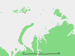
Franz Josef Land
Franz Josef Land, Franz Joseph Land, or Francis Joseph's Land is an archipelago located in the far north of Russia. It is found in the Arctic Ocean north of Novaya Zemlya and east of Svalbard, and is administered by Arkhangelsk Oblast. Franz Josef Land consists of 191 ice-covered islands with a...
, Russia
Russia
Russia or , officially known as both Russia and the Russian Federation , is a country in northern Eurasia. It is a federal semi-presidential republic, comprising 83 federal subjects...
.
Salm Island is almost completely glaciarized except for a cape in its southern shore. Its maximum length is 17 km and its area is 344 km². The highest point of the island, Chernysheva Ice Cap, is 343 m.
Salm Island was named by the Austro-Hungarian North Pole Expedition
Austro-Hungarian North Pole Expedition
The Austro-Hungarian North Pole Expedition was an expedition that ran from 1872–74 and discovered Franz-Josef Land. According to Julius von Payer, one of the leaders, the journey was to find the north-eastern passage. It actually explored the area northwest of Novaya Zemlya. According to the...
after the Salm-Hoogstraeten aristocratic dynasty to which Count Karl Alexander
Karl-Alexander Island
Karl Alexander Island , also known as Zemlya Karla-Alexandra , is an island in Franz Josef Land, Russia.-Location:Its latitude is 81° 28' N and its longitude 57° 50' E....
, one of the expedition's main sponsors, belonged. The Salm-Hoogstraeten dynasty should not be confused with the Hochstetter dynasty.
This island is surrounded by smaller islands.
Adjacent small islands
- Ostrova Bisernyye are two small islets located right off Salm Island's southern shore.
- A few miles to the northeast lie the Hochstetter Islands (oстрова Гохштеттера or oстрова Хохштеттера), made up of a 6.5 km long by 4 km wide island, Hochstetter Island (also known as Gogstettera Yuzhnyy), and two smaller islets Gogstettera Sredniy and ostrov Al'batros. The Hochstetter Islands are named after the German HochstetterHochstetterThe family of Höchstetter from Höchstädt near the banks of the Danube were members of the fifteenth and sixteenth-century mercantile patriciate of Augsburg....
princely dynasty of the Austro Hungarian Empire.
- Roughly north lies 3.7 km long Koldewey IslandKoldewey IslandKoldewey Island is an island in Franz Josef Land, Russia. It is 3,7 km in length, highest point is 66 m . On the top there is a double peak stack . The second highest point Mountain of Robert-Johann in the south west is named after Carl Koldewey's son Robert Koldewey...
(oстров Kольдевея), named after Captain Carl KoldeweyCarl KoldeweyCarl Christian Koldewey was a German Arctic explorer. He led both German North Polar Expeditions.-Life and career:...
leader of the second German expedition to the Arctic in 1869-70. Highest point 66 m.
- Off Koldewey Island's northern point there is a small islet called Schoenau Island (oстров Шёнау). This island was named after Teplitz-Schönau (now TepliceTepliceTeplice , Teplice-Šanov until 1948 is a town in the Czech Republic, the capital of the Teplice District in the Ústí nad Labem Region. It is the state's second largest spa town ....
Czech RepublicCzech RepublicThe Czech Republic is a landlocked country in Central Europe. The country is bordered by Poland to the northeast, Slovakia to the east, Austria to the south, and Germany to the west and northwest....
), the birthplace of Austro-Hungarian Emperor Franz Joseph I.
- Southwest of Salm Island lies 10 km long Wilczek IslandWilczek IslandWilczek Island, is located in the southeastern end of Franz Josef Land, Russia.Wilczek Island is a 10 km long island southwest of Salm Island, separated from the latter by a 3 km wide sound.-History:...
(oстров Вильчека) (which should not be confused with Wilczek LandWilczek LandWilczek Land , is a large-sized island located at . It is a part of Franz Josef Land, Russia.Wilczek Land is the second largest island of the Franz Josef Archipelago. It is almost completely glaciarized except for two narrow areas along its western shores. The highest point on the island is 606...
in the same archipelago). It is separated from Salm Island by a 3 km wide sound. This island is named after Austro Hungarian nobleman Johann Nepomuk Graf Wilczek.
- 4 km southeast of Salm Island lies small and round Litke Island (oстров Литке). Its area is 14 km² and it was named after Russian Count Fyodor Petrovich LitkeFyodor Petrovich LitkeCount Fyodor Petrovich Litke , born Friedrich Benjamin Lütke, was a Russian navigator, geographer, and Arctic explorer. He became a count in 1866, and an admiral in 1855. He was a Corresponding Member , Honorable Member , and President of the Russian Academy of Science in St.Petersburg...
.