
Saint Michael Parish, Barbados
Encyclopedia
| Statistics | |
|---|---|
| Parish: | Saint Michael |
| Area: | 39 km² (15.1 sq mi) |
| Largest city: | Bridgetown Bridgetown The city of Bridgetown , metropolitan pop 96,578 , is the capital and largest city of the nation of Barbados. Formerly, the Town of Saint Michael, the Greater Bridgetown area is located within the parish of Saint Michael... |
| Population (2008 est.): | 94,860 inhab. |
| Population density: | 2,432.31 inhab/km² |
| Parliamentary representation Parliament of Barbados The Parliament of Barbados is the national legislature of Barbados. It is accorded legislative supremacy by Chapter V of the Constitution of Barbados. The Parliament is bicameral in composition and is formally made up of: HM Queen Elizabeth II, Queen of Barbados The Parliament of Barbados is the... | |
| - House seats | 11 |
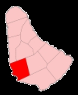
| Map | |
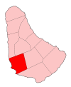 | |
| Parishes of Barbados Parishes of Barbados The country of Barbados is currently subdivided into sub-regions known as parishes. According to the Act of the Barbados Parliament they are officially styled as the "Parish of as opposed to the U.S. styled naming convention with the name "Parish" coming after the name... | |
The parish
Parishes of Barbados
The country of Barbados is currently subdivided into sub-regions known as parishes. According to the Act of the Barbados Parliament they are officially styled as the "Parish of as opposed to the U.S. styled naming convention with the name "Parish" coming after the name...
of St. Michael is one of eleven parishes of Barbados
Barbados
Barbados is an island country in the Lesser Antilles. It is in length and as much as in width, amounting to . It is situated in the western area of the North Atlantic and 100 kilometres east of the Windward Islands and the Caribbean Sea; therein, it is about east of the islands of Saint...
. It has a land area of 39km² and is found at the south-west portion of the island. Saint Michael has survived by name as one of the original six parishes created in 1629 by Governor Sir William Tufton.
The parish is home to Bridgetown
Bridgetown
The city of Bridgetown , metropolitan pop 96,578 , is the capital and largest city of the nation of Barbados. Formerly, the Town of Saint Michael, the Greater Bridgetown area is located within the parish of Saint Michael...
, the capital of Barbados
Barbados
Barbados is an island country in the Lesser Antilles. It is in length and as much as in width, amounting to . It is situated in the western area of the North Atlantic and 100 kilometres east of the Windward Islands and the Caribbean Sea; therein, it is about east of the islands of Saint...
. Bridgetown is the centre of commercial activity in Barbados, as well as a central hub for the public transport network. Other major infrastructure in St. Michael is the international seaport of Barbados—the Deep Water Harbour. Therein, a number of cruise ships arrive and depart including various lines such as Royal Caribbean
Royal Caribbean International
Royal Caribbean International is a Norwegian and American cruise line brand based in Miami, Florida and owned by Royal Caribbean Cruises Ltd.. With 42 ships in service under 5 different brands and one more under construction, it controls a 25.6% share of the world cruise market...
and Cunard
Cunard Line
Cunard Line is a British-American owned shipping company based at Carnival House in Southampton, England and operated by Carnival UK. It has been a leading operator of passenger ships on the North Atlantic for over a century...
. The harbour features several sugar towers for loading locally produced sugar into transport ships, and a tower for loading flour for transport.
Under Barbados' historic vestry
Vestry
A vestry is a room in or attached to a church or synagogue in which the vestments, vessels, records, etc., are kept , and in which the clergy and choir robe or don their vestments for divine service....
system, the main parish church
Church of England parish church
A parish church in the Church of England is the church which acts as the religious centre for the people within the smallest and most basic Church of England administrative region, known as a parish.-Parishes in England:...
(St. Michael's Cathedral) is seated along St. Michael's Row in Bridgetown. This cathedral replaced the former parish church that was formerly located at the site of St. Mary's Church. St. Michael's Cathedral's was elevated to its cathedral status under Bishop Coleridge who arrived to Barbados in 1825-1827 under the then newly established Diocese of Barbados and the Leeward Islands.
Parishes bordering Saint Michael
- Christ Church - South
- Saint George - East
- Saint James - Northwest
- Saint Thomas - Northeast
Defined boundaries
with Christ Church: – Starting from the meeting point of the parishes of St. George, St. Michael, and Christ Church and proceeding in a southerly direction along the plantation track and the boundary between the residential development called Fort George Heights and the Kent House residential development to the junction of the boundary with the public road called Highway R; then in a westerly direction along Highway R to its junction at Wildey with the Airport to West Coast Highway; then in a southerly direction along this Highway to its merging at Clapham with the public road called Highway 6; then in a north-westerly direction along Highway 6 to its junction with the public road called Observatory Road; then in a southerly direction along Observatory Road to its junction with the public road called Fordes Road, then in a south-westerly part of Africa, north-westerly and northerly direction along Fordes Road, Bonnett’s Road and Brittons New Road to its junction with Dalkeith Hill; then in a westerly direction along Dalkeith Hill to its junction with Deighton Road; then in a generally southerly direction along Deighton Road to its junction with Dayrells Road; then in a south-westerly, north-westerly and westerly direction along Dayrells Road to its junction at the Garrison with Dalkeith Road; then in a generally south-westerly direction along Dalkeith Road to its junction with the public road called Highway 7; then directly across Highway 7 and continuing in a south-westerly direction along the road leading to Gravesend Beach and directly to the sea.with St. George: – Starting from the meeting point of the parishes of St. George, St. Michael, and Christ Church and proceeding in a westerly and northerly direction along the plantation track to its junction at lower Birneys with the public road called Highway 5; then in a westerly direction along Highway 5 to its junction at Mapp Hill with the public road called Haynes Hill; then in a northerly direction along Haynes Hill and Pasture Road to its junction with Monroe Road; then in a westerly direction along Monroe Road to its junction with Salters Tenantry Road; then in a northerly, then westerly then northerly direction along Salters Tenantry Road to its junction at Salters with the public road called Highway 4; then in a south-westerly direction along Highway 4 to its junction with a public road called Highway X; then in a north-easterly direction along Highway X to its junction with an unclassified road; then in a generally north-westerly then northerly direction along this road to its junction with the public road leading from the Belle Road to Charles Rowe Bridge; then in a westerly direction along this public road to its junction with the unclassified road leading to Lower Estate; then in a generally north-easterly direction along this road (so as to pass to the east of the factory yard) to its junction with a track to the north of the factory yard; then in a north-westerly direction along this track to join an unclassified road and along this road to its junction at Dayrells with the public road called Highway 3; then in a north-easterly direction along Highway 3 to its junction with Cole Road at Bourne; then in a northerly direction along this road to the culvert where it crosses a gully; then along this gully in a south-westerly, north-westerly and north-easterly direction to a point opposite Applewhaites Tenantry Road; then along the line joining this point to the road junction and in a north-westerly direction along Applewhaites Tenantry Road to its junction with a public road called Highway E. This is the meeting point of the parishes of St. George, St. Michael, and St. Thomas.
with St. James: – Starting from the meeting point of the parishes of St. James, St. Thomas, and St. Michael and proceeding generally westwards along the public road called Clermont Road to its junction with the public road called Husbands Road; then in a southerly direction along this road to its junction with University Drive; then in a westerly and southerly direction along University Drive to the centre of the roundabout at the intersection of this road and Highway 1; then in a north-westerly direction along Highway 1 to a point just south of its junction with an unclassified road called Batt's Rock Road; then from this point in a straight line (bearing 263°07'21") through a monument (B. 18) to the sea.
with St. Thomas: – Starting from the meeting point of the parishes of St. Thomas, St. George, and St. Michael and proceeding along Highway E in a south-westerly direction to the junction with the public road running from Canewood to Jackson; then in a westerly, northerly and north-westerly direction to the junction at Jackson with the public road called Highway 2; then in a south-westerly direction along this road to the centre of the roundabout at its junction at Warrens with the Airport to West Coast Highway; then in a north-westerly direction along this Highway to the centre of the roundabout which is its junction with the public road called Highway 2A; then in a northerly direction along this road to the meeting point of the parishes of St. Thomas, St. James, and St. Michael.
House constituencies
- City of Bridgetown
- Saint Michael-Central
- Saint Michael-East
- Saint Michael-North
- Saint Michael-North East
- Saint Michael-North West
- Saint Michael-South
- Saint Michael-South Central
- Saint Michael-South East
- Saint Michael-West
- Saint Michael-West Central
Places
Found in St. Michael are:- The Gary Sobers Sports complex
- The Kensington OvalKensington OvalThe Kensington Oval is located to the west of the capital-city Bridgetown on the island of Barbados. "The Oval" is one of the major sporting facilities on the island and is primarily used for cricket...
- The National stadiumBarbados National StadiumBarbados National Stadium was officially opened on October 23, 1970. It is a multi-use outdoor stadium in Waterford, St. Michael, Barbados. Situated approximately 4.3km northeast of Bridgetown it is located off Highway 3. The stadium is currently used mostly for football matches...
- The Lloyd Erskine Sandiford Conference And Cultural Centre
- The local Psychiatric Hospital, commonly called Jenkins
- The Queen Elizabeth HospitalQueen Elizabeth Hospital, BridgetownThe Queen Elizabeth Hospital is located in Barbados' capital city Bridgetown, which is located in the parish of Saint Michael. The hospital is the main General Hospital for the southern part of the island....
, Barbados' primary health care facility - Government HouseGovernment House, BarbadosThe Government House is the official residence and office of the Governor-General of Barbados. It was built in the colonial days and was the residence of the Governor of Barbados. It later continued in the role of official residence and office of the Governor-General following political...
, the official residence of the Governor-General of Barbados - Various government offices such as the Ministry of Education and the Ministry of Industry and International Business
Education
Several schools are located in St. Michael including:- Barbados Community College http://www.bcc.edu.bb/
- The Cave Hill campus of the University of the West IndiesUniversity of the West IndiesThe University of the West Indies , is an autonomous regional institution supported by and serving 17 English-speaking countries and territories in the Caribbean: Anguilla, Antigua and Barbuda, The Bahamas, Barbados, Belize, Bermuda, the British Virgin Islands, the Cayman Islands, Dominica,...
- The Cave Hill School of Business http://www.uwichsb.org/
- Combermere School
- Erdiston Teachers' Training College
- Harrison CollegeHarrison CollegeHarrison College may refer to:* Harrison College , a higher education institution based in Indiana with campuses online and in Columbus, Ohio* Harrison College , a secondary school in Bridgetown, Barbados...
- The Samuel Jackson Prescod Polytechnic http://www.sjpp.edu.bb/
- The St. Michael SchoolThe St. Michael SchoolThe St. Michael School is a secondary school in Barbados. It stands on Martindales Road in the parish of Saint Michael, Barbados. The school has over 800 pupils....